Machu Picchu
Videos
Photos
Machu Picchu is a 15th-century Inca citadel located in the Eastern Cordillera of southern Peru on a 2,430-meter (7,970 ft) mountain ridge. Often referred to as the "Lost City of the Incas", it is the most familiar icon of the Inca Empire. It is located in the Machupicchu District within Urubamba Province above the Sacred Valley, which is 80 kilometers (50 mi) northwest of Cusco. The Urubamba River flows past it, cutting through the Cordillera and creating a canyon with a tropical mountain climate. In reference to the site's name, for most English or Spanish speakers, the first 'c' in Picchu is silent. In English, the name is pronounced MAH-choo PEE-choo or MATCH-oo PEAK-choo, in Spanish as or, and in Quechua as.

Machu Picchu in 2007

Photo by Hiram Bingham III in 1912 after major clearing and before reconstruction work began

View of the ancient houses

Terraces used for farming at Machu Picchu
Inca Empire
Videos
Photos
The Inca Empire, called Tawantinsuyu by its subjects, was the largest empire in pre-Columbian America. The administrative, political, and military center of the empire was in the city of Cusco. The Inca civilization rose from the Peruvian highlands sometime in the early 13th century. The Spanish began the conquest of the Inca Empire in 1532 and by 1572, the last Inca state was fully conquered.
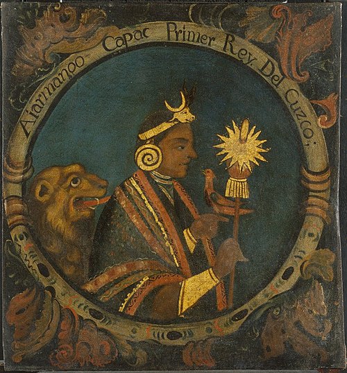
Manco Cápac, First Inca, 1 of 14 Portraits of Inca Kings, Probably mid-18th century. Oil on canvas. Brooklyn Museum

An Inca prince accompanied by nobles, priests and warriors

The first image of the Inca in Europe, Pedro Cieza de León, Crónica del Perú, 1553

Sapa inkakuna, a 17th-century Cusco painting with the Inca lineages mentioned by colonial chronicles and their relationship with the royal queens of Cusco, which hide behind a complex representation of the Inca social organization.