Mackinac Island State Park
Mackinac Island State Park is a state park located on Mackinac Island in the U.S. state of Michigan. A Lake Huron island, it is near the Straits of Mackinac. The island park encompasses 1,800 acres (7.3 km2), which is approximately 80% of the island's total area. The park is also within the boundaries of the city of Mackinac Island and has permanent residents within its boundaries. M-185 circles the perimeter of the park as the only motorless highway in the state due to the island's ban of automobiles. The park is governed by the Michigan Department of Natural Resources and the Mackinac Island State Park Commission. On July 15, 2009, the park celebrated its 20 millionth visitor.
Fort Mackinac
Arch Rock, Mackinac Island, 7.26.2014
Mackinac Island is an island and resort area, covering 4.35 square miles (11.3 km2) in land area, in the U.S. state of Michigan. The name of the island in Odawa is Michilimackinac and "Mitchimakinak" in Ojibwemowin, meaning "Great Turtle". It is located in Lake Huron, at the eastern end of the Straits of Mackinac, between the state's Upper and Lower Peninsulas. The island was long home to an Odawa settlement and previous indigenous cultures before European colonization began in the 17th century. It was a strategic center of the fur trade around the Great Lakes. Based on a former trading post, Fort Mackinac was constructed on the island by the British during the American Revolutionary War. It was the site of two battles during the War of 1812 before the northern border was settled and the US gained this island in its territory.
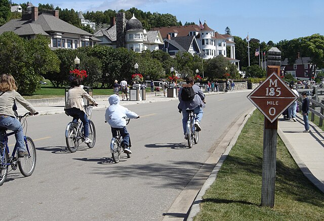
Cyclists on M-185 (Main Street) at mile marker 0 in downtown Mackinac Island
Dwightwood Spring, on Mackinac Island's eastern shore
The statue of Jacques Marquette, Jesuit priest and Great Lakes explorer, in front of Fort Mackinac
A view of M-185 through Arch Rock