Manuʻa Islands
Videos
The Manuʻa Islands, or the Manuʻa tele, in the Samoan Islands, consists of three main islands: Taʻū, Ofu and Olosega. The latter two are separated only by the shallow, 137-meter-wide Āsaga Strait, and are now connected by a bridge over the strait. The islands are located some 110 kilometers east of Tutuila and are a part of American Samoa, an unincorporated territory of the United States. Their combined area is 56 square kilometers, and they have a total population of 1,400. Taʻu is the largest of these islands, with an area of 44 km2 (17 sq mi), and it has the highest point of the Manuʻa, at 931 meters. Politically, the islands form the Manuʻa District, one of the three administrative divisions of American Samoa.

The Islands of Ofu and Olosega viewed from the village of Sili along the north shore of Olosega. The middle peak is Sunuʻitao on Ofu, across the narrow strait at Asaga from Olosega (foreground and mountain on left)

Tuimanuʻa Elisara
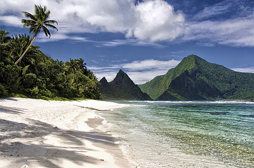
Ofu Beach on Ofu Island

Samoan fale in the Manu'a island group, showing thatched roof and woven pola blinds, circa 1890 - 1910.See also: Architecture of Samoa.
Taʻū
Videos
Taʻū is the largest inhabited island in the Manuʻa Islands and the easternmost volcanic island of the Samoan Islands. Taʻū is part of American Samoa. In the early 19th century, the island was sometimes called Opoun.

Ta'u as seen from space

A coral colony off the island. Discovered by the National Oceanic and Atmosphere Administration, it is one of the largest colonies in the world.