Mount Adams (Washington)
Videos
Mount Adams is a stratovolcano located in the Cascade Range of Washington, United States. Standing at 12,276 ft feet, it is the second-highest mountain in Washington and a prominent feature within the

Mount Adams from the south

Meadows at Mount Adams Wilderness

Panoramic view from the relatively flat summit area of Mount Adams, with the center of the image looking due west towards Mount St. Helens. Nine Cascade Volcanoes are visible (not including Adams itself). From left to right: Three Sisters complex, Mount Jefferson, Mount Hood, Mount St. Helens, Mount Rainier, Mount Baker, and Glacier Peak. The Olympic Mountains can be seen between St. Helens and Rainier, nearly 150 miles away.

Trout Lake (Trout Lake Creek) reflecting Mount Adams near the small town of Trout Lake.
Mount St. Helens
Videos
Mount St. Helens is an active stratovolcano located in Skamania County, Washington, in the Pacific Northwest region of the United States. It lies 52 miles northeast of Portland, Oregon, and 98 miles s
Mount Adams (Washington)
…formed as a result of the subduction of the Juan de Fuca Plate beneath the North American Plate. Adams is near two more-frequently erupting neighbors, Mount St Helens and Mount Rainier. It has twelve named glaciers descending its slopes. Geologically, Mount Adams first formed in the Pleistocene. Its construction…

3,000 ft (900 m) high steam plume on May 19, 1982, two years and a day after the 1980 major eruption that created the visible gap on the north side of the mountain
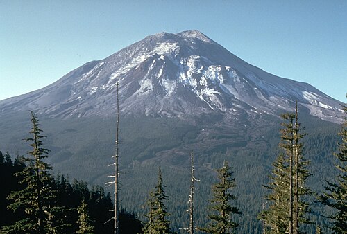
Mount St. Helens pictured the day before the 1980 eruption, which removed much of the northern face of the mountain, leaving a large crater

Aerial view with Mount Adams in background

East Dome on the east flank of Mount St. Helens in 2013.