New York–New Jersey Harbor Estuary
Videos
Photos
The New York–New Jersey Harbor Estuary, also known as the Hudson-Raritan Estuary, is in the northeastern states of New Jersey and New York on the East Coast of the United States. The system of waterways of the Port of New York and New Jersey forms one of the most intricate natural harbors in the world and one of the busiest ports of the United States. The harbor opens onto the New York Bight in the Atlantic Ocean to the southeast and Long Island Sound to the northeast.

A 2011 NASA image of New York–New Jersey Harbor Estuary

Population density and elevation above sea level in the New York City metropolitan area as of 2010

An aerial view of New York–New Jersey Harbor Estuary
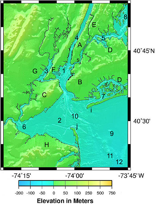
1. Upper New York Bay 2. Lower New York Bay 3. Newark Bay 4. Hudson River 5. East River 6. Raritan Bay 7. Jamaica Bay 8. Long Island Sound 9. New York Bight-North Atlantic 10. Ambrose Channel 11. Mud Dump Site 12. Hudson Canyon A. Manhattan B. Brooklyn C. Staten Island D. Queens E. The Bronx F. Bayonne-Jersey City G. Newark H. Raritan Bayshore i. Rockaway Point j. Sandy Hook (This is not for navigation.)
Port of New York and New Jersey
Videos
Photos
The Port of New York and New Jersey is the port district of the New York-Newark metropolitan area, encompassing the region within approximately a 25-mile (40 km) radius of the Statue of Liberty National Monument.

Port Newark–Elizabeth Marine Terminal on Newark Bay is the busiest container terminal on the East Coast of the United States.
NASA image of the greater Newark and New York area, including the port district

Deepening of Kill van Kull

The Port of New York and New Jersey grew from the original harbor at the convergence of the Hudson River and the East River at the Upper New York Bay.