Northwest Passage
Videos
The Northwest Passage (NWP) is the sea lane between the Atlantic and Pacific oceans through the Arctic Ocean, along the northern coast of North America via waterways through the Arctic Archipelago of Canada. The eastern route along the Arctic coasts of Norway and Siberia is accordingly called the Northeast Passage (NEP).
The various islands of the archipelago are separated from one another and from Mainland Canada by a series of Arctic waterways collectively known as the Northwest Passages, Northwestern Passages or the Canadian Internal Waters.
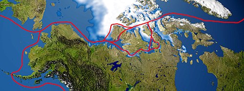
Northwest Passage routes

Envisat ASAR mosaic of the Arctic Ocean (September 2007), showing the most direct route of the Northwest Passage open (yellow line) and the Northeast Passage partially blocked (blue line). The dark grey colour represents the ice-free areas, while green represents areas with sea ice.

Chart of the World showing New Route (the Canadian Pacific Railway) through Canada between England, China, Japan, Australasia and the East (1886)

9 August 2013
Arctic
Videos
The Arctic is a polar region located at the northernmost part of Earth. The Arctic region, from the IERS Reference Meridian travelling east, consists of parts of northern Norway, northernmost Sweden, northern Finland, Russia, the United States (Alaska), Canada, Danish Realm (Greenland), and northern Iceland, along with the Arctic Ocean and adjacent seas. Land within the Arctic region has seasonally varying snow and ice cover, with predominantly treeless permafrost under the tundra. Arctic seas contain seasonal sea ice in many places.

MODIS image of the Arctic

A snowy landscape of Inari located in Lapland (Finland)

Arctic poppy in bloom within the Qausuittuq National Park on Bathurst Island

Muskox