Olympia Undae
Videos
Olympia Undae is a vast dune field in the north polar region of the planet Mars. It consists of a broad "sand sea" or erg that partly rings the north polar plateau from about 120° to 240°E longitude and 78° to 83°N latitude. Stretching about 1,100 km (680 mi) across and covering an area of 470,000 km2, Olympia Undae is the largest continuous dune field on Mars. It is similar in size to the Rub' Al Khali in the Arabian Peninsula, the largest active erg on Earth.


Olympia Undae dunes, as seen by HiRISE. Two sets of transverse dunes are visible, indicating varying wind direction. Olympia Undae is also known as the North Polar Erg.

Closeup, color-enhanced image of Olympia Undae dunes with melting/subliming ice-cap fragments. Note Barchan dunes and patterned ground. Width of image is about 1 km/3000 ft.

CRISM spectral signal for gypsum (polyhydrated sulfates) in Olympia Undae dunes.
Planum Boreum
Videos
Planum Boreum is the northern polar plain on Mars. It extends northward from roughly 80°N and is centered at 88.0°N 15.0°E. Surrounding the high polar plain is a flat and featureless lowland plain called Vastitas Borealis which extends for approximately 1500 kilometers southwards, dominating the northern hemisphere.

Viking mosaic of Planum Boreum and surrounds

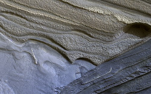
False color HiRISE image of a side of the Chasma Boreale, a canyon in the polar ice cap. Light browns are layers of surface dust greys and blues are layers of water and carbon dioxide ice. Regular geometric cracking is indicative of higher concentrations of water ice.
False color HiRISE view of water ice layers in Olympia Rupes, believed by scientists to be preserving climate conditions of Mars dating back millions of years. Depicted width: 1.3 km (3⁄4 mi)

November 27, 2011