Planum Boreum
Videos
Planum Boreum is the northern polar plain on Mars. It extends northward from roughly 80°N and is centered at 88.0°N 15.0°E. Surrounding the high polar plain is a flat and featureless lowland plain called Vastitas Borealis which extends for approximately 1500 kilometers southwards, dominating the northern hemisphere.

Viking mosaic of Planum Boreum and surrounds

False color HiRISE image of a side of the Chasma Boreale, a canyon in the polar ice cap. Light browns are layers of surface dust greys and blues are layers of water and carbon dioxide ice. Regular geometric cracking is indicative of higher concentrations of water ice.
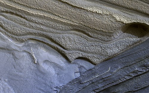
False color HiRISE view of water ice layers in Olympia Rupes, believed by scientists to be preserving climate conditions of Mars dating back millions of years. Depicted width: 1.3 km (3⁄4 mi)

November 27, 2011
Vastitas Borealis
Videos
Vastitas Borealis is the largest lowland region of Mars. It is in the northerly latitudes of the planet and encircles the northern polar region. Vastitas Borealis is often simply referred to as the northern plains, northern lowlands or the North polar erg of Mars. The plains lie 4–5 km below the mean radius of the planet, and is centered at 87.73°N 32.53°E. A small part of Vastitas Borealis reaches below 65°N.

Vastitas Borealis is the large low elevation area surrounding 70°N.

Surface of Mars, as seen by Phoenix. The ground is shaped into polygons which are common where the ground freezes and thaws.

Olympia Planitia Dunes, as seen by HiRISE. Gypsum has been detected here by MRO.

Patterned ground was once called fingerprint terrain because it looked like giant fingerprints. The dark dots are actually chains of low mounds. The center circular feature is a ring of dark boulders on the rim of a buried crater. Picture from Mars Global Surveyor.