From 1890 through 2006, the Orleans Levee Board (OLB) was the body of commissioners that oversaw the Orleans Levee District (OLD) which supervised the levee and floodwall system in Orleans Parish, Louisiana The role of the OLB has changed over time. Prior to Hurricane Betsy in 1965, the OLB developed land and sold it to raise money to build and improve flood protection levees. After Betsy, Congress passed the Flood Control Act of 1965 which directed the Army Corps of Engineers to design and build the hurricane flood protection system enveloping New Orleans. Owing to the 1965 legislation, the OLB's duties were now limited to collecting the 30% cost share for project design and construction, and to maintaining and operating completed flood protection structures.
Debris set on curb from flood-damaged Uptown home includes trashed "Katrina refrigerator" with graffiti labeling it as a "levee board victim."
2005 levee failures in Greater New Orleans
On Monday, August 29, 2005, there were over 50 failures of the levees and flood walls protecting New Orleans, Louisiana, and its suburbs following passage of Hurricane Katrina. The failures caused flooding in 80% of New Orleans and all of St. Bernard Parish. In New Orleans alone, 134,000 housing units — 70% of all occupied units — suffered damage from Hurricane Katrina and the subsequent flooding.
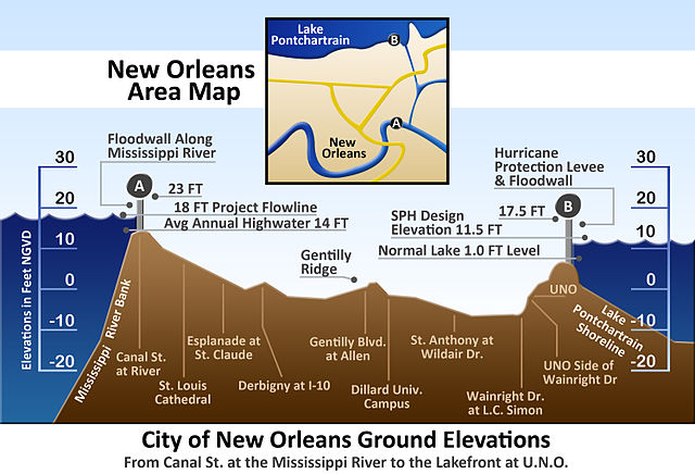
Vertical cross-section of New Orleans, showing maximum levee height of 23 feet (7 m) at the Mississippi River on the left and 17.5 feet (5 m) at Lake Pontchartrain on the right
Breach in 17th Street Canal levee on August 31, showing the inundated Lakeview neighborhood on the right and the largely dry Metairie side on the left (NOAA)
Severely damaged homes in piles of sand near the upper London Avenue Canal breach
Portion of the flood wall atop 17th Street Canal levee, with Katrina-related graffiti. Notice cracks in the flood wall joints. Operation and maintenance are the responsibility of local levee districts as mandated by the Flood Control Act of 1965.


