Suburb
A suburb is a mixed-use or residential area, existing either as part of a city or urban area or as a separate residential community within commuting distance of a city. In most English-speaking countries, suburban areas are defined in contrast to central or inner-city areas, but in Australian English and South African English, suburb has become synonymous with what is called a "neighborhood" in other countries and the term extends to inner-city areas. In some areas, such as Australia, China, New Zealand, the United Kingdom, a few U. S. states, new suburbs are annexed by adjacent cities. In others, such as Saudi Arabia, Canada and much of the United States, many suburbs remain separate municipalities or are governed as part of a larger local government area such as a county. Suburbs first emerged on a large scale in the 19th and 20th centuries as a result of improved rail and road transport, which led to an increase in commuting. In general, they have lower population densities than inner city neighborhoods within a metropolitan area, most residents commute to central cities or other business districts.
Suburbs tend to proliferate around cities that have an abundance of adjacent flat land. The English word is derived from the Old French subburbe, in turn derived from the Latin suburbium, formed from sub and urbs; the first recorded usage of the term in English, was made by John Wycliffe in 1380, where the form subarbis was used, according to the Oxford English Dictionary. In Australia and New Zealand, suburbs have become formalised as geographic subdivisions of a city and are used by postal services in addressing. In rural areas in both countries, their equivalents are called localities; the terms inner suburb and outer suburb are used to differentiate between the higher-density areas in proximity to the city center, the lower-density suburbs on the outskirts of the urban area. The term'middle suburbs' is used. Inner suburbs, such as Te Aro in Wellington, Eden Terrace in Auckland, Prahran in Melbourne and Ultimo in Sydney, are characterised by higher density apartment housing and greater integration between commercial and residential areas.
In New Zealand, most suburbs are not defined which can lead to confusion as to where they may begin and end. Although there is a geospatial file defining suburbs for use by emergency services developed and maintained by Fire and Emergency New Zealand, in collaboration with other government agencies, to date this file has not been released publicly. New Zealand company Koordinates Limited requested access to the geospatial file under the Official Information Act 1982 but this request was rejected by the New Zealand Fire Service on the basis that it would prejudice the health & safety of, or cause material loss, to the public. In September 2014 a decision was made by the Ombudsman of New Zealand ruling that the New Zealand Fire Service refusal to release the geospatial file without agreeing to terms which included, among other restrictions, a prohibition on redistribution of the geospatial file, was reasonable. In the United Kingdom and in Ireland, suburb refers to a residential area outside the city centre, regardless of administrative boundaries.
Suburbs, in this sense, can range from areas that seem more like residential areas of a city proper to areas separated by open countryside from the city centre. In large cities such as London and Leeds, suburbs include separate towns and villages that have been absorbed during a city's growth and expansion, such as Ealing and Guiseley. In the United States and Canada, suburb can refer either to an outlying residential area of a city or town or to a separate municipality or unincorporated area outside a town or city; the earliest appearance of suburbs coincided with the spread of the first urban settlements. Large walled towns tended to be the focus around which smaller villages grew up in a symbiotic relationship with the market town; the word'suburbani' was first used by the Roman statesman Cicero in reference to the large villas and estates built by the wealthy patricians of Rome on the city's outskirts. Towards the end of the Eastern Han Dynasty, the capital, was occupied by the emperor and important officials.
As populations grew during the Early Modern Period in Europe, urban towns swelled with a steady influx of people from the countryside. In some places, nearby settlements were swallowed up as the main city expanded; the peripheral areas on the outskirts of the city were inhabited by the poorest. Due to the rapid migration of the rural poor to the industrialising cities of England in the late 18th century, a trend in the opposite direction began to develop; this trend accelerated through the 19th century in cities like London and Manchester that were growing and the first suburban districts sprung up around the city centres to accommodate those who wanted to escape the squalid conditions of the industrial towns. Toward the end of the century, with the development of public transit systems such as the underground railways and buses, it became possible for the majority of the city's population to reside outside the city and to commute into the
Pakuranga
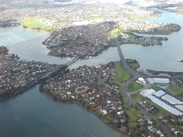
Pakuranga is a south-eastern suburb of Auckland, in northern New Zealand. Pakuranga covers a series of low ridges and swampy flats, now drained, that lie between the Pakuranga Creek and Tamaki River, two estuarial arms of the Hauraki Gulf, it is located to the north of Manukau and 15 kilometres southeast of the Auckland CBD. The suburb's name is Te Pakūrangarāhihi Maori for battle of the sunlight or battle of the sun's rays. A fierce battle over forbidden love raged between two patupaiarehe - fairy people of the forest - until a priest caused the sun to rise and the earth to explode. Caught by the rays of the sun and volcanic eruptions, many patupaiarehe perished.. Pakuranga is traditionally home to the Ngāi Tai Iwi known as Ngāi Tai Ki Tāmaki; the prominent pa were at Ohuiarangi / Pigeon Mountain and Mokoia Pā of Ngāti Paoa at Panmure on a cliff, at the intersection of the Te Wai Ō Taiki / Tamaki River and the inlet to the Panmure Basin. During the attacks by Ngapuhi in the Musket wars in late September 1820, most of the population were killed, taken prisoner or fled south to the Waikato.
In early European times, it was a sparsely settled dairy farming area between the townships of Panmure and Howick. In the 1920s and 30s it was served by a bus that ran from Bucklands Beach known as the "shiek". In the 1930s a concrete road was built between these townships that improved transport times for people and milk. Although there had been a hinged steel bridge over the Tamaki River to Panmure from as early as 1866, it was not until the construction of a sturdier structure across the Tamaki River in the 1950s, coinciding with a demand for more settlement land and the increasing levels of car ownership, that Pakuranga became suburban. In fact, for a while in the 70s it was considered the typical New Zealand middle class suburb,'Vim Valley', after'a typical Pakuranga housewife' was featured in a famous cleaning product ad. Many of the American style houses of the 1950s and 1960s are still noticeable but much of the appeal of the early suburb lay in the proximity of untouched countryside.
Since the 1970s Pakuranga has been surrounded and engulfed by suburban developments on a much larger scale but of less architectural merit. Traffic travelling to and from these suburbs and the centre of Auckland is funnelled through the roadways of Pakuranga which has degraded the area somewhat as well. Despite this today Pakuranga remains an attractive suburb, with some light industry, centred on the Pakuranga Town Centre 1965, the second built in New Zealand, now known as "The Plaza"; the mall the second mall of the modern age in New Zealand, incorporating Farmers and George Court department stores. The mall itself has been transformed several times since it first went up and retains little of the 1960s style it once had; the Te Tuhi Centre for the Arts is located nearby. There was no school in the area before the 1960s so children had to walk or ride horses to the old Howick school, located across from the Highland Park shops; the old school was moved to the old village display in Pakuranga.
Pakuranga College was built on a low-lying swampy piece of land south of Pigeon Mountain opening in May 1961 with a roll of 428. Edgewater College was built on low-lying swamp land known as Fletcher's Bog near the Tamaki River, it opened in 1968. Schools in Pakuranga include the private school Saint Kentigern College. Pakuranga History of Howick and Pakuranga Google Map of Pakuranga Te Tuhi Centre for the Arts Photographs of Pakuranga held in Auckland Libraries' heritage collections
Ngāpuhi
Ngāpuhi is a Māori iwi located in the Northland region of New Zealand, centred in the Hokianga, the Bay of Islands, Whangarei. Ngāpuhi has the largest affiliation of any iwi, with 125,601 people identifying as Ngāpuhi in the 2013 census, formed from 150 hapū/subtribes, with 55 marae. Despite such diversity, the people of Ngāpuhi maintain self-identity; the iwi is administered based in Kaikohe. The Rūnanga acts on behalf of the iwi in consultations with the New Zealand Government, it ensures the equitable distribution of benefits from the 1992 settlement with the Government, undertakes resource management and education initiatives. The founding ancestor of Ngāpuhi is the son of Tauramoko and Te Hauangiangi. Tauramoko was a descendant of Kupe, from Matawhaorua, Nukutawhiti, of the Ngātokimatawhaorua canoe. Te Hauangiangi was the daughter of Puhi, who captained the Mataatua canoe northwards from the Bay of Plenty. Rāhiri was born near Opononi in the Hokianga; the early tribes led by Rāhiri's descendants lived in the Hokianga and Pouerua areas.
Through intermarriage with other iwi and expansionist land migration, the descendants of Rāhiri formed tribes across the Northland peninsula. These actions fostered ties with neighbouring iwi. Auha and Whakaaria, for example, led expansion eastward from Kaikohe and Pouērua into the Bay of Islands area and intermarrying with Ngāi Tāhuhu, Ngāti Manaia, Te Wahineiti and Ngāti Miru; these tribes in the east were the first to use the name Ngāpuhi. As the eastern and western groups merged, the name came to describe all the tribes settled in the Hokianga and Bay of Islands. In the late 1700s and early 1800s the Ngāpuhi tribes pushed further east through the southern Bay of Islands to the open coast, absorbing tribes such as Ngāti Manu, Te Kapotai, Te Uri o Rata, Ngare Raumati and Ngātiwai. Ruatara was chief of the Ngāpuhi from 1812 to his death in 1815. In 1814, he invited the Rev. Samuel Marsden to set up the first Christian mission in New Zealand on Ngāpuhi land; the presence of these influential Pakeha secured Ruatara's access to European plants and knowledge, which he distributed to other Māori, thus increasing his mana.
After the death of Ruatara, his uncle Hongi Hika became protector of the mission. Thomas Kendall, John King, William Hall, missionaries of the Church Missionary Society, founded the first mission station in Oihi Bay in the Bay of Islands in 1814 and over the next decades established farms and schools in the area. In 1823 Rev. Henry Williams and his wife Marianne established a mission station at Paihia on land owned by Ana Hamu, the wife of Te Koki. In 1826 Henry's brother William and his wife Jane joined the CMS mission at Paihia. Marianne and Jane Williams established schools for the Ngāpuhi. William Williams lead the CMS missionaries in the translation of the Bible and other Christian literature; the missionaries did not succeed in converting a single Māori until 1830 when Rawiri Taiwhanga, a Ngāpuhi chief, was baptised. Ruatara and Hongi Hika themselves did not convert. Hōne Heke attended the CMS mission school at Kerikeri and Heke and his wife Ono, were baptised in 1835. By the early 19th century, the Bay of Islands had become a prominent shipping port in New Zealand.
Through increased trade with Europeans, initiated by Ruatara, Ngāpuhi gained greater access to European weapons, including muskets. Armed with European firearms, led by Hongi Hika, launched a series of expansionist campaigns, with resounding slaughters across Northland and in the Waikato and Bay of Plenty. On 28 October 1835 various Northland chiefs from the Ngapuhi tribe, met at Waitangi with British resident James Busby and signed the Declaration of Independence of New Zealand, proclaiming the United Tribes of New Zealand. In 1836, the Crown received and recognized the United Tribes independence under King William IV. By 1839, 52 chiefs from around Northland and central North Island had signed the Declaration, including most Ngāpuhi chiefs and Pōtatau Te Wherowhero, ariki of the Tainui tribes of the Waikato. In 1840, the Ngāpuhi chiefs were all signatories to the Treaty of Waitangi. However, from 1845–1846, Ngāpuhi fought against the British Crown over treaty disputes and European encroachment and interference.
The Māori forces were led by Te Ruki Kawiti and Hōne Heke, who instigated the war when he chopped down the flagpole at Kororāreka to commence what is sometimes called the Flagstaff War. The British had Ngāpuhi allies; the outcome of the Flagstaff War is a matter of some debate. Although the war was lauded as a British victory, it is clear that the outcome was somewhat more complex contentious; the flagstaff which had proved so controversial was not re-erected by the colonial government. Whilst the Bay of Islands and Hokianga was still nominally under British influence, the fact that the Government's flag was not re-erected was symbolically significant; such significance was not lost on Henry Williams, writing to E. G. Marsh on 28 May 1846, stating that "the flag-staff in the Bay is still prostrate, the natives here rule; these are humiliating facts to the proud Englishman, many of whom thought they could govern by a mere name."The flagstaff that now stands at Kororareka was erected in January 1858 at the direction of Kawiti's son Maihi Paraone Kawiti.
Mount Wellington, New Zealand
Mount Wellington is a suburb in East Auckland, New Zealand, located 10 kilometres southeast of the city centre. It is surrounded by the suburbs of Stonefields, Panmure and Ellerslie, by the Tamaki River; the suburb is named after the volcanic peak of Maungarei / Mount Wellington. Sylvia Park is a large business shopping centre located in the suburb. Maungarei / Mount Wellington is a 135-metre volcanic peak of the Auckland volcanic field, it is the youngest onshore volcano of the Auckland volcanic field, having been formed by an eruption around 10,000 years ago. It is the largest of Auckland's scoria cones, it is not expected to erupt again. Bailey Road School is a state, coeducational full primary school with a roll of 418 and a decile rating of 3. Stanhope Road School is a state, coeducational full primary school with a roll of 495 and a decile rating of 4, it was established in 1958. Sylvia Park School is a state, coeducational full primary school with a roll of 248 and a decile rating of 2. Stonefields School is a school right at the base of Mt Wellington.
It is a full primary school Volcanoes of Auckland: The Essential guide - Hayward, B. W. Murdoch, G. Maitland, G.. Bailey Road School Stanhope school Sylvia Park School Photographs of Mount Wellington held in Auckland Libraries' heritage collections
Stuff.co.nz
Stuff.co.nz is a New Zealand news website published by Stuff Limited, a subsidiary of Australian company Fairfax Media Ltd. Stuff hosts the websites for Fairfax's New Zealand newspapers, including the country's second- and third-highest circulation daily newspapers, The Dominion Post and The Press, the highest circulation weekly, The Sunday Star-Times, it is a web portal to other Fairfax websites. As of March 2019, the website had an Alexa rank in New Zealand of 7; the former New Zealand media company Independent Newspapers Ltd, owned by News Corp Australia, launched Stuff on 27 June 2000 at a cybercafe in Auckland, after announcing its intention to go online more than a year earlier. The development of Stuff was supported and governed by, the INL Board, Mike Robson, INL CEO, Don Higgins, Corporate Development Manager. Mark Wierzbicki, founding Internet Business Manager, lead development and ongoing management of the Stuff site and team. Advertising agency Saatchi & Saatchi conceived the name "Stuff", INL had to buy the domain name from a cyber squatter.
In its first month, the site had 120,000 unique visitors. At the time, Mark Wierzbicki, described the name as a copywriter's dream, although he conceded that "it's not without risk if we stuff up." The start up website was built by a group of tech companies in Wellington led by project manager Bill Alp and founding CTO & engineering manager Will Everitt and used a software platform from News Corp Australia's news.com.au. On 30 June 2003, INL sold its publishing assets including The Dominion Post, The Press, the Stuff website to Fairfax Media. Fairfax upgraded the website in December 2006, again on 4 March 2009, adding the ability for visitors to personalise the homepage; the first mobile phone news service from Stuff began in 2003, in a partnership with Vodafone New Zealand. On 21 April 2009, Stuff launched a dedicated mobile site, m.stuff.co.nz. For larger news events, the site creates a dedicated section, such as for the Bain family murders retrial and the February 2011 Christchurch earthquake.
During the trial of Clayton Weatherston, press.co.nz, a subsidiary section on Stuff accidentally ran the headline "Guilty of Murder" the day before the jury delivered the verdict. The article was withdrawn, Fairfax executive editor Paul Thompson said it was a mistake "we take seriously."The site has won numerous awards including the Newspaper Publishers' Association awards "Best News Website" for 2010 and 2011. On 17 April 2013, to celebrate the passing of same-sex marriage in New Zealand, the colour of the Stuff logo was changed from black to the colours associated with the pride flag. On 1 February 2018 the parent company of Stuff.co.nz changed its name from Fairfax New Zealand Limited to Stuff Limited. Media of New Zealand Official website Archivestuff
Hongi Hika
Hongi Hika was a New Zealand Māori rangatira and war leader of the Ngāpuhi iwi. Hongi Hika used European weapons to overrun much of northern New Zealand in the first of the Musket Wars, he encouraged Pākehā settlement, patronised New Zealand's first missionaries, introduced Māori to Western agriculture and helped put the Māori language into writing. He travelled to England and met King George IV. Hongi Hika's military campaigns, the other Musket Wars were one of the most important stimuli for the British annexation of New Zealand and subsequent Treaty of Waitangi with Ngāpuhi and many other iwi, he was a pivotal figure in the period when Māori history emerged from myth and oral tradition and Pākehā began settlements rather than simple exploration. Hongi Hika was born at Kaikohe into a chiefly family of the Te Uri o Hua hapū of Ngāpuhi, his mother was a Ngāti Kahu woman from Whangaroa. His father was Te Hōtete, son of Auha, who with his brother Whakaaria had expanded Ngāpuhi's territory from the Kaikohe area into the Bay of Islands area.
Hongi Hika once said he was born in the year explorer Marion du Fresne was killed by Māori—in 1772—though other sources place his birth around 1780. Hongi Hika rose to prominence as a military leader in the Ngāpuhi campaign, led by Pokaia, against the Te Roroa hapu of Ngāti Whātua iwi in 1806–1808. In over 150 years since the Maori first begun sporadic contact with Europeans, firearms had not entered into widespread use. Ngāpuhi fought with small numbers of them in 1808, Hongi Hika was present that same year on the first occasion that muskets were used in action by Māori; this was at the battle of Moremonui. Those killed included two of Hongi Hika's brothers and Pokaia, Hongi Hika and other survivors only escaped by hiding in a swamp until Ngāti Whātua called off the pursuit to avoid provoking utu. Hongi Hika became the war leader of the Ngāpuhi, his warriors included Te Ruki Kawiti, Moka Te Kainga-mataa, Ruatara, Motiti and Mahanga. In 1812 he led a large taua to the Hokianga against Ngāti Pou.
Despite his earlier experiences he seems to have become convinced of the value of muskets which were used during this campaign. In 1825 Hongi avenged the earlier defeat of Moremonui in the battle of Te Ika-a-Ranganui, although both sides suffered heavy losses. Ngāpuhi controlled the Bay of Islands, the first point of contact for most Europeans visiting New Zealand in the early 19th century. Hongi Hika protected early missionaries and European seamen and settlers, arguing the benefits of trade, he befriended Thomas Kendall—one of three lay preachers sent by the Church Missionary Society to establish a Christian toehold in New Zealand. In 1814 Hongi Hika and his nephew Ruatara, the then-leader of the Ngāpuhi, visited Sydney, with Kendall and met the local head of the Church Missionary Society Samuel Marsden. Ruatara and Hongi Hika invited Marsden to establish the first Anglican mission to New Zealand in Ngāpuhi territory. Ruatara died the following year. In 1817 Hongi led a war party to Thames where he attacked the Ngati Maru stronghold of Te Totara, killing 60 and taking 2000 prisoners.
On 4 July 1819 he granted 13,000 acres of land at Kerikeri to the Church Missionary Society in return for 48 felling axes, land which became known as the Society's Plains. He assisted the missionaries in developing a written form of the Māori language. Hongi Hika never converted to Christianity. In life, in exasperation with teachings of humility and non-violence, he described Christianity as “a religion fit only for slaves”, he protected the Pākehā Māori Thomas Kendall when he “went native”, taking a Māori wife and participating in Māori religious ceremonies. Though Hongi Hika encouraged the first missions to New Zealand no Māori converted to Christianity for a decade. While in Australia Hongi Hika studied European military and agricultural techniques and purchased muskets and ammunition. From 1818 he introduced European agricultural implements and the potato, using slave labour to produce crops for trade. Hongi married Turikatuku, an important military advisor for him, although she went blind early in their marriage.
He took her sister Tangiwhare as additional wife. Both bore at least one daughter by him, it is uncertain. In 1818 Hongi Hika led one of two Ngāpuhi taua against East Cape and Bay of Plenty iwi Ngāti Porou and Ngaiterangi; the taua returned in 1819 carrying nearly 2,000 captured slaves. In 1820 Hongi Hika and Thomas Kendall travelled to England on board the whaling ship New Zealander, he spent 5 months in London and Cambridge where his facial tattoos made him something of a sensation. During the trip he met King George IV, he continued his linguistic work, assisting Professor Samuel Lee, writing the first Māori–English dictionary. Written Māori maintains a northern feel to this day as a result—for example the sound pronounced "f" in Māori is written "wh" because of Hongi Hika's soft aspirated northern dialect. Hongi Hika returned to the Bay of Islands after 457 days away, via Sydney Australia. Hongi Hika and Kendall travelled to New South Wales aboard Speke, transporting convicts there; the three travellers went on to the Bay of Islands aboard Westmoreland, arriving on 4 July 1821.
At Sydney Hongi Hika picked up an estimated 500 muskets. The muskets had been ordered by Baron Charles de Thierry who