1.
Old Persian
–
The Old Persian language is one of the two directly attested Old Iranian languages. Old Persian appears primarily in the inscriptions, clay tablets, recent research into the vast Persepolis Fortification Archive at the Oriental Institute at the University of Chicago have unearthed Old Persian tablets. This new text shows that the Old Persian language was a language in use for practical recording. As a written language, Old Persian is attested in royal Achaemenid inscriptions and it is an Iranian language and as such a member of the Indo-Iranian branch of the Indo-European language family. The oldest known written in Old Persian is from the Behistun Inscriptions. Old Persian is one of the oldest Indo-European languages which is attested in original texts, the oldest date of use of Old Persian as a spoken language is not precisely known. Their language, Old Persian, became the language of the Achaemenid kings. In these records of the 9th century BCE, Parsuwash are first mentioned in the area of Lake Urmia in the records of Shalmaneser III. The exact identity of the Parsuwash is not known for certain and he relates that the Armenian people spoke a language that to his ear sounded like the language of the Persians. Old Persian belongs to the Iranian language family which is a branch of the Indo-Iranian language family, the common ancestors of Indo-Iranians came from Central Asia sometime in the first half of the 2nd millennium BCE. The former are the languages in that group which have left written original texts while Median is known mostly from loanwords in Old Persian. Old Persian subsequently evolved into Middle Persian, which is in turn the ancestor of New Persian. Unlike the other languages and dialects, ancient and modern, of the Iranian group such as Avestan, Parthian, Soghdian, Kurdish, Pashto, Old, Middle and New Persian represent one and the same language at three states of its history. It had its origin in Fars and is differentiated by dialectical features, Middle Persian, also sometimes called Pahlavi, is a direct continuation of old Persian, and was used as the written official language of the country. Comparison of the evolution at each stage of the shows great simplification in grammar. However, New Persian is a descendent of Middle and Old Persian. Old Persian presumably has a Median language substrate, the Median element is readily identifiable because it did not share in the developments that were peculiar to Old Persian. Median forms are only in personal or geographical names and some are typically from religious vocabulary
2.
Persian language
–
Persian, also known by its endonym Farsi, is one of the Western Iranian languages within the Indo-Iranian branch of the Indo-European language family. It is primarily spoken in Iran, Afghanistan, and Tajikistan and it is mostly written in the Persian alphabet, a modified variant of the Arabic script. Its grammar is similar to that of many contemporary European languages, Persian gets its name from its origin at the capital of the Achaemenid Empire, Persis, hence the name Persian. A Persian-speaking person may be referred to as Persophone, there are approximately 110 million Persian speakers worldwide, with the language holding official status in Iran, Afghanistan, and Tajikistan. For centuries, Persian has also been a cultural language in other regions of Western Asia, Central Asia. It also exerted influence on Arabic, particularly Bahrani Arabic. Persian is one of the Western Iranian languages within the Indo-European family, other Western Iranian languages are the Kurdish languages, Gilaki, Mazanderani, Talysh, and Balochi. Persian is classified as a member of the Southwestern subgroup within Western Iranian along with Lari, Kumzari, in Persian, the language is known by several names, Western Persian, Parsi or Farsi has been the name used by all native speakers until the 20th century. Since the latter decades of the 20th century, for reasons, in English. Tajiki is the variety of Persian spoken in Tajikistan and Uzbekistan by the Tajiks, according to the Oxford English Dictionary, the term Persian as a language name is first attested in English in the mid-16th century. Native Iranian Persian speakers call it Fārsi, Farsi is the Arabicized form of Pārsi, subsequent to Muslim conquest of Persia, due to a lack of the phoneme /p/ in Standard Arabic. The origin of the name Farsi and the place of origin of the language which is Fars Province is the Arabicized form of Pārs, in English, this language has historically been known as Persian, though Farsi has also gained some currency. Farsi is encountered in some literature as a name for the language. In modern English the word Farsi refers to the language while Parsi describes Zoroastrians, some Persian language scholars such as Ehsan Yarshater, editor of Encyclopædia Iranica, and University of Arizona professor Kamran Talattof, have also rejected the usage of Farsi in their articles. The international language-encoding standard ISO 639-1 uses the code fa, as its system is mostly based on the local names. The more detailed standard ISO 639-3 uses the name Persian for the dialect continuum spoken across Iran and Afghanistan and this consists of the individual languages Dari and Iranian Persian. Currently, Voice of America, BBC World Service, Deutsche Welle, Radio Free Europe/Radio Liberty also includes a Tajik service and an Afghan service. This is also the case for the American Association of Teachers of Persian, The Centre for Promotion of Persian Language and Literature, Persian is an Iranian language belonging to the Indo-Iranian branch of the Indo-European family of languages
3.
Marvdasht
–
Marvdasht is a city in and the capital of Marvdasht County, Fars Province, Iran. At the 2006 census, its population was 123,858, Marvdasht is as ancient of the history of Iran and the vast Persian empire. But the city itself does not have a history and has been built in the 20th century. People from farther areas also migrated to Marvdasht, the historians have said that Marvdasht was originally the name of one the neighborhoods of the ancient city of Estakhr and gradually the whole area was called Marvdasht. On the other hand, some have argued that Marv a plant which grew in the area, Marvdasht is one of the northern cities and also counties of Fars province. The city is located 45 km north of Shiraz and has an altitude of 1620 meters above the sea level. The county has an area of 3687 square kilometers and neighbors Arsenjan in the east, Pasargad in the north, Khorambid and Eghlid in the northwest, Sepidan in the southwest, there are three cities in the county, Marvdasht, Seydan and Kamfirouz. Marvdasht as a county is divided into four districts, Central, Kamfirouz, Marvdasht has a cold weather in the hilly areas and moderate climate in other regions. The city has three universities, Islamic Azad University, Fars Science and Research University and Payam-e-Nour university, the Tokyo University Iraq-Iran Archaeological Expedition, headed by Namio Egami, carried out three seasons of excavations in the Marv Dasht plain from 1956 to 1965. The excavations took place at the prehistoric mounds situated in the vicinity of Marvdasht. Tall-e Gap is an important ancient settlement belonging to Bakun culture, tall-e Gap belongs to the Middle Bakun sub-phase. Many ceramic items have been found, Marvdasht Islamic Azad University Farsnama in Persian on Marvdasht Marvdasht Marvdasht wall
4.
Fars Province
–
Fars Province also known as Pars or Persia in historical context, is one of the thirty-one provinces of Iran and known as the cultural capital of Iran. It is in the south of the country, in Irans Region 2 and it has an area of 122,400 km². In 2011, this province had a population of 4.6 million people, of which 67. 6% were registered as urban dwellers,32. 1% villagers, and 0. 3% nomad tribes. The etymology of the word Persian, found in many ancient names associated with Iran, is derived from the importance of this region. Fars Province is the homeland of the Persian people. The word Fârs is derived from
5.
Iran
–
Iran, also known as Persia, officially the Islamic Republic of Iran, is a sovereign state in Western Asia. Comprising a land area of 1,648,195 km2, it is the second-largest country in the Middle East, with 82.8 million inhabitants, Iran is the worlds 17th-most-populous country. It is the country with both a Caspian Sea and an Indian Ocean coastline. The countrys central location in Eurasia and Western Asia, and its proximity to the Strait of Hormuz, Tehran is the countrys capital and largest city, as well as its leading economic and cultural center. Iran is the site of to one of the worlds oldest civilizations, the area was first unified by the Iranian Medes in 625 BC, who became the dominant cultural and political power in the region. The empire collapsed in 330 BC following the conquests of Alexander the Great, under the Sassanid Dynasty, Iran again became one of the leading powers in the world for the next four centuries. Beginning in 633 AD, Arabs conquered Iran and largely displaced the indigenous faiths of Manichaeism and Zoroastrianism by Islam, Iran became a major contributor to the Islamic Golden Age that followed, producing many influential scientists, scholars, artists, and thinkers. During the 18th century, Iran reached its greatest territorial extent since the Sassanid Empire, through the late 18th and 19th centuries, a series of conflicts with Russia led to significant territorial losses and the erosion of sovereignty. Popular unrest culminated in the Persian Constitutional Revolution of 1906, which established a monarchy and the countrys first legislative body. Following a coup instigated by the U. K. Growing dissent against foreign influence and political repression led to the 1979 Revolution, Irans rich cultural legacy is reflected in part by its 21 UNESCO World Heritage Sites, the third-largest number in Asia and 11th-largest in the world. Iran is a member of the UN, ECO, NAM, OIC. Its political system is based on the 1979 Constitution which combines elements of a democracy with a theocracy governed by Islamic jurists under the concept of a Supreme Leadership. A multicultural country comprising numerous ethnic and linguistic groups, most inhabitants are Shia Muslims, the largest ethnic groups in Iran are the Persians, Azeris, Kurds and Lurs. Historically, Iran has been referred to as Persia by the West, due mainly to the writings of Greek historians who called Iran Persis, meaning land of the Persians. As the most extensive interactions the Ancient Greeks had with any outsider was with the Persians, however, Persis was originally referred to a region settled by Persians in the west shore of Lake Urmia, in the 9th century BC. The settlement was then shifted to the end of the Zagros Mountains. In 1935, Reza Shah requested the international community to refer to the country by its native name, opposition to the name change led to the reversal of the decision, and Professor Ehsan Yarshater, editor of Encyclopædia Iranica, propagated a move to use Persia and Iran interchangeably
6.
Geographic coordinate system
–
A geographic coordinate system is a coordinate system used in geography that enables every location on Earth to be specified by a set of numbers, letters or symbols. The coordinates are chosen such that one of the numbers represents a vertical position. A common choice of coordinates is latitude, longitude and elevation, to specify a location on a two-dimensional map requires a map projection. The invention of a coordinate system is generally credited to Eratosthenes of Cyrene. Ptolemy credited him with the adoption of longitude and latitude. Ptolemys 2nd-century Geography used the prime meridian but measured latitude from the equator instead. Mathematical cartography resumed in Europe following Maximus Planudes recovery of Ptolemys text a little before 1300, in 1884, the United States hosted the International Meridian Conference, attended by representatives from twenty-five nations. Twenty-two of them agreed to adopt the longitude of the Royal Observatory in Greenwich, the Dominican Republic voted against the motion, while France and Brazil abstained. France adopted Greenwich Mean Time in place of local determinations by the Paris Observatory in 1911, the latitude of a point on Earths surface is the angle between the equatorial plane and the straight line that passes through that point and through the center of the Earth. Lines joining points of the same latitude trace circles on the surface of Earth called parallels, as they are parallel to the equator, the north pole is 90° N, the south pole is 90° S. The 0° parallel of latitude is designated the equator, the plane of all geographic coordinate systems. The equator divides the globe into Northern and Southern Hemispheres, the longitude of a point on Earths surface is the angle east or west of a reference meridian to another meridian that passes through that point. All meridians are halves of great ellipses, which converge at the north and south poles, the prime meridian determines the proper Eastern and Western Hemispheres, although maps often divide these hemispheres further west in order to keep the Old World on a single side. The antipodal meridian of Greenwich is both 180°W and 180°E, the combination of these two components specifies the position of any location on the surface of Earth, without consideration of altitude or depth. The grid formed by lines of latitude and longitude is known as a graticule, the origin/zero point of this system is located in the Gulf of Guinea about 625 km south of Tema, Ghana. To completely specify a location of a feature on, in, or above Earth. Earth is not a sphere, but a shape approximating a biaxial ellipsoid. It is nearly spherical, but has an equatorial bulge making the radius at the equator about 0. 3% larger than the radius measured through the poles, the shorter axis approximately coincides with the axis of rotation
7.
Darius I
–
Darius I was the third king of the Persian Achaemenid Empire. Darius ascended the throne by overthrowing Gaumata, the alleged magus usurper of Bardiya with the assistance of six other Persian noble families, the new king met with rebellions throughout his kingdom and quelled them each time. A major event in Dariuss life was his expedition to punish Athens and Eretria for their aid in the Ionian Revolt, Darius organized the empire by dividing it into provinces and placing satraps to govern it. He organized a new monetary system, along with making Aramaic the official language of the empire. He also put the empire in better standing by building roads and introducing standard weights, through these changes the empire was centralized and unified. Darius also worked on projects throughout the empire, focusing on Susa, Pasargadae, Persepolis, Babylon. He had the cliff-face Behistun Inscription carved to record his conquests, Darius is mentioned in the Biblical books of Haggai, Zechariah, and Ezra–Nehemiah. The Achaemenid Empire during Darius reign controlled the largest fraction of the population of any empire in history. Based on historical estimates, Darius I ruled over approximately 50 million people. Dārīus and Dārēus are the Latin forms of the Greek Dareîos, itself from Old Persian Dārayavauš, the longer form is also seen to have been reflected in the Elamite Da-ri-a-ma-u-iš, Babylonian Da-ri-ia-muš, Aramaic drywhwš, and possibly the longer Greek form Dareiaîos. The name is a nominative form meaning he who holds firm the good, which can be seen by the first part dāraya, meaning holder, and the adverb vau, meaning goodness. At some time between his coronation and his death, Darius left a tri-lingual monumental relief on Mount Behistun, the inscription begins with a brief autobiography including his ancestry and lineage. To aid the presentation of his ancestry, Darius wrote down the sequence of events occurred after the death of Cyrus the Great. Darius mentions several times that he is the king by the grace of Ahura Mazda. Herodotus, a Greek historian and author of The Histories, provided an account of many Persian kings and he wrote extensively on Darius, spanning half of Book 3 along with Books 4,5 and 6. It begins with the removal of the alleged usurper Gaumata and continues to the end of Dariuss reign, in the book of Daniel the kings name changes from king of the Chaldeans = Babylonians to king of the Persians which also occurred between the kingships of Darius I and Xerxes. Additionally the 120 satraps mentioned in Daniel 6,1 can be translated as 20 tribute owing satraps, the Book of Ezra describes the decree to continue reconstruction of the Temple in Jerusalem, specifying financial support and supplies for the temple services. This decree is dated approximately 519 BCE, between Cyrus and Darius, an exchange of letters with King Ahasuerus and Artaxerxes is described, the grandson of Darius I, during whose reign Ezra and Nehemiah came to Jerusalem
8.
Xerxes I
–
Xerxes I, called Xerxes the Great, was the fourth king of kings of the Achaemenid dynasty of Persia. He ruled from 486 BC until his assassination in 465 BC at the hands of Artabanus, Xerxes I is most likely the Persian king identified as Ahasuerus in the biblical Book of Esther. He is also notable in Western history for his invasion of Greece in 480 BC. Like his predecessor Darius I, he ruled the empire at its territorial apex and his forces temporarily overran mainland Greece north of the Isthmus of Corinth until the losses at Salamis and Plataea a year later reversed these gains and ended the second invasion decisively. Xerxes was born to Darius I and Atossa, Darius and Atossa were both Achaemenids as they were both descendants of Achaemenes. While Darius was preparing for war against Greece, a revolt spurred in Egypt in 486 BC due to heavy taxes. Under Persian law, the king was required to choose a successor before setting out on dangerous expeditions, when Darius decided to leave, Darius prepared his tomb at Naqsh-e Rustam and appointed Xerxes, his eldest son by Atossa, as his successor. However, Darius could not lead the campaign due to his failing health, Xerxes was crowned and succeeded his father in October–December 486 BC when he was about 36 years old. Almost immediately, Xerxes crushed revolts in Egypt and Babylon that had broken out the year before, and appointed his brother Achaemenes as satrap over Egypt. In 484 BC, he outraged the Babylonians by violently confiscating and melting down the statue of Bel. This comes from the Daiva Inscriptions of Xerxes, lines 6-13, although Herodotus report in the Histories has created debate concerning Xerxess religious beliefs, modern scholars consider him a Zoroastrian. According to the Greek historian Herodotus, Xerxess first attempt to bridge the Hellespont ended in failure when a storm destroyed the flax, in retaliation, Xerxes ordered the Hellespont whipped three hundred times, and had fetters thrown into the water. Xerxess second attempt to bridge the Hellespont was successful, many smaller Greek states, moreover, took the side of the Persians, especially Thessaly, Thebes and Argos. Xerxes was victorious during the initial battles, Xerxes set out in the spring of 480 BC from Sardis with a fleet and army which Herodotus estimated was roughly one million strong along with 10,000 elite warriors named the Persian Immortals. More recent estimates place the Persian force at around 60,000 combatants, at the Battle of Thermopylae, a small force of Greek warriors led by King Leonidas of Sparta resisted the much larger Persian forces, but were ultimately defeated. According to Herodotus, the Persians broke the Spartan phalanx after a Greek man called Ephialtes betrayed his country by telling the Persians of another pass around the mountains. At Artemisium, large storms had destroyed ships from the Greek side and so the battle stopped prematurely as the Greeks received news of the defeat at Thermopylae, most of the Athenians had abandoned the city and fled to the island of Salamis before Xerxes arrived. A small group attempted to defend the Athenian Acropolis, but they were defeated, Xerxes burnt the city, leaving an archaeologically attested destruction layer, known as the Perserschutt
9.
Artaxerxes I of Persia
–
Artaxerxes I /ˌɑːrtəˈzɜːrksiːz/ was the fifth King of Persia from 465 BC to 424 BC. He was the son of Xerxes I. He may have been the Artasyrus mentioned by Herodotus as being a Satrap of the satrapy of Bactria. In Greek sources he is also surnamed μακρόχειρ Macrocheir, allegedly because his hand was longer than his left. Artaxerxes was probably born in the reign of his grandfather Darius I, to the son and heir. In 465 BC, Xerxes I was murdered by Artabanus, the commander of the royal bodyguard, Greek historians give contradicting accounts of events. According to Ctesias, Artabanus then accused the Crown Prince Darius, Xerxess eldest son, of the murder and persuaded Artaxerxes, but according to Aristotle, Artabanus killed Darius first and then killed Xerxes. After Artaxerxes discovered the murder, he killed Artabanus and his sons and he had to face a revolt in Egypt in 460–454 BC led by Inaros II, who was the son of a Libyan prince named Psamtik, presumably of the old Saite line. In 460 BC, Inaros II revolted against the Persians with the help of his Athenian allies, the Persians retreated to Memphis, and the Athenians were finally defeated in 454 BC, by the Persian army led by Megabyzus, after a two-year siege. Inaros was captured and carried away to Susa, after Persia had been defeated at Eurymedon, military action between Greece and Persia was at a standstill. When Artaxerxes I took power, he introduced a new Persian strategy of weakening the Athenians by funding their enemies in Greece and this indirectly caused the Athenians to move the treasury of the Delian League from the island of Delos to the Athenian acropolis. This funding practice inevitably prompted renewed fighting in 450 BC, where the Greeks attacked at the Battle of Cyprus, after Cimons failure to attain much in this expedition, the Peace of Callias was agreed among Athens, Argos and Persia in 449 BC. Artaxerxes I offered asylum to Themistocles, who was probably his father Xerxess greatest enemy for his victory at the Battle of Salamis, also, Artaxerxes I gave him Magnesia, Myus, and Lampsacus to maintain him in bread, meat, and wine. In addition, Artaxerxes I gave him Palaescepsis to provide him with clothes, Themistocles would go on to learn and adopt Persian customs, Persian language, and traditions. Artaxerxes commissioned Ezra, a Jewish priest and scribe, by means of a letter of decree, to charge of the ecclesiastical. A copy of this decree may be found in Ezra 7, Ezra thereby left Babylon in the first month of the seventh year of Artaxerxes reign, at the head of a company of Jews that included priests and Levites. They arrived in Jerusalem on the first day of the month of the seventh year. The rebuilding of the Jewish community in Jerusalem had begun under Cyrus the Great, consequently, a number of Jews returned to Jerusalem in 538 BC, and the foundation of this Second Temple was laid in 536 BC, in the second year of their return
10.
Limestone
–
Limestone is a sedimentary rock, composed mainly of skeletal fragments of marine organisms such as coral, forams and molluscs. Its major materials are the minerals calcite and aragonite, which are different crystal forms of calcium carbonate, about 10% of sedimentary rocks are limestones. The solubility of limestone in water and weak acid solutions leads to karst landscapes, most cave systems are through limestone bedrock. The first geologist to distinguish limestone from dolomite was Belsazar Hacquet in 1778, like most other sedimentary rocks, most limestone is composed of grains. Most grains in limestone are skeletal fragments of organisms such as coral or foraminifera. Other carbonate grains comprising limestones are ooids, peloids, intraclasts and these organisms secrete shells made of aragonite or calcite, and leave these shells behind when they die. Limestone often contains variable amounts of silica in the form of chert or siliceous skeletal fragment, some limestones do not consist of grains at all, and are formed completely by the chemical precipitation of calcite or aragonite, i. e. travertine. Secondary calcite may be deposited by supersaturated meteoric waters and this produces speleothems, such as stalagmites and stalactites. Another form taken by calcite is oolitic limestone, which can be recognized by its granular appearance, the primary source of the calcite in limestone is most commonly marine organisms. Some of these organisms can construct mounds of rock known as reefs, below about 3,000 meters, water pressure and temperature conditions cause the dissolution of calcite to increase nonlinearly, so limestone typically does not form in deeper waters. Limestones may also form in lacustrine and evaporite depositional environments, calcite can be dissolved or precipitated by groundwater, depending on several factors, including the water temperature, pH, and dissolved ion concentrations. Calcite exhibits a characteristic called retrograde solubility, in which it becomes less soluble in water as the temperature increases. Impurities will cause limestones to exhibit different colors, especially with weathered surfaces, Limestone may be crystalline, clastic, granular, or massive, depending on the method of formation. Crystals of calcite, quartz, dolomite or barite may line small cavities in the rock, when conditions are right for precipitation, calcite forms mineral coatings that cement the existing rock grains together, or it can fill fractures. Travertine is a banded, compact variety of limestone formed along streams, particularly there are waterfalls. Calcium carbonate is deposited where evaporation of the leaves a solution supersaturated with the chemical constituents of calcite. Tufa, a porous or cellular variety of travertine, is found near waterfalls, coquina is a poorly consolidated limestone composed of pieces of coral or shells. During regional metamorphism that occurs during the building process, limestone recrystallizes into marble
11.
Mudbrick
–
A mudbrick is a brick, made of a mixture of loam, mud, sand and water mixed with a binding material such as rice husks or straw. In warm regions with little timber available to fuel a kiln. In some cases brickmakers extended the life of mud bricks by putting fired bricks on top or covering them with stucco, the Great Mosque of Djenné, in central Mali, is the worlds largest mudbrick structure. This plaster must be reapplied annually, the South Asian inhabitants of Mehrgarh constructed, and lived in, mud brick houses between 7000–3300 BC. Mud bricks used at more than 15 reported sites in 3rd millennium BC are attributed as major cultural trait in the ancient Indus valley civilization, mudbricks were in use in the Middle East during the Pre-Pottery Neolithic B period. The Mesopotamians used sun-dried bricks in their city construction, typically these bricks were flat on the bottom and curved on the top, some bricks were formed in a square mould and rounded so that the middle was thicker than the ends. In Ancient Egypt, workers gathered mud from the Nile river, workers then tramped on the mud while straw was added to solidify the mold. In Minoan Crete at the Knossos site there is evidence that sun-dried bricks were used in the Neolithic period. Mudbricks were used to some extent in pre-Roman Egypt, and mudbrick use increased at the time of Roman influence, adobe – Often used in the making of mudbricks. Cob Earth structure Loam Rammed earth Possehl, Gregory L. Mehrgarh in Oxford Companion to Archaeology, Earth Architecture, website whose focus is contemporary issues in earth architecture. Very experienced experts are contactable and there are regular demonstrations in the area, video showing mud brick making, mud brick building and biolytic sewerage in South Africa. CRAterre, Centre de recherche architectural en terre, French university research organisation dedicated to unfired earth construction
12.
Achaemenid Empire
–
The Achaemenid Empire, also called the Persian Empire, was an empire based in Western Asia, founded by Cyrus the Great. The empires successes inspired similar systems in later empires and it is noted in Western history as the antagonist of the Greek city-states during the Greco-Persian Wars and for the emancipation of the Jewish exiles in Babylon. The Mausoleum at Halicarnassus, one of the Seven Wonders of the Ancient World, was built in a Hellenistic style in the empire as well. By the 7th century BC, the Persians had settled in the portion of the Iranian Plateau in the region of Persis. From this region, Cyrus the Great advanced to defeat the Medes, Lydia, Alexander, an avid admirer of Cyrus the Great, conquered the empire in its entirety by 330 BC. Upon his death, most of the former territory came under the rule of the Ptolemaic Kingdom and Seleucid Empire. The Persian population of the central plateau reclaimed power by the second century BC under the Parthian Empire, the historical mark of the Achaemenid Empire went far beyond its territorial and military influences and included cultural, social, technological and religious influences as well. Many Athenians adopted Achaemenid customs in their lives in a reciprocal cultural exchange. The impact of Cyruss edict is mentioned in Judeo-Christian texts, the empire also set the tone for the politics, heritage and history of modern Iran. Astronomical year numbering Dates are approximate, consult particular article for details Due to the duration of their reigns, Smerdis, Xerxes II. The Persian nation contains a number of tribes as listed here, the Pasargadae, Maraphii, and Maspii, upon which all the other tribes are dependent. Of these, the Pasargadae are the most distinguished, they contain the clan of the Achaemenids from which spring the Perseid kings. Other tribes are the Panthialaei, Derusiaei, Germanii, all of which are attached to the soil, the Achaemenid Empire was created by nomadic Persians. The Achaemenid Empire was not the first Iranian empire, as by 6th century BC another group of ancient Iranian peoples had established the short lived Median Empire. The Iranian peoples had arrived in the region of what is today Iran c.1000 BC and had for a number of centuries fallen under the domination of the Neo-Assyrian Empire, based in northern Mesopotamia. However, the Medes and Persians, Cimmerians, Persians and Chaldeans played a role in the overthrow of the Assyrian empire. The term Achaemenid means of the family of the Achaemenis/Achaemenes, despite the derivation of the name, Achaemenes was himself a minor seventh-century ruler of the Anshan in southwestern Iran, and a vassal of Assyria. At some point in 550 BC, Cyrus rose in rebellion against the Medes, eventually conquering the Medes and creating the first Persian empire
13.
Persian people
–
The Persians are an Iranian ethnic group that make up over half the population of Iran. They share a cultural system and are native speakers of the Persian language. The ancient Persians were originally a branch of the ancient Iranian population who entered modern-day Iran by the early 10th century BC. The English term Persian derives from Latin Persia, itself deriving from Greek Persís, in the Bible, it is referred to as Parás —sometimes Paras uMadai —within the books of Esther, Daniel, Ezra and Nehemya. Although Persis was originally one of the provinces of ancient Iran, varieties of this term were adopted through Greek sources, thus, in the Western world, the term Persian came to refer to all inhabitants of the country. 10th-century Iraqi historian Al-Masudi refers to Pahlavi, Dari and Azari as dialects of the Persian language, in 1333, medieval Moroccan traveler and scholar Ibn Battuta, referred to the people of Kabul as a specific sub-tribe of Persians. Lady Mary Sheil, in her observation of Iran during the Qajar era, describes Persians, Kurds and Leks to identify themselves as descendants of the ancient Persians. On March 21,1935, the king of Iran, Reza Shah Pahlavi, issued a decree asking the international community to use the term Iran. However, the term Persian is still used to designate the predominant population of the Iranian peoples living in the Iranian cultural continent. The earliest known written record attributed to the Persians is from the Black Obelisk of Shalmaneser III, the inscription mentions Parsua as a tribal chiefdom in modern-day western Iran. The ancient Persians were originally a branch of the Iranian population that, in the early 10th century BC. They were initially dominated by the Assyrians for much of the first three centuries after arriving in the region, however, they played a role in the downfall of the Neo-Assyrian Empire. The Medes, another branch of population, founded the unified empire of Media as the regions dominant cultural and political power in c.625 BC. Meanwhile, the Persian dynasty of the Achaemenids formed a state to the central Median power. In c.552 BC, the Achaemenids began a revolution which led to the conquest of the empire by Cyrus II in c.550 BC. They spread their influence to the rest of what is called the Iranian Plateau, at its greatest extent, the Achaemenid Empire stretched from parts of Eastern Europe in the west, to the Indus Valley in the east, making it the largest empire the world had yet seen. The Achaemenids developed the infrastructure to support their growing influence, including the creation of Pasargadae and its legacy and impact on the kingdom of Macedon was also notably huge, even for centuries after the withdrawal of the Persians from Europe following the Greco-Persian Wars. The empire collapsed in 330 BC following the conquests of Alexander the Great, until the Parthian era, the Iranian identity had an ethnic, linguistic, and religious value, however, it did not yet have a political import
14.
Nowruz
–
It has been celebrated for over 3,000 years in Western Asia, Central Asia, the Caucasus, the Black Sea Basin and the Balkans. It marks the first day of the first month in the Iranian calendar, Nowruz is the day of the vernal equinox, and marks the beginning of spring in the Northern Hemisphere. It usually occurs on 21 March or the previous or following day, the moment the sun crosses the celestial equator and equalizes night and day is calculated exactly every year, and families gather together to observe the rituals. Although having Iranian and religious Zoroastrian origins, Nowruz has been celebrated by people from diverse ethno-linguistic communities for thousands of years and it is a secular holiday for most celebrants that is enjoyed by people of several different faiths, but remains a holy day for Zoroastrians. The term Nowruz is a Persian compound word, consisting of the words now, now, which means new and descends from Proto-Indo-European *néṷos, is cognate with English new, German neu, Latin novus, Russian novyj and Sanskrit náva. Ruz, which day in Modern Persian, is descended from Proto-Iranian *raučah-. The original meaning of the word, however, was light and it is related to Armenian loys, English light, Latin lux, Sanskrit rúci and Slovenian luč. The Persian pronunciation differs in the dialects of the language. While the eastern dialects have preserved the diphthong nau, the western dialects usually pronounce it with the diphthong now, a variety of spelling variations for the word Nowruz exist in English-language usage. Random House provides the spelling Nowruz, merriam-Webster recognizes only the spelling Nauruz. Nowruz is partly rooted in the tradition of Iranian religions, such as Mitraism and Zoroastrianism, in Mitraism, festivals had a deep linkage with the suns light. The Iranian festivals such as Mehrgan, Tirgan, and the eve of Chelle ye Zemestan also had an origin in the Sun god, Zoroastrian practices were dominant for much of the history of ancient Iran. In Zoroastrianism, the seven most important Zoroastrian festivals are the six Gahambar festivals and Nowruz, between sunset on the day of the sixth Gahambar and sunrise of Nowruz, Hamaspathmaedaya was celebrated. This and the Gahambars are the only named in the surviving text of the Avesta. The 10th-century scholar Biruni, in his work Kitab al-Tafhim li Awail Sinaat al-Tanjim, besides the Iranian calendar, various festivals of Greeks, Jews, Arabs, Sabians, and other nations are mentioned in the book. In the section on the Iranian calendar, he mentions Nowruz, Sadeh, Tirgan, Mehrgan, according to him, It is the belief of the Iranians that Nowruz marks the first day when the universe started its motion. It has been suggested that the famous Persepolis complex, or at least the palace of Apadana and it was an important day during the time of the Achaemenids, where kings from different nations under the Achaemenid Empire used to bring gifts to the King of Kings of Iran. It was, therefore, an auspicious occasion for the ancient Iranian peoples
15.
2,500 year celebration of the Persian Empire
–
The intent of the celebration was to demonstrate Irans old civilization and history to showcase its contemporary advancements under Mohammad Reza Pahlavi, the Shah of Iran. The Cyrus Cylinder served in the logo as the symbol for the event. With the decision to hold the event at the ancient city Persepolis near Shiraz, the local infrastructure had to be improved including the Shiraz airport. While the press and supporting staff would be housed in Shiraz, the area around Persepolis was cleared of snakes and other vermins. Trees and flowers were planted and populated with 50,000 song birds imported from Europe, Other events were scheduled for Pasargadae, the site of the Tomb of Cyrus, as well as Tehran. Each tent had direct telephone and telex connections back to its respective country, the large Tent of Honor was designed for the reception of the dignitaries. The Banqueting Hall was the largest structure and measured 68 by 24 meters, the tent site was surrounded by gardens of trees and other plants flown in from France and adjacent to the ruins of Persepolis. Catering services were provided by Maxims de Paris, which closed its restaurant in Paris for almost two weeks to provide for the glittering celebrations, legendary hotelier Max Blouet came out of retirement to supervise the banquet. Lanvin designed the uniforms of the Imperial Household,250 red Mercedes-Benz limousines were used to chauffeur guests from the airport and back. Dinnerware was created by Limoges and linen by Porthault, the festivities were opened on 12 October 1971, when the Shah and the Shahbanu paid homage to Cyrus the Great at his mausoleum at Pasargadae. For the next two days, the Shah and his wife greeted arriving guests, often directly at the Shiraz airport, on 14 October, a grand gala dinner took place in the Banqueting Hall in celebration of the birthday of the Shahbanu. Sixty members of families and heads of state were assembled at the single large serpentine table in the Banqueting Hall. The official toast was raised with a Dom Perignon Rosé1959, the food and the wine for the celebration were provided by the Parisian restaurant Maxims. A son et lumière show, the Polytope of Persepolis designed by Iannis Xenakis, the next day saw a parade of armies of different Iranian empires covering two and half millennia by 1,724 men of the Iranian armed forces, all in period costume. In the evening, a less formal traditional Persian party was held in the Banqueting Hall as the event at Persepolis. On the final day, the Shah inaugurated the Shahyad Tower in Tehran to commemorate the event, the tower was also home to the Museum of Persian History. In it was displayed the Cyrus Cylinder, which the Shah promoted as the first human rights charter in history. The cylinder was also the symbol of the celebrations
16.
Achaemenid architecture
–
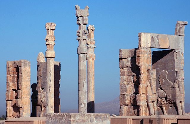
Achaemenid architecture is academically classified under Parsian Architecture in terms of its style and design. With the advent of the second Persian Empire, the Sassanid dynasty, revived Achaemenid tradition by construction of dedicated to fire. Persepolis, would take 100 years to complete and would finally be ransacked, despite having ruled over much of the ancient world, Cyrus the Great would design a tomb that depicts extreme simplicity and modesty when compared to those of other ancient kings and rulers. After his death, Cyrus the Greats remains were interred in his city of Pasargadae. The roof of the edifice and indeed the structure, is an elongated limestone pediment, the inside of the edifice is occupied by a small chamber a few feet in width and height, and around ten feet deep. It was inside this chamber where the bed and coffin of Cyrus the Great would have been situated, the edifice has a pediment roof possessing the same length and width dimensions as the edifice itself. Around the tomb were a series of columns, the structure which they supported is no longer present. There was originally a golden coffin inside the mausoleum, resting on a table with golden supports, the magi were a group of on-site Zoroastrian observers, located in their separate but attached structure possibly a caravanserai, paid and cared for by the Achaemenid state. The magi were placed in charge of maintenance and also prevention of theft, when Alexander reached the tomb, he was horrified by the manner in which the tomb was treated, and questioned the Magi and put them to court. Regardless, Alexander the Great ordered Aristobulus of Cassandreia to improve the tombs condition, the tomb was originally ornamented with an inscription that, according to Strabo, stated, O man. I am Cyrus the Great, who gave the Persians an empire and was the king of Asia, grudge me not therefore this monument. The edifice has survived the test of time for some 2,500 years, the Persians renamed the tomb, and presented it to the invading army as the tomb of King Solomons mother. It is likely that the inscription was lost at this time, Mohammad Reza Pahlavi, the last official monarch of Persia, during his 2,500 year celebration of the Persian Empire paid significant homage to the Achaemenid kings and specially Cyrus the Great. Just as Alexander the Great before him, the Shah of Iran wanted to appeal to Cyruss legacy to legitimize his own rule by extension, Shah of Iran however was generally interested in protection of imperial historical artifacts. There are allegations of the tomb being in danger of damage from the construction of the Sivand Dam on river Polvar and water related damage, united Nations recognizes the tomb of Cyrus the Great and Pasargadae as a UNESCO World Heritage site. Persepolis is the Latinized version of the Old Persian name, Parsa literally meaning the city of Persians, another spectacular achievement of the Achaemenids, Persepolis became one of the four capitals of the empire. Initiated by Darius the Great around 518 B. C. E, persepoliss prestige and grand riches were well known in the ancient world, and it was best described by the Greek historian Diodorus Siculus as the richest city under the sun. Today the archaeological remnants of this opulent city are about 70 kilometers northeast of the modern Iranian city of Shiraz, in the Pars province
17.
World Heritage Site
–
A World Heritage Site is a landmark which has been officially recognized by the United Nations, specifically by the United Nations Educational, Scientific and Cultural Organization. Sites are selected on the basis of having cultural, historical, scientific or some form of significance. UNESCO regards these sites as being important to the interests of humanity. The programme catalogues, names, and conserves sites of outstanding cultural or natural importance to the common culture, under certain conditions, listed sites can obtain funds from the World Heritage Fund. The program was founded with the Convention Concerning the Protection of the Worlds Cultural and Natural Heritage, since then,192 state parties have ratified the convention, making it one of the most adhered to international instruments. As of July 2016,1052 sites are listed,814 cultural,203 natural, in 1959, the governments of Egypt and Sudan requested UNESCO to assist their countries to protect and rescue the endangered monuments and sites. In 1960, the Director-General of UNESCO launched an appeal to the Member States for an International Campaign to Save the Monuments of Nubia, the campaign, which ended in 1980, was considered a success. The project cost $80 million, about $40 million of which was collected from 50 countries, the projects success led to other safeguarding campaigns, saving Venice and its lagoon in Italy, the ruins of Mohenjo-daro in Pakistan, and the Borobodur Temple Compounds in Indonesia. UNESCO then initiated, with the International Council on Monuments and Sites, the United States initiated the idea of cultural conservation with nature conservation. The International Union for Conservation of Nature developed similar proposals in 1968, the Convention came into force on 17 December 1975. As of June 2016, it has been ratified by 192 states, including 188 UN member states plus the Cook Islands, the Holy See, Niue, a country must first list its significant cultural and natural sites, the result is called the Tentative List. A country may not nominate sites that have not been first included on the Tentative List, next, it can place sites selected from that list into a Nomination File. The Nomination File is evaluated by the International Council on Monuments and Sites and these bodies then make their recommendations to the World Heritage Committee. There are ten selection criteria – a site must meet at least one of them to be included on the list, up to 2004, there were six criteria for cultural heritage and four criteria for natural heritage. In 2005, this was modified so there is now only one set of ten criteria. Nominated sites must be of outstanding value and meet at least one of the ten criteria. Thus, the Geneva Convention treaty promulgates, Article 53, PROTECTION OF CULTURAL OBJECTS AND OF PLACES OF WORSHIP. There are 1,052 World Heritage Sites located in 165 States Party, of these,814 are cultural,203 are natural and 35 are mixed properties
18.
Shiraz
–
Shiraz is the sixth-most-populous city of Iran and the capital of Fars Province. At the 2011 census, the population of the city was 1,700,665, Shiraz is located in the southwest of Iran on the Roodkhaneye Khoshk seasonal river. It has a climate and has been a regional trade center for over a thousand years. Shiraz is one of the oldest cities of ancient Persia, the earliest reference to the city, as Tiraziš, is on Elamite clay tablets dated to 2000 BC. In the 13th century, Shiraz became a center of the arts and letters, due to the encouragement of its ruler. It was the capital of Persia during the Zand dynasty from 1750 until 1800, two famous poets of Iran, Hafez and Saadi, are from Shiraz, whose tombs are on the north side of the current city boundaries. Shiraz is known as the city of poets, literature, wine and it is also considered by many Iranians to be the city of gardens, due to the many gardens and fruit trees that can be seen in the city, for example Eram Garden. Shiraz has had major Jewish and Christian communities, the crafts of Shiraz consist of inlaid mosaic work of triangular design, silver-ware, pile carpet-weaving and weaving of kilim, called gilim and jajim in the villages and among the tribes. In Shiraz industries such as cement production, sugar, fertilizers, textile products, wood products, metalwork, Shirāz also has a major oil refinery and is also a major center for Irans electronic industries, 53% of Irans electronic investment has been centered in Shiraz. Shiraz is home to Irans first solar power plant, recently the citys first wind turbine has been installed above Babakoohi mountain near the city. The earliest reference to the city is on Elamite clay tablets dated to 2000 BCE, found in June 1970, the tablets written in ancient Elamite name a city called Tiraziš. Phonetically, this is interpreted as /tiračis/ or /ćiračis/ and this name became Old Persian /širājiš/, through regular sound change comes the modern Persian name Shirāz. The name Shiraz also appears on clay sealings found at a 2nd-century CE Sassanid ruin, by some of the native writers, the name Shiraz has derived from a son of Tahmuras, the third Shāh of the world according to Ferdowsis Shāhnāma. Shiraz is most likely more than 4,000 years old, the name Shiraz is mentioned in cuneiform inscriptions from around 2000 BC found in southwestern corner of the city. According to some Iranian mythological traditions, it was erected by Tahmuras Diveband. The oldest sample of wine in the world, dating to approximately 7,000 years ago, was discovered on clay jars recovered outside of Shiraz, in the Achaemenian era, Shiraz was on the way from Susa to Persepolis and Pasargadae. In Ferdowsis Shāhnāma it has said that Artabanus V, the Parthian Emperor of Iran. Ghasre Abu-Nasr which is originally from Parthian era is situated in this area, during the Sassanid era, Shiraz was in between the way which was connecting Bishapur and Gur to Istakhr
19.
UNESCO
–
The United Nations Educational, Scientific and Cultural Organization is a specialized agency of the United Nations based in Paris. It is the heir of the League of Nations International Committee on Intellectual Cooperation, UNESCO has 195 member states and nine associate members. Most of its offices are cluster offices covering three or more countries, national and regional offices also exist. UNESCO pursues its objectives through five major programs, education, natural sciences, social/human sciences, culture and it is also a member of the United Nations Development Group. UNESCO and its mandate for international cooperation can be traced back to a League of Nations resolution on 21 September 1921, on 18 December 1925, the International Bureau of Education began work as a non-governmental organization in the service of international educational development. However, the work of predecessor organizations was largely interrupted by the onset of World War II. On 30 October 1943, the necessity for an organization was expressed in the Moscow Declaration, agreed upon by China, the United Kingdom, the United States. This was followed by the Dumbarton Oaks Conference proposals of 9 October 1944, a prominent figure in the initiative for UNESCO was Rab Butler, the Minister of Education for the United Kingdom. At the ECO/CONF, the Constitution of UNESCO was introduced and signed by 37 countries, the Preparatory Commission operated between 16 November 1945, and 4 November 1946—the date when UNESCOs Constitution came into force with the deposit of the twentieth ratification by a member state. The first General Conference took place between 19 November to 10 December 1946, and elected Dr. Julian Huxley to Director-General and this change in governance distinguished UNESCO from its predecessor, the CICI, in how member states would work together in the organizations fields of competence. In 1956, the Republic of South Africa withdrew from UNESCO claiming that some of the organizations publications amounted to interference in the racial problems. South Africa rejoined the organization in 1994 under the leadership of Nelson Mandela, UNESCOs early work in the field of education included the pilot project on fundamental education in the Marbial Valley, Haiti, started in 1947. This project was followed by missions to other countries, including, for example. In 1948, UNESCO recommended that Member States should make free primary education compulsory, in 1990, the World Conference on Education for All, in Jomtien, Thailand, launched a global movement to provide basic education for all children, youths and adults. Ten years later, the 2000 World Education Forum held in Dakar, Senegal, UNESCOs early activities in culture included, for example, the Nubia Campaign, launched in 1960. The purpose of the campaign was to move the Great Temple of Abu Simbel to keep it from being swamped by the Nile after construction of the Aswan Dam, during the 20-year campaign,22 monuments and architectural complexes were relocated. This was the first and largest in a series of campaigns including Mohenjo-daro, Fes, Kathmandu, Borobudur, the organizations work on heritage led to the adoption, in 1972, of the Convention concerning the Protection of the World Cultural and Natural Heritage. The World Heritage Committee was established in 1976 and the first sites inscribed on the World Heritage List in 1978, since then important legal instruments on cultural heritage and diversity have been adopted by UNESCO member states in 2003 and 2005
20.
Ancient Greek
–
Ancient Greek includes the forms of Greek used in ancient Greece and the ancient world from around the 9th century BC to the 6th century AD. It is often divided into the Archaic period, Classical period. It is antedated in the second millennium BC by Mycenaean Greek, the language of the Hellenistic phase is known as Koine. Koine is regarded as a historical stage of its own, although in its earliest form it closely resembled Attic Greek. Prior to the Koine period, Greek of the classic and earlier periods included several regional dialects, Ancient Greek was the language of Homer and of fifth-century Athenian historians, playwrights, and philosophers. It has contributed many words to English vocabulary and has been a subject of study in educational institutions of the Western world since the Renaissance. This article primarily contains information about the Epic and Classical phases of the language, Ancient Greek was a pluricentric language, divided into many dialects. The main dialect groups are Attic and Ionic, Aeolic, Arcadocypriot, some dialects are found in standardized literary forms used in literature, while others are attested only in inscriptions. There are also several historical forms, homeric Greek is a literary form of Archaic Greek used in the epic poems, the Iliad and Odyssey, and in later poems by other authors. Homeric Greek had significant differences in grammar and pronunciation from Classical Attic, the origins, early form and development of the Hellenic language family are not well understood because of a lack of contemporaneous evidence. Several theories exist about what Hellenic dialect groups may have existed between the divergence of early Greek-like speech from the common Proto-Indo-European language and the Classical period and they have the same general outline, but differ in some of the detail. The invasion would not be Dorian unless the invaders had some relationship to the historical Dorians. The invasion is known to have displaced population to the later Attic-Ionic regions, the Greeks of this period believed there were three major divisions of all Greek people—Dorians, Aeolians, and Ionians, each with their own defining and distinctive dialects. Often non-west is called East Greek, Arcadocypriot apparently descended more closely from the Mycenaean Greek of the Bronze Age. Boeotian had come under a strong Northwest Greek influence, and can in some respects be considered a transitional dialect, thessalian likewise had come under Northwest Greek influence, though to a lesser degree. Most of the dialect sub-groups listed above had further subdivisions, generally equivalent to a city-state and its surrounding territory, Doric notably had several intermediate divisions as well, into Island Doric, Southern Peloponnesus Doric, and Northern Peloponnesus Doric. The Lesbian dialect was Aeolic Greek and this dialect slowly replaced most of the older dialects, although Doric dialect has survived in the Tsakonian language, which is spoken in the region of modern Sparta. Doric has also passed down its aorist terminations into most verbs of Demotic Greek, by about the 6th century AD, the Koine had slowly metamorphosized into Medieval Greek
21.
Persis
–
Persis, better known as Persia, or Persia proper, was originally a name of a region near the Zagros mountains at Lake Urmia. The country name Persia was derived directly from the Old Persian Parsa, over time, the area of settlement shifted to the southwest of modern Iran. The ruins of Persepolis and Pasargadae, two of the four capitals of the Achaemenid Empire, are located in Fars, the Achaemenid Empire was defeated by Alexander the Great in 333 BC, incorporating most of their vast empire. Shortly after this the Seleucid Empire was established, however it never extended its power beyond the main trade routes in Fars, and by the reign of Antiochus I or possibly later Persis emerged as an independent state that minted its own coins. The Seleucid Empire was subsequently defeated by the Parthians in 238 BC, by 205 BC, Antiochus III had extended his authority into Persis and it ceased to be an independent state. Babak was the ruler of a town called Kheir. Babaks efforts in gaining power at the time escaped the attention of Artabanus IV. Babak and his eldest son Shapur managed to expand their power all of Persis. The subsequent events are unclear, due to the nature of the sources. It is however certain that following the death of Babak around 220, Ardashir who at the time was the governor of Darabgird, the sources tell us that in 222, Shapur was killed when the roof of a building collapsed on him. At this point, Ardashir moved his capital further to the south of Persis, Artabanus marched a second time against Ardashir I in 224. Their armies clashed at Hormizdegan, where Artabanus IV was killed, the Sassanids ruled for 425 years, until the Muslim armies conquered the empire. Afterwards, the Persians started to convert to Islam, this making it easier for the new Muslim empire to continue the expansion of Islam. The ruins of Bishapur, Persepolis, and Firouzabad are all reminders of this, arab invaders brought about a decline of Zoroastrian rule and made Islam ascendant from the 7th century
22.
Late antiquity
–
Late antiquity is a periodization used by historians to describe the time of transition from classical antiquity to the Middle Ages in mainland Europe, the Mediterranean world, and the Near East. The development of the periodization has generally been accredited to historian Peter Brown, precise boundaries for the period are a continuing matter of debate, but Brown proposes a period between the 3rd and 8th centuries AD. Generally, it can be thought of as from the end of the Roman Empires Crisis of the Third Century to, in the East, the early Islamic period, following the Muslim conquests in the mid–7th century. In the West the end was earlier, with the start of the Early Medieval period typically placed in the 6th century, beginning with Constantine the Great, Christianity was made legal in the Empire, and a new capital was founded at Constantinople. The resultant cultural fusion of Greco-Roman, Germanic and Christian traditions formed the foundations of the subsequent culture of Europe, the term Spätantike, literally late antiquity, has been used by German-speaking historians since its popularization by Alois Riegl in the early 20th century. Concurrently, some migrating Germanic tribes such as the Ostrogoths and Visigoths saw themselves as perpetuating the Roman tradition, Constantine confirmed the legalization of the religion through the so-called Edict of Milan in 313, jointly issued with his rival in the East, Licinius. Monasticism was not the only new Christian movement to appear in Late Antiquity, notable in this regard is the topic of the Fifty Bibles of Constantine. Within the recently legitimized Christian community of the 4th century, a division could be distinctly seen between the laity and an increasingly celibate male leadership. Celibate and detached, the clergy became an elite equal in prestige to urban notables. The Late Antique period also saw a transformation of the political and social basis of life in. The later Roman Empire was in a sense a network of cities, archaeology now supplements literary sources to document the transformation followed by collapse of cities in the Mediterranean basin. Burials within the urban precincts mark another stage in dissolution of traditional urbanistic discipline, overpowered by the attraction of saintly shrines, in Roman Britain, the typical 4th- and 5th-century layer of black earth within cities seems to be a result of increased gardening in formerly urban spaces. A similar though less marked decline in population occurred later in Constantinople. In Europe there was also a decline in urban populations. As a whole, the period of antiquity was accompanied by an overall population decline in almost all Europe. Long-distance markets disappeared, and there was a reversion to a degree of local production and consumption, rather than webs of commerce. The degree and extent of discontinuity in the cities of the Greek East is a moot subject among historians. In the western Mediterranean, the new cities known to be founded in Europe between the 5th and 8th centuries were the four or five Visigothic victory cities
23.
Jamshid
–
Jamshid is a mythological figure of Greater Iranian culture and tradition. In tradition and folklore, Jamshid is described as the fourth and this role is already alluded to in Zoroastrian scripture, where the figure appears as Avestan language Yima Yima, and from which the name Jamshid is derived. Jamshid remains a common Iranian and Zoroastrian male name, edward FitzGerald transliterated the name as Jamshyd. In the eastern regions of Greater Iran, Central Asia, the name Jamshid is originally a compound of two parts, Jam and shid, corresponding to the Avestan names Yima and Xšaēta, derived from the proto-Iranian *Yamah Xšaitah. Yamah and the related Sanskrit Yama are interpreted as the twin, perhaps reflecting an Indo-Iranian belief in a primordial Yama, by regular sound changes Avestan Yima became Middle Persian Jam, which was subsequently continued into New Persian. Both Yamas in Iranian and Indian myth guard Hell with the help of two four-eyed dogs, Xšaitah meant bright, shining or radiant and is probably cognate with the Sanskrit word Shrestha. By regular sound changes xšaitah became Persian shēd or shid, in the Western Iranian languages such as Persian, the vowel /ē/ is pronounced as /i/. Consequently, Jamshēd is now pronounced Jamshid in Iran, the suffix -shid is the same as that found in other names such as khorshid. The modern Turkish name Cem is derived from Persian Jam, Persian speakers later adopted this label to distinguish themselves from Arabic speakers. The word ʿajam or ʿajami is still used in parts of the Islamic world to denote languages other than Arabic. However, Yima refuses, and so Ahura Mazda charges him with a different mission, to rule over and nourish the earth and this Yima accepts, and Ahura Mazda presents him with a golden seal and a dagger inlaid with gold. Yima rules as king for three hundred years, and soon the earth was full of men, flocks of birds and herds of animals and he deprived the daevas, who were demonic servants of the evil Ahriman, of wealth, herds and reputation during his reign. Good men, however, lived lives of plenty, and were neither sick nor aged, father and son walked together, each appearing no older than fifteen. Ahura Mazda visits him once more, warning him of this overpopulation, the earth swells and Yima rules for another six hundred years before the same problem occurred once more. Once again he pressed the seal and dagger to the earth and asked the ground to swell up to more men and beasts. Nine hundred years later, the earth was full again, the same solution is employed, the earth swelling again. The next part of the tells of a meeting of Ahura Mazda and the Yazatas in Airyanem Vaejah. Yima attends with a group of the best of mortals, where Ahura Mazda warns him of a catastrophe, O fair Yima
24.
Sasanian Empire
–
The Sasanian Empire was founded by Ardashir I, after the fall of the Parthian Empire and the defeat of the last Arsacid king, Artabanus V. According to a legend, the vexilloid of the Sasanian Empire was the Derafsh Kaviani, in many ways, the Sasanian period witnessed the peak of ancient Iranian civilization. Persia influenced Roman culture considerably during the Sasanian period, the Sasanians cultural influence extended far beyond the empires territorial borders, reaching as far as Western Europe, Africa, China and India. It played a prominent role in the formation of both European and Asian medieval art, much of what later became known as Islamic culture in art, architecture, music and other subject matter was transferred from the Sasanians throughout the Muslim world. Conflicting accounts shroud the details of the fall of the Parthian Empire, the Sassanid Empire was established in Estakhr by Ardashir I. Papak was originally the ruler of a region called Khir, however, by the year 200, he managed to overthrow Gochihr, and appoint himself as the new ruler of the Bazrangids. His mother, Rodhagh, was the daughter of the governor of Pars. Papak and his eldest son Shapur managed to expand their power all of Pars. The subsequent events are unclear, due to the nature of the sources. It is certain, however, that following the death of Papak, Ardashir, sources reveal that Shapur, leaving for a meeting with his brother, was killed when the roof of a building collapsed on him. By the year 208, over the protests of his brothers who were put to death. Once Ardashir was appointed shahanshah, he moved his capital further to the south of Pars, the city, well supported by high mountains and easily defendable through narrow passes, became the center of Ardashirs efforts to gain more power. The city was surrounded by a high, circular wall, probably copied from that of Darabgird, in a second attempt to destroy Ardashir, Artabanus V himself met Ardashir in battle at Hormozgan, where Artabanus V met his death. Following the death of the Parthian ruler, Ardashir I went on to invade the provinces of the now defunct Parthian Empire. Ardashir was aided by the geography of the province of Fars, in the next few years, local rebellions would form around the empire. Nonetheless, Ardashir I further expanded his new empire to the east and northwest, conquering the provinces of Sistan, Gorgan, Khorasan, Margiana, Balkh and he also added Bahrain and Mosul to Sassanids possessions. In the west, assaults against Hatra, Armenia and Adiabene met with less success, in 230, he raided deep into Roman territory, and a Roman counter-offensive two years later ended inconclusively, although the Roman emperor, Alexander Severus, celebrated a triumph in Rome. Ardashir Is son Shapur I continued the expansion of the empire, conquering Bactria, invading Roman Mesopotamia, Shapur I captured Carrhae and Nisibis, but in 243 the Roman general Timesitheus defeated the Persians at Rhesaina and regained the lost territories
25.
Retaining wall
–
Retaining walls are structures designed to restrain soil to a slope that it would not naturally keep to. A retaining wall is a designed and constructed to resist the lateral pressure of soil. A basement wall is one kind of retaining wall. But the term refers to a cantilever retaining wall, which is a freestanding structure without lateral support at its top. These are cantilevered from a footing and rise above the grade on one side to retain a level grade on the opposite side. The walls must resist the pressures generated by loose soils or, in some cases. Every retaining wall supports a “wedge” of soil, the wedge is defined as the soil which extends beyond the failure plane of the soil type present at the wall site, and can be calculated once the soil friction angle is known. As the setback of the wall increases, the size of the wedge is reduced. This reduction lowers the pressure on the retaining wall, the most important consideration in proper design and installation of retaining walls is to recognize and counteract the tendency of the retained material to move downslope due to gravity. Lateral earth pressures are zero at the top of the wall, earth pressures will push the wall forward or overturn it if not properly addressed. Also, any groundwater behind the wall that is not dissipated by a system causes hydrostatic pressure on the wall. The total pressure or thrust may be assumed to act at one-third from the lowest depth for lengthwise stretches of uniform height. Unless the wall is designed to retain water, It is important to have proper drainage behind the wall in order to limit the pressure to the design value. Drainage materials will reduce or eliminate the pressure and improve the stability of the material behind the wall. Drystone retaining walls are normally self-draining.5 against lateral sliding and overturning, gravity walls depend on their mass to resist pressure from behind and may have a batter setback to improve stability by leaning back toward the retained soil. For short landscaping walls, they are made from mortarless stone or segmental concrete units. Dry-stacked gravity walls are somewhat flexible and do not require a rigid footing, earlier in the 20th century, taller retaining walls were often gravity walls made from large masses of concrete or stone. Cantilevered retaining walls are made from a stem of steel-reinforced
26.
Cyrus the Great
–
Cyrus II of Persia, commonly known as Cyrus the Great and also called Cyrus the Elder by the Greeks, was the founder of the Achaemenid Empire. From the Mediterranean Sea and Hellespont in the west to the Indus River in the east, under his successors, the empire eventually stretched at its maximum extent from parts of the Balkans and Eastern Europe proper in the west, to the Indus Valley in the east. His regal titles in full were The Great King, King of Persia, King of Anshan, King of Media, King of Babylon, King of Sumer and Akkad, the reign of Cyrus the Great lasted between 29 and 31 years. Cyrus built his empire by conquering first the Median Empire, then the Lydian Empire, either before or after Babylon, he led an expedition into central Asia, which resulted in major campaigns that were described as having brought into subjection every nation without exception. Cyrus did not venture into Egypt, as he died in battle. He was succeeded by his son, Cambyses II, who managed to add to the empire by conquering Egypt, Nubia, Cyrus the Great respected the customs and religions of the lands he conquered. This became a successful model for centralized administration and establishing a government working to the advantage. In fact, the administration of the empire through satraps and the principle of forming a government at Pasargadae were the works of Cyrus. Cyrus the Great is also recognized for his achievements in human rights, politics. Having originated from Persis, roughly corresponding to the modern Iranian province of Fars and this view has been criticized by some historians as a misunderstanding of the Cylinders generic nature as a traditional statement that new monarchs make at the beginning of their reign. The name Cyrus is a Latinized form derived from the Greek Κῦρος, Kỹros, the name and its meaning has been recorded in ancient inscriptions in different languages. This may also point to a relationship to the mythological first king of Persia, Jamshid. Karl Hoffmann has suggested a translation based on the meaning of an Indo-European-root to humiliate, in the Persian language and especially in Iran, Cyruss name is spelled as کوروش. In the Bible, he is known as Koresh, the Persian domination and kingdom in the Iranian plateau started by an extension of the Achaemenid dynasty, who expanded their earlier domination possibly from the 9th century BC onward. The eponymous founder of dynasty was Achaemenes. Achaemenids are descendants of Achaemenes as Darius the Great, the king of the dynasty, traces his genealogy to him. Ancient documents mention that Teispes had a son called Cyrus I, Cyrus I had a full brother whose name is recorded as Ariaramnes. In 600 BC, Cyrus I was succeeded by his son, Cambyses I, Cyrus the Great was a son of Cambyses I, who named his son after his father, Cyrus I
27.
Susa
–
Susa was an ancient city of the Proto-Elamite, Elamite, First Persian Empire, Seleucid, and Parthian empires of Iran, and one of the most important cities of the Ancient Near East. It is located in the lower Zagros Mountains about 250 km east of the Tigris River, the modern Iranian town of Shush is located at the site of ancient Susa. Shush is the capital of the Shush County of Irans Khuzestan province. It had a population of 64,960 in 2005, in Elamite, the name of the city was written variously Ŝuŝan, Ŝuŝun, etc. The origin of the word Susa is from the city deity Inshushinak. Susa was one of the most important cities of the Ancient Near East, Susa is also mentioned in the Ketuvim of the Hebrew Bible by the name Shushan, mainly in Esther, but also once each in Nehemiah and Daniel. Both Daniel and Nehemiah lived in Susa during the Babylonian captivity of the 6th century BCE, Esther became queen there, married to King Ahasueurus, and saved the Jews from genocide. A tomb presumed to be that of Daniel is located in the area, however, the current structure is actually a much later construction dated to the late nineteenth century, ca. Susa is further mentioned in the Book of Jubilees as one of the places within the inheritance of Shem and his eldest son Elam, Greek mythology attributed the founding of Susa to king Memnon of Aethiopia, a character from Homers Trojan War epic, the Iliad. The site was examined in 1836 by Henry Rawlinson and then by A. H. Layard, in 1851, some modest excavation was done by William Loftus, who identified it as Susa. In 1885 and 1886 Marcel-Auguste Dieulafoy and Jane Dieulafoy began the first French excavations, jacques de Morgan conducted major excavations from 1897 until 1911. These efforts continued under Roland De Mecquenem until 1914, at the beginning of World War I, French work at Susa resumed after the war, led by De Mecquenem, continuing until World War II in 1940. Archaeological results from the period were very thinly published and attempts are underway to remedy this situation. Roman Ghirshman took over direction of the French efforts in 1946, together with his wife Tania Ghirshman, he continued there until 1967. The Ghirshmans concentrated on excavating a single part of the site, the pottery found at the various levels enabled a stratigraphy to be developed for Susa. During the 1970s, excavations resumed under Jean Perrot, archeologists have dated the first traces of an inhabited Neolithic village to c 7000 BCE. Evidence of a civilization has been dated to c 5000 BCE. Painted ceramic vessels from Susa in the earliest first style are a late, in urban history, Susa is one of the oldest-known settlements of the region
28.
Babylon
–
Babylon was a major city of ancient Mesopotamia in the fertile plain between the Tigris and Euphrates rivers. The city was built upon the Euphrates and divided in parts along its left and right banks. Babylon was originally a small Semitic Akkadian city dating from the period of the Akkadian Empire c.2300 BC, the town attained independence as part of a small city-state with the rise of the First Amorite Babylonian Dynasty in 1894 BC. Babylon grew and South Mesopotamia came to be known as Babylonia, the empire quickly dissolved after Hammurabis death and Babylon spent long periods under Assyrian, Kassite and Elamite domination. After being destroyed and then rebuilt by the Assyrians, Babylon became the capital of the Neo-Babylonian Empire from 609 to 539 BC, the Hanging Gardens of Babylon was one of the Seven Wonders of the Ancient World. After the fall of the Neo-Babylonian Empire, the city came under the rule of the Achaemenid, Seleucid, Parthian, Roman, and Sassanid empires. It has been estimated that Babylon was the largest city in the world from c.1770 to 1670 BC and it was perhaps the first city to reach a population above 200,000. Estimates for the extent of its area range from 890 to 900 hectares. The remains of the city are in present-day Hillah, Babil Governorate, Iraq, about 85 kilometres south of Baghdad, comprising a large tell of broken mud-brick buildings, the English Babylon comes from Greek Babylṓn, a transliteration of the Akkadian Babili. The Babylonian name in the early 2nd millennium BC had been Babilli or Babilla, by the 1st millennium BC, it had changed to Babili under the influence of the folk etymology which traced it to bāb-ili. The Gate of God or Gate of El being from the Aramaic Hebrew Bab for Gate and El for God and this being similar to the Hebrew word for confusion Balal. In the Bible, the name appears as Babel, interpreted in the Hebrew Scriptures Book of Genesis to mean confusion, the modern English verb, to babble, or to speak meaningless words, is popularly thought to derive from this name, but there is no direct connection. The remains of the city are in present-day Hillah, Babil Governorate, Iraq, about 85 kilometers south of Baghdad, comprising a large tell of broken mud-brick buildings and debris. The site at Babylon consists of a number of mounds covering an area of about 2 by 1 kilometer, oriented north to south, along the Euphrates to the west. Originally, the river roughly bisected the city, but the course of the river has since shifted so that most of the remains of the western part of the city are now inundated. Some portions of the city wall to the west of the river also remain, remains of the city include, Kasr—also called Palace or Castle, it is the location of the Neo-Babylonian ziggurat Etemenanki and lies in the center of the site. Amran Ibn Ali—the highest of the mounds at 25 meters, to the south and it is the site of Esagila, a temple of Marduk which also contained shrines to Ea and Nabu. Homera—a reddish colored mound on the west side, most of the Hellenistic remains are here
29.
Ecbatana
–
Ecbatana was an ancient city in Media in western Iran. It is believed that Ecbatana is in Tell Hagmatana, near Hamedan, but the history of the city is controversial. Excavations at Kaboutar Ahang have revealed stone age tools and pottery from 1400 to 1200 BC, according to Herodotus, Ecbatana was chosen as the Medes capital in the late 8th century BC by Deioces. Under the Persian kings, Ecbatana, situated at the foot of Mount Alvand, later, it became the capital of the Parthian kings, at which time it became their main mint, producing drachm, tetradrachm, and assorted bronze denominations. It is also mentioned in the Hebrew Bible under the name Achmetha, in 330 BC, Ecbatana was the site of the murder of the Macedonian general Parmenion by order of Alexander the Great. Ecbatana was first excavated in 1913 by Charles Fossey, another excavation was conducted in 1977. The Greeks thought Ecbatana to be the capital of Medes empire and it is alleged that he surrounded his palace in Ecbatana with seven concentric walls of different colours. In the 5th century BC, Herodotus wrote of Ecbatana, The Medes built the city now called Ecbatana, the plan of the place is, that each of the walls should out-top the one beyond it by the battlements. The nature of the ground, which is a hill, favors this arrangements in some degree. The number of the circles is seven, the royal palace, the circuit of the outer wall is very nearly the same with that of Athens. On this wall the battlements are white, of the black, of the third scarlet, of the fourth blue. The last two have their battlements coated respectively with silver and gold, all these fortifications Deioces had caused to be raised for himself and his own palace. There is currently no evidence of Median existence in Hagmatana hill prior to the Parthian era afterwards, similarly, Assyrian sources never mention Hagmatana/Ecbatana. The Sagbita mentioned by Assyrian sources was located in the proximity of the cities Kishesim, sir Henry Rawlinson attempted to prove that there was a second and older Ecbatana in Media Atropatene on the site of the modern Takht-i-Suleiman. However, the cuneiform texts imply that there was one city of the name. Ecbatana is the capital of Astyages, which was taken by the Persian emperor Cyrus the Great in the sixth year of Nabonidus. Inscribed Column Bases from Hamadan, Iran, vol,39, pp. 99–117,2001 This article incorporates text from a publication now in the public domain, Chisholm, Hugh, ed. article name needed
30.
Alexander the Great
–
Alexander III of Macedon, commonly known as Alexander the Great, was a king of the Ancient Greek kingdom of Macedon and a member of the Argead dynasty. He was born in Pella in 356 BC and succeeded his father Philip II to the throne at the age of twenty and he was undefeated in battle and is widely considered one of historys most successful military commanders. During his youth, Alexander was tutored by Aristotle until the age of 16, after Philips assassination in 336 BC, he succeeded his father to the throne and inherited a strong kingdom and an experienced army. Alexander was awarded the generalship of Greece and used this authority to launch his fathers Panhellenic project to lead the Greeks in the conquest of Persia, in 334 BC, he invaded the Achaemenid Empire and began a series of campaigns that lasted ten years. Following the conquest of Anatolia, Alexander broke the power of Persia in a series of battles, most notably the battles of Issus. He subsequently overthrew Persian King Darius III and conquered the Achaemenid Empire in its entirety, at that point, his empire stretched from the Adriatic Sea to the Indus River. He sought to reach the ends of the world and the Great Outer Sea and invaded India in 326 BC and he eventually turned back at the demand of his homesick troops. Alexander died in Babylon in 323 BC, the city that he planned to establish as his capital, without executing a series of planned campaigns that would have begun with an invasion of Arabia. In the years following his death, a series of civil wars tore his empire apart, resulting in the establishment of several states ruled by the Diadochi, Alexanders surviving generals, Alexanders legacy includes the cultural diffusion which his conquests engendered, such as Greco-Buddhism. He founded some twenty cities that bore his name, most notably Alexandria in Egypt, Alexander became legendary as a classical hero in the mold of Achilles, and he features prominently in the history and mythic traditions of both Greek and non-Greek cultures. He became the measure against which military leaders compared themselves, and he is often ranked among the most influential people in human history. He was the son of the king of Macedon, Philip II, and his wife, Olympias. Although Philip had seven or eight wives, Olympias was his wife for some time. Several legends surround Alexanders birth and childhood, sometime after the wedding, Philip is said to have seen himself, in a dream, securing his wifes womb with a seal engraved with a lions image. Plutarch offered a variety of interpretations of dreams, that Olympias was pregnant before her marriage, indicated by the sealing of her womb. On the day Alexander was born, Philip was preparing a siege on the city of Potidea on the peninsula of Chalcidice. That same day, Philip received news that his general Parmenion had defeated the combined Illyrian and Paeonian armies, and it was also said that on this day, the Temple of Artemis in Ephesus, one of the Seven Wonders of the World, burnt down. This led Hegesias of Magnesia to say that it had burnt down because Artemis was away, such legends may have emerged when Alexander was king, and possibly at his own instigation, to show that he was superhuman and destined for greatness from conception
31.
Cistern
–
A cistern is a waterproof receptacle for holding liquids, usually water. Cisterns are often built to catch and store rainwater, cisterns are distinguished from wells by their waterproof linings. Modern cisterns range in capacity from a few litres to thousands of cubic metres, in the Middle Ages, cisterns were often constructed in hill castles in Europe, especially where wells could not be dug deeply enough. There were two types, the cistern and the filter cistern. Such a filter cistern was built at the Riegersburg in Austrian Styria, rain water passed through a sand filter and collected in the cistern. The filter cleaned the water and enriched it with minerals. Cisterns are commonly prevalent in areas where water is scarce, either because it is rare or has been depleted due to heavy use, early on, the water was used for many purposes including cooking, irrigation, and washing. Present day cisterns are often used only for irrigation due to concerns over water quality, cisterns today can also be outfitted with filters or other water purification methods when the water is intended for consumption. It is not uncommon for a cistern to be open in some manner in order to rain or to include more elaborate rainwater harvesting systems. It is important in cases to have a system that does not leave the water open to algae or to mosquitoes. Some cisterns sit on the top of houses or on the higher than the house. They are often supplied not by rainwater harvesting, but by wells with electric pumps, modern cisterns are manufactured of plastic. To keep a clean water supply, the cistern must be kept clean and it is important to inspect them regularly, keep them well enclosed, and to occasionally empty and clean them with a proper dilution of chlorine and to rinse them well. Well water must be inspected for contaminants coming from the ground source, city water has up to 1ppm chlorine added to the water to keep it clean, and in many areas can be ordered to be delivered directly to the cistern by truck. If there is any question about the supply at any point. Water of non-acceptable quality for the aforementioned uses may still be used for irrigation, if it is free of particulates but not low enough in bacteria, then boiling may also be an effective method to prepare the water for drinking. Many greenhouses rely on a cistern to help meet their water needs, other countries, such as Japan, Germany, and Spain, also offer financial incentives or tax credit for installing cisterns. Cisterns may also be used to water for firefighting in areas where there is an inadequate water supply
32.
Diodorus Siculus
–
Diodorus Siculus or Diodorus of Sicily was a Greek historian. He is known for writing the monumental universal history Bibliotheca historica, much of which survives and it is arranged in three parts. The first covers mythic history up to the destruction of Troy, arranged geographically, describing regions around the world from Egypt, India and Arabia to Greece, the second covers the Trojan War to the death of Alexander the Great. The third covers the period to about 60 BC, Bibliotheca, meaning library, acknowledges that he was drawing on the work of many other authors. According to his own work, he was born at Agyrium in Sicily, with one exception, antiquity affords no further information about his life and doings beyond in his work. Only Jerome, in his Chronicon under the year of Abraham 1968, writes, Diodorus of Sicily and it was divided into three sections. In the next section, he recounts the history of the world from the Trojan War down to the death of Alexander the Great, the last section concerns the historical events from the successors of Alexander down to either 60 BC or the beginning of Julius Caesars Gallic Wars. He selected the name Bibliotheca in acknowledgment that he was assembling a composite work from many sources. His account of gold mining in Nubia in eastern Egypt is one of the earliest extant texts on the topic, pappus of Alexandria wrote a Commentary on Diodoruss Analemma. The now lost Analemma applied geometrical constructions in a plane to solve some astronomy related problems of spherical geometry and it contained, for example, a discussion of sundial theory. They are also boasters and threateners and are fond of pompous language, pliny the Elder Strabo Acadine Ambaglio, Dino, Franca Landucci Gattinoni and Luigi Bravi. Diodoro Siculo, Biblioteca storica, commento storico, introduzione generale, aspects of Greek History 750-323 BC, A Source-based Approach. Library of History, Loeb Classical Library, Siculus, Diodorus, G. Booth, H. Valesius, I. The Historical Library of Diodorus the Sicilian in Fifteen Books to which are added the Fragments of Diodorus, siculi, Diodori, Peter Wesseling, L. Rhodoman, G. Heyn, N. Eyring. Bibliothecae Historicae Libri Qui Supersunt, Nova Editio, Diodorus Siculus, the manuscripts of the Bibliotheca Historica
33.
Equinox
–
An equinox is the moment in which the plane of Earths equator passes through the center of the Sun, which occurs twice each year, around 20 March and 23 September. On an equinox, day and night are of equal duration all over the planet. They are not exactly equal, however, due to the size of the sun. To avoid this ambiguity, the word equilux is sometimes used to mean a day in which the durations of light, see Length of equinoctial day and night for further discussion. The word is derived from the Latin aequinoctium, aequus and nox, the equinoxes are the only times when the solar terminator is perpendicular to the equator. As a result, the northern and southern hemispheres are equally illuminated, the word comes from Latin equi or equal and nox meaning night. In other words, the equinoxes are the times when the subsolar point is on the equator. The subsolar point crosses the equator moving northward at the March equinox, the equinoxes, along with solstices, are directly related to the seasons of the year. In the southern hemisphere, the equinox occurs in September. When Julius Caesar established the Julian calendar in 45 BC, he set 25 March as the date of the spring equinox. Because the Julian year is longer than the tropical year. By 1500 AD, it had drifted backwards to 11 March and this drift induced Pope Gregory XIII to create a modern Gregorian calendar. However, the leap year intervals in his calendar were not smooth and this causes the equinox to oscillate by about 53 hours around its mean position. This in turn raised the possibility that it could fall on 22 March, the astronomers chose the appropriate number of days to omit so that the equinox would swing from 19 to 21 March but never fall on the 22nd. Vernal equinox and Autumnal equinox, these names are direct derivatives of Latin. The equivalent common language English terms spring equinox and autumn equinox are even more ambiguous, March equinox and September equinox, names referring to the months of the year they occur, with no ambiguity as to which hemisphere is the context. They are still not universal, however, as not all use a solar-based calendar where the equinoxes occur every year in the same month. Northward equinox and southward equinox, names referring to the apparent direction of motion of the Sun
34.
Wars of Alexander the Great
–
Alexander the Great was one of the most successful military commanders of all time. By the time of his death, he had conquered most of the known to the ancient Greeks. Although being successful as a commander, he failed to provide any stable alternative to the Achaemenid Empire—his untimely death threw the vast territories he conquered into civil war. His conquests included Anatolia, Syria, Phoenicia, Judea, Gaza, Egypt, Bactria, and Mesopotamia, Alexander had already made more plans prior to his death for military and mercantile expansions into the Arabian Peninsula, after which he was to turn his armies to the west. However, Alexanders diadochi quietly abandoned these plans after his death. Instead, within a few years of Alexanders death, the diadochi began fighting each other. Philip II was assassinated by the captain of his bodyguard, Pausanias, Philips son, and previously designated heir, Alexander was proclaimed king by the Macedonian noblemen and army. News of Philips death roused many states into revolt including Thebes, Athens, Thessaly, when news of the revolt reached Alexander he responded quickly. Though his advisers counseled him to use diplomacy, Alexander mustered the Macedonian cavalry of 3,000 men and rode south towards Thessaly, Macedons immediate neighbor to the south. When he found the Thessalian army occupying the pass between Mount Olympus and Mount Ossa, he had the men ride through Mount Ossa and, the Thessalians surrendered and added their cavalry to Alexanders force as he rode down towards the Peloponnese. Alexander stopped at Thermopylae, where he was recognized as the leader of the Sacred League before heading south to Corinth, Athens sued for peace and Alexander received the envoy and pardoned anyone involved with the uprising. At Corinth, he was given the title Hegemon of the Greek forces against the Persians, while at Corinth, he heard the news of the Thracian rising in the north. Before crossing to Asia, Alexander wanted to safeguard his northern borders and, in the spring of 335 BC, he advanced into Thrace to deal with the revolt, at Mount Haemus, the Macedonian army attacked and defeated a Thracian garrison manning the heights. The Macedonians were then attacked in the rear by the Triballi, Alexander then advanced on to the Danube, encountering the Getae tribe on the opposite shore. The Getae army retreated after the first cavalry skirmish, leaving their town to the Macedonian army, news then reached Alexander that Cleitus, King of Illyria, and King Glaukias of the Taulanti were in open revolt against Macedonian authority. Alexander defeated each in turn, forcing Cleitus and Glaukias to flee with their armies, while he was triumphantly campaigning north, the Thebans and Athenians rebelled once more. Alexander reacted immediately, but, while the other once again hesitated. This resistance was useless, however, as the city was razed to the ground amid great bloodshed, the end of Thebes cowed Athens into submission, leaving all of Greece at least outwardly at peace with Alexander
35.
Royal Road
–
The Royal Road was an ancient highway reorganized and rebuilt by the Persian king Darius the Great of the first Persian Empire in the 5th century BCE. Darius built the road to facilitate rapid communication throughout his very large empire from Susa to Sardis, mounted couriers of the Angarium could travel 1677 miles in seven days, the journey from Susa to Sardis took ninety days on foot. The Greek historian Herodotus wrote, There is nothing in the world that travels faster than these Persian couriers, the course of the road has been reconstructed from the writings of Herodotus, archeological research, and other historical records. Of course, such routes for travellers and tradesmen would often take months on end. This route was used by couriers to deliver messages to the Persian capital, however, Darius I improved the existing road network into the Royal Road as it is recognized today. A later improvement by the Romans of a bed with a hard-packed gravelled surface of 6. The construction of the road as improved by Darius was of quality that the road continued to be used until Roman times. A bridge at Diyarbakır, Turkey, still stands from this period of the roads use, the road also helped Persia increase long-distance trade, which reached its peak during the time of Alexander the Great. In 1961, under a grant from the American Philosophical Society, S. F. Starr traced the stretch of road from Gordium to Sardis, identifying river crossings by ancient bridge abutments. Euclid is said to have replied to King Ptolemys request for a way of learning mathematics that there is no Royal Road to geometry. Charles Sanders Peirce, in his How to Make Our Ideas Clear, says, There is no road to logic. This essay was claimed by William James as instrumental in the foundation of the school of pragmatism. Sigmund Freud famously described dreams as the road to the unconscious. The Royal Road to Romance is the first book by Richard Halliburton, boston, MA, Houghton Mifflin Company,2008. The History of Iran on Iran Chamber Society, archived from the original on February 16,2014
36.
Battle of the Persian Gate
–
In the winter of 330 BC, Ariobarzanes led a last stand of the outnumbered Persian forces at the Persian Gates near Persepolis, holding the Macedonian army for a month. Alexander eventually found a path to the rear of the Persians from the prisoners of war or a local shepherd. The Persian Empire suffered a series of defeats against the Macedonian forces at Issus and Gaugamela, a Royal Road connected Susa with the more eastern capitals of Persepolis and Pasargadae in Persis, and was the natural venue for Alexanders continued campaign. Meanwhile, King Darius III was building a new army at Ecbatana, Ariobarzanes was charged with preventing the Macedonian advance into Persis, and to this effect he relied heavily on the terrain Alexander needed to pass through. There were only a few routes through the Zagros Mountains. After the conquest of Susa, Alexander split the Macedonian army into two parts, Alexanders general, Parmenion, took one half along the Royal Road, and Alexander himself took the route towards Persis. Passing into Persis required traversing the Persian Gates, a mountain pass that lent itself easily to ambush. During his advance, Alexander subdued the Uxians, a local hill-tribe which had demanded the tribute from him they used to receive from the Persian kings for safe passage. As he passed into the Persian Gates he met no resistance. Believing that he would not encounter any enemy forces during his march, Alexander neglected to send scouts ahead of his vanguard. The valley preceding the Persian Gate, called the Tange Meyran, is very wide. Ariobarzanes occupied a position near the village of Cheshmeh Chenar. The road curves to the southeast and narrows considerably at that point, according to historian Arrian, Ariobarzanes had a force of 40,000 infantry and 700 cavalry who faced a Macedonian force of over 10,000. Encyclopædia Iranica suggests a number of defenders of just 700 men, the Persian Gate was only a couple of meters wide at the point of ambush. Once the Macedonian army had advanced sufficiently into the narrow pass, from the southern slope, Persian archers launched their projectiles. Alexanders army initially suffered heavy casualties, losing entire platoons at a time, the Macedonians attempted to withdraw, but the terrain and their still-advancing rear guard made an orderly retreat impossible. Alexander was forced to leave his dead behind to save the rest of his army—a great mark of disgrace to the Greeks and Macedonians who valued highly the recovery, Ariobarzanes had some reason to believe that success here could change the course of the war. Ariobarzanes held the pass for a month, but Alexander succeeded in encircling the Persians in an attack with Philotas
37.
Zagros Mountains
–
The Zagros Mountains form the largest mountain range in Iran, Iraq and southeastern Turkey. This mountain range has a length of 1,500 km. The highest point in the Zagros Mountains is Dena, the Zagros fold and thrust belt was formed by collision of two tectonic plates, the Eurasian Plate and the Arabian Plate. This collision primarily happened during the Miocene and folded the rocks that had been deposited from the Carboniferous to the Miocene in the geosyncline in front of the Iranian Plate. The process of collision continues to the present and as the Arabian Plate is being pushed against the Eurasian Plate, the Zagros Mountains, a relatively dense GPS network which covered the Iranian Zagros also proves a high rate of deformation within the Zagros. The GPS results show that the current rate of shortening in the southeast Zagros is ~10 mm/yr, the north-south Kazerun strike-slip fault divides the Zagros into two distinct zones of deformation. The GPS results also show different shortening directions along the belt, normal shortening in the southeast, the sedimentary cover in the SE Zagros is deforming above a layer of rock salt whereas in the NW Zagros the salt layer is missing or is very thin. This different basal friction is partly responsible for the different topographies on either side of the Kazerun fault. Higher topography and narrower zone of deformation in the NW Zagros is observed whereas in the SE, deformation was spread more, stresses induced in the Earths crust by the collision caused extensive folding of the preexisting layered sedimentary rocks. Subsequent erosion removed softer rocks, such as mudstone and siltstone while leaving harder rocks, such as limestone and this differential erosion formed the linear ridges of the Zagros Mountains. The depositional environment and tectonic history of the rocks were conducive to the formation and trapping of petroleum, salt domes and salt glaciers are a common feature of the Zagros Mountains. Salt domes are an important target for exploration, as the impermeable salt frequently traps petroleum beneath other rock layers. The Zagros Mountains have a totally sedimentary origin and are primarily of limestone. In the Elevated Zagros or the Higher Zagros, the Paleozoic rocks could be found mainly in the upper and higher sections of the peaks of the Zagros Mountains along the Zagros main fault. On the both sides of this fault, there are Mesozoic rocks, a combination of Triassic and Jurassic rocks that are surrounded by Cretaceous rocks on the both sides. The Folded Zagros is formed mainly of Tertiary rocks, with the Paleogene rocks south of the Cretaceous rocks, the mountains are divided into many parallel sub-ranges, and orogenically have the same age as the Alps. Irans main oilfields lie in the central foothills of the Zagros mountain range. The southern ranges of the Fars Province have somewhat lower summits and they contain some limestone rocks showing abundant marine fossils
38.
Ariobarzanes of Persis
–
Satrap or Satrapes, derived from Old Persian xsatrapa, means the Protector of the Land, and it was the name given to the provincial governors in the ancient Achaemenid Empire. Darius I or Darius the Great established 20 satraps with an annual tribute, appointed by the king, satraps were usually of the royal family or Iranian nobility and held office indefinitely. They collected taxes, were the highest judicial authority, and were responsible for internal security, after the fall of Achaemenid Empire, Alexander the Great and his successors retained the satraps. Though the exact birth-date of Ariobarzanes is unknown, it is speculated that he was born around 368 BC and his sister was the ancient Persian noblewoman and warrior, Youtab. Ariobarzanes was made satrap of Persis in 335 BC by Darius III, historians are surprised that Darius III Codomannus had appointed a satrap for Persepolis and Persis. It seems that previously, this office did not exist, Ariobarzanes commanded part of the Persian Army fighting against the Macedonians at Gaugamela in 331 BC. Following the Persian defeat at Gaugamela, Darius III realized he could not defend his capital Persepolis and travelled east to rebuild his armies, meanwhile, Alexander the Great split his army and led his 14, 000-strong force towards the Persian capital via the Persian Gates. There Ariobarzanes successfully ambushed Alexander the Greats army, inflicting heavy casualties, the Persian success at the Battle of the Persian Gate was short lived though, after being held off for 30 days, Alexander the Great outflanked and destroyed the defenders. Ariobarzanes himself was killed either during the battle or during the retreat to Persepolis, some sources indicate that the Persian were betrayed by a captured tribal chief who showed the Macedonians an alternate path that allowed them to outflank Ariobarzanes in a reversal of Thermopylae. Battle of the Persian Gate Ariobarzanes of Persis by Nabil Rastani Ariobarzanes, pharnabazus, The Columbia Encyclopedia, Sixth Edition 2006. King Darius III, A Research Article on Darius-III Codomannus Gabae, Persian Gates, Photos of the battlefield