Port Hills
Videos
The Port Hills are a range of hills in Canterbury Region of New Zealand, so named because they lie between the city of Christchurch and its port at Lyttelton. They are an eroded remnant of the Lyttelton volcano, which erupted millions of years ago.

A portion of the Port Hills

A model of the Banks Peninsula (vertically exaggerated); the Port Hills are the volcanic ridge on the left

Kennedy's Bush Scenic Reserve
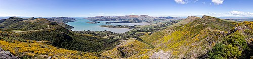
Panoramic view of Port Hills from Mt Ada
Banks Peninsula
Videos
Banks Peninsula is a peninsula of volcanic origin on the east coast of the South Island of New Zealand. It has an area of approximately 1,150 square kilometres (440 sq mi) and encompasses two large harbours and many smaller bays and coves. The South Island's largest city, Christchurch, is immediately north of the peninsula.

Banks Peninsula and Christchurch, in a 2021 NASA satellite photo

Banks Peninsula, with Lyttelton Harbour / Whakaraupō on the right and Lake Ellesmere / Te Waihora in the background

European ships, possibly French, in Akaroa in the early 19th century

Akaroa Harbour, Banks Peninsula with storm clouds overhead (December 2020)