Rumelihisarı
Videos
Photos
Rumelihisarı or Boğazkesen Fortress is a medieval Ottoman fortress located in Istanbul, Turkey, on a series of hills on the European banks of the Bosphorus. The fortress also lends its name to the immediate neighborhood around it in the city's Sarıyer district.

Rumelihisarı as seen from Bosphorus strait

Rumelihisarı as seen from the Bosphorus.

General view from Rumelihisarı, with the Fatih Sultan Mehmet Bridge in the background.

Plan
Bosporus
Videos
Photos
The Bosporus or Bosphorus Strait is a natural strait and an internationally significant waterway located in Istanbul, Turkey. The Bosporus connects the Black Sea to the Sea of Marmara and forms one of the continental boundaries between Asia and Europe. It also divides Turkey by separating Anatolia from Thrace. It is the world's narrowest strait used for international navigation.
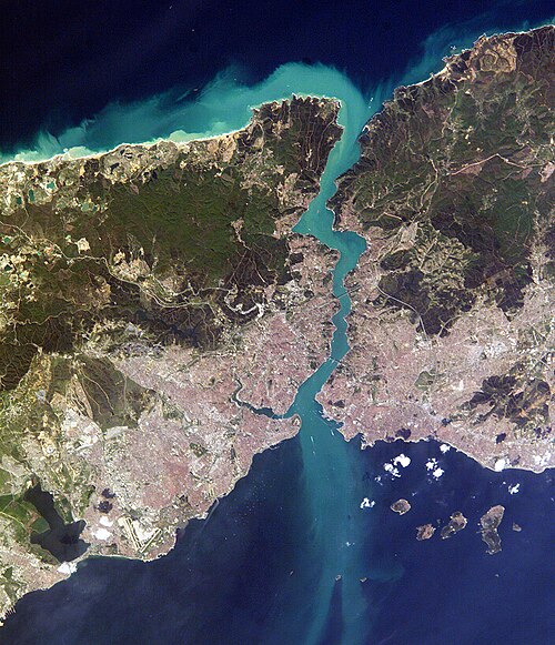
Close-up satellite image of the Bosporus strait, taken from the International Space Station in April 2004. The body of water at the top is the Black Sea, the one at the bottom is the Marmara Sea, and the Bosporus is the winding waterway that connects the two. The western banks of the Bosporus constitute the geographic starting point of the European continent, while the banks to the east are the geographic beginnings of the continent of Asia. The city of
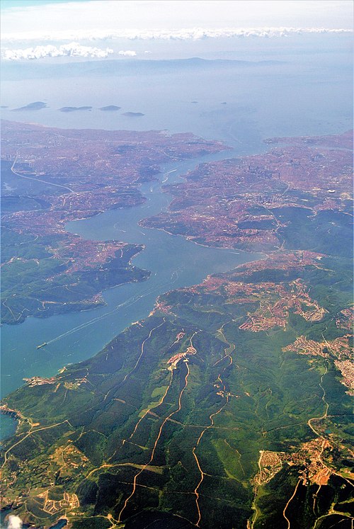
Aerial view of the Bosporus taken from its northern end near the Black Sea (bottom), looking south (top) toward the Marmara Sea, with the city center of Istanbul visible along the strait's hilly banks

The Bosphorus, with the Castles of Europe & Asia. 19th-century engraving by Thomas Allom. The castles are Rumelihisarı and Anadoluhisarı, respectively. The original is a watercolor available in the online collection of the Victoria and Albert Museum.

Modern (2012) view of the European side of Istanbul from the southern entrance to the Bosporus