Sandfly Bay is a sandy bay with large dunes 15 kilometres (9.3 mi) east of central Dunedin, New Zealand. Located on the southern side of Otago Peninsula, between Seal Point and the Gull Rocks on the western side of Sandymount, Sandfly Bay is a Department of Conservation wildlife reserve frequented by trampers.
Sandfly Bay from Seal Point Road, looking east. Lion's Head Rock is clearly visible to the right of centre (May, 2007)
Pacific coast of Otago Peninsula seen from St Clair, New Zealand. Lion's Head Rock is clearly visible behind the long, low-lying form of Bird Island.
Sea lions in Sandfly Bay
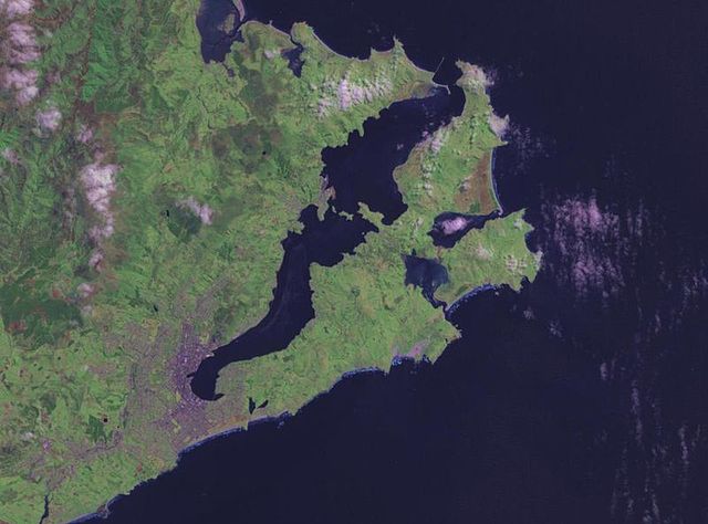
The Otago Peninsula is a long, hilly indented finger of land that forms the easternmost part of Dunedin, New Zealand. Volcanic in origin, it forms one wall of the eroded valley that now forms Otago Harbour. The peninsula lies south-east of Otago Harbour and runs parallel to the mainland for 20 km, with a maximum width of 9 km. It is joined to the mainland at the south-west end by a narrow isthmus about 1.5 km wide.
NASA satellite photo of Otago Peninsula and Otago Harbour. The city of Dunedin is located at the isthmus at lower left.
Harbour Cone
Panorama of Otago Peninsula from Mt. Cargill, looking southeast across Otago Harbour. On the extreme left are the harbour mouth, Aramoana and Taiaroa Head. Near the centre is Harbour Cone, and below it Broad Bay. Portobello and Macandrew Bay are to the left and right respectively. Quarantine Island/Kamau Taurua is mid left above Port Chalmers.
Panorama of the view from the smaller of the two Pyramids on Otago Peninsula.


