1.
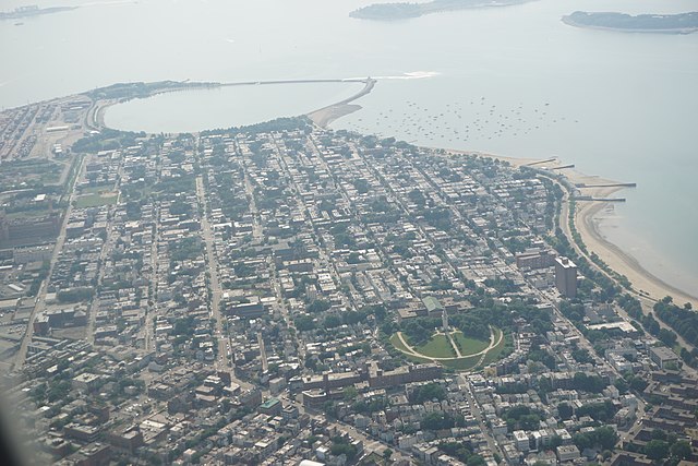
South End, Boston
–
The South End is a neighborhood of Boston, Massachusetts. It is bordered by Back Bay, Chinatown, and Roxbury and it is distinguished from other neighborhoods by its Victorian style houses and the many parks in and around the area. The South End is the largest intact Victorian row house district in the country, eleven residential parks are scattered around the South End. In 1973, the South End was listed in the National Register of Historic Places, the construction of the South End began in 1849 when the neighborhood was built on tidal marshes. It is home to diverse groups, including immigrants, young families, and professionals. Since the 1880s the South End has been characterized by its diversity, with substantial Irish, Lebanese, Jewish, African-American, the South End has five primary and secondary schools that offer education from kindergarten to grade 12. It has a selection of restaurants, bars, art galleries. It is conveniently located within the radius of three libraries which offer many different programs for children and adults, the South End lies south of the Back Bay, northwest of South Boston, northeast of Roxbury, north of Dorchester, and southwest of Bay Village. Despite the name, it is not directly south of the center of downtown Boston, the neighborhood is built upon a former tidal marsh, a part of a larger project of the filling of Bostons Back Bay and South Bay, from the 1830s to the 1870s. Fill was brought in by trains from large trenches of gravel excavated in Needham, the South End was filled and developed before Back Bay, which was mostly built after the American Civil War. Nineteenth-century technology did not allow for driving piles into bedrock. Recent decreases in water levels have caused damage to some wood pilings by exposing them to air. A series of monitoring wells have been drilled and the level is now checked by the Boston Groundwater Trust. The South End was once bordered to the north and west by the Boston and Providence Railroad, the railroad line is now covered by the Southwest Corridor Park and terminates at Back Bay Station. The primary business thoroughfares of the South End are Columbus Avenue, Tremont Street, Washington Street, the original causeway that connected Roxbury to Boston, experienced considerable reinvestment in the 1990s. The street was once defined by the Washington Street Elevated, a train that was moved to below Southwest Corridor Park in the 1980s. Currently, two branches of the Silver Line, Bostons first bus rapid transit line, run along Washington Street, Columbus Avenue, the third main street of the South End, also has numerous restaurants and provides a remarkable straight-line view to the steeple of Park Street Church. Today the modern MBTA Orange Line rapid transit train runs along the partially covered Southwest Corridor, with stops at Back Bay
2.
Neighborhoods in Boston
–
Bostons diverse neighborhoods serve as a political and cultural organizing mechanism. The Boston Redevelopment Authority, the City Parking Clerk, and the Citys Department of Neighborhood Development have also designated their own neighborhoods, unofficially, Boston has many overlapping neighborhoods of various sizes. Neighborhood associations have formed around smaller communities or commercial districts that have a well-defined center, as the city of Boston has grown and evolved, its neighborhoods have changed as well. The names of the West End, North End, and South End refer to their positions on the Shawmut Peninsula, due to the annexation of surrounding communities, those neighborhoods are no longer at those geographic extremities. The Back Bay and Bay Village neighborhoods were part of an actual bay. Brighton, Charlestown, Dorchester, Roxbury, have all at some point been municipalities independent from downtown Boston, Downtown Boston includes Downtown Crossing, the Financial District, and Government Center. Surrounding downtown are the neighborhoods of Chinatown/Leather District, South End, North End, West End, Bay Village, Beacon Hill, Chinatown/Leather District is the historical garment district and today has thriving Chinese and other Asian populations. The South End is the center of the citys LGBT population and also populated by artists, the North End retains an Italian flavor with its many Italian restaurants, though many of its Italian families have moved out, while young professionals have moved in. The Back Bay, west of the Public Garden and Beacon Hill, the Back Bay and Beacon Hill are also home to national and local politicians, famous authors, and top business leaders and professionals. Bay Village is one of the smallest neighborhoods in Boston and mostly contains Greek Revival-style row houses, North and east of downtown are the neighborhoods of East Boston and Charlestown. East Boston has a majority of Hispanic and Brazilian population with a remnant of older Italians, on the north bank of the Charles River is Charlestown, once a predominantly Irish enclave and site of the Bunker Hill Monument, it is now a haven for young professionals. West of downtown are the neighborhoods of Fenway Kenmore, Allston, Brighton and Mission Hill, Fenway Kenmore borders the campus of Boston University and houses many college students and young professionals and is the location of Fenway Park. Allston and Brighton are populated heavily by students from nearby universities, Mission Hill is adjacent to the Longwood Medical district, full of world-class medical institutions and retains an extremely diverse mix of African Americans, Asian Americans, whites and Latinos. South of downtown are the neighborhoods of Roxbury, Jamaica Plain, Dorchester, Mid Dorchester, Dorchester, including Mid Dorchester, is Bostons largest neighborhood and predominantly a working class community considered to be Bostons most diverse. Roxbury is populated largely by African Americans, Caribbean Americans, Jamaica Plain is a community of white professionals and Latinos, and includes the larger side of the Arnold Arboretum. South Boston is a predominantly Irish-American neighborhood, which hosts the citys annual St. Patricks Day parade, South of Roxbury, Jamaica Plain, and Dorchester are the neighborhoods of Mattapan, Roslindale, Hyde Park, and West Roxbury. Roslindale is known for its business district and includes the smaller side of the Arnold Arboretum. Roslindale has also become a majority-minority neighborhood
3.
Geographic coordinate system
–
A geographic coordinate system is a coordinate system used in geography that enables every location on Earth to be specified by a set of numbers, letters or symbols. The coordinates are chosen such that one of the numbers represents a vertical position. A common choice of coordinates is latitude, longitude and elevation, to specify a location on a two-dimensional map requires a map projection. The invention of a coordinate system is generally credited to Eratosthenes of Cyrene. Ptolemy credited him with the adoption of longitude and latitude. Ptolemys 2nd-century Geography used the prime meridian but measured latitude from the equator instead. Mathematical cartography resumed in Europe following Maximus Planudes recovery of Ptolemys text a little before 1300, in 1884, the United States hosted the International Meridian Conference, attended by representatives from twenty-five nations. Twenty-two of them agreed to adopt the longitude of the Royal Observatory in Greenwich, the Dominican Republic voted against the motion, while France and Brazil abstained. France adopted Greenwich Mean Time in place of local determinations by the Paris Observatory in 1911, the latitude of a point on Earths surface is the angle between the equatorial plane and the straight line that passes through that point and through the center of the Earth. Lines joining points of the same latitude trace circles on the surface of Earth called parallels, as they are parallel to the equator, the north pole is 90° N, the south pole is 90° S. The 0° parallel of latitude is designated the equator, the plane of all geographic coordinate systems. The equator divides the globe into Northern and Southern Hemispheres, the longitude of a point on Earths surface is the angle east or west of a reference meridian to another meridian that passes through that point. All meridians are halves of great ellipses, which converge at the north and south poles, the prime meridian determines the proper Eastern and Western Hemispheres, although maps often divide these hemispheres further west in order to keep the Old World on a single side. The antipodal meridian of Greenwich is both 180°W and 180°E, the combination of these two components specifies the position of any location on the surface of Earth, without consideration of altitude or depth. The grid formed by lines of latitude and longitude is known as a graticule, the origin/zero point of this system is located in the Gulf of Guinea about 625 km south of Tema, Ghana. To completely specify a location of a feature on, in, or above Earth. Earth is not a sphere, but a shape approximating a biaxial ellipsoid. It is nearly spherical, but has an equatorial bulge making the radius at the equator about 0. 3% larger than the radius measured through the poles, the shorter axis approximately coincides with the axis of rotation
4.
Massachusetts
–
It is bordered by the Atlantic Ocean to the east, the states of Connecticut and Rhode Island to the south, New Hampshire and Vermont to the north, and New York to the west. The state is named for the Massachusett tribe, which inhabited the area. The capital of Massachusetts and the most populous city in New England is Boston, over 80% of Massachusetts population lives in the Greater Boston metropolitan area, a region influential upon American history, academia, and industry. Originally dependent on agriculture, fishing and trade, Massachusetts was transformed into a manufacturing center during the Industrial Revolution, during the 20th century, Massachusetts economy shifted from manufacturing to services. Modern Massachusetts is a leader in biotechnology, engineering, higher education, finance. Plymouth was the site of the first colony in New England, founded in 1620 by the Pilgrims, in 1692, the town of Salem and surrounding areas experienced one of Americas most infamous cases of mass hysteria, the Salem witch trials. In 1777, General Henry Knox founded the Springfield Armory, which during the Industrial Revolution catalyzed numerous important technological advances, in 1786, Shays Rebellion, a populist revolt led by disaffected American Revolutionary War veterans, influenced the United States Constitutional Convention. In the 18th century, the Protestant First Great Awakening, which swept the Atlantic World, in the late 18th century, Boston became known as the Cradle of Liberty for the agitation there that led to the American Revolution. The entire Commonwealth of Massachusetts has played a commercial and cultural role in the history of the United States. Before the American Civil War, Massachusetts was a center for the abolitionist, temperance, in the late 19th century, the sports of basketball and volleyball were invented in the western Massachusetts cities of Springfield and Holyoke, respectively. Many prominent American political dynasties have hailed from the state, including the Adams, both Harvard University and the Massachusetts Institute of Technology, also in Cambridge, have been ranked among the most highly regarded academic institutions in the world. Massachusetts public school students place among the top nations in the world in academic performance, the official name of the state is the Commonwealth of Massachusetts. While this designation is part of the official name, it has no practical implications. Massachusetts has the position and powers within the United States as other states. Massachusetts was originally inhabited by tribes of the Algonquian language family such as the Wampanoag, Narragansett, Nipmuc, Pocomtuc, Mahican, and Massachusett. While cultivation of crops like squash and corn supplemented their diets, villages consisted of lodges called wigwams as well as longhouses, and tribes were led by male or female elders known as sachems. Between 1617 and 1619, smallpox killed approximately 90% of the Massachusetts Bay Native Americans, the first English settlers in Massachusetts, the Pilgrims, arrived via the Mayflower at Plymouth in 1620, and developed friendly relations with the native Wampanoag people. This was the second successful permanent English colony in the part of North America that later became the United States, the event known as the First Thanksgiving was celebrated by the Pilgrims after their first harvest in the New World which lasted for three days
5.
Suffolk County, Massachusetts
–
Suffolk County is a county in the Commonwealth of Massachusetts, in the United States. As of 2016, the population was 784,230 making it the fourth-most populous county in Massachusetts, the county seat is Boston, the state capital and largest city. Suffolk County is included in the Boston-Cambridge-Newton, MA-NH Metropolitan Statistical Area, the county was created by the Massachusetts General Court on May 10,1643, when it was ordered that the whole plantation within this jurisdiction be divided into four shires. Suffolk initially contained Boston, Roxbury, Dorchester, Dedham, Braintree, Weymouth, the county was named after Suffolk, England, which means southern folk. In 1731, the western portions of Suffolk County, which included Uxbridge, were split off to become part of Worcester County. In 1793, most of the original Suffolk County except for Boston, Chelsea, Hingham, Hingham and Hull would leave Suffolk County and join Plymouth County in 1803. Revere was set off from Chelsea and incorporated in 1846 and Winthrop was set off from Revere, like an increasing number of Massachusetts counties, Suffolk County exists today only as a historical geographic region, and has no county government. All former county functions were assumed by state agencies in 1999, however, communities are now granted the right to form their own regional compacts for sharing services. Politically speaking, Suffolk County supports the Democratic Party overwhelmingly, no Republican presidential candidate has won there since 1924. In 2012 Barack Obama received 77. 4% of the vote, in the 2014 gubernatorial election Martha Coakley carried the county by a 32. 4% margin, while losing the election statewide by 48.4 to 46. 5%. According to the U. S. Census Bureau, the county has an area of 120 square miles. It is the second-smallest county in Massachusetts by land area and smallest by total area, essex County Norfolk County Middlesex County Suffolk County has no land border with Plymouth County to its southeast, but the two counties share a water boundary in the middle of Massachusetts Bay. The population density was 12,415.6 inhabitants per square mile, there were 315,522 housing units at an average density of 5,425.6 per square mile. The racial makeup of the county was 56. 0% white,21. 6% black or African American,8. 2% Asian,0. 4% American Indian,9. 7% from other races, and 3. 9% from two or more races. Those of Hispanic or Latino origin made up 19. 9% of the population, in terms of ancestry,16. 4% were Irish,10. 4% were Italian,5. 2% were English, and 2. 0% were American. The average household size was 2.30 and the family size was 3.11. The median age was 31.5 years, the median income for a household in the county was $50,597 and the median income for a family was $58,127. Males had an income of $48,887 versus $43,658 for females
6.
Boston
–
Boston is the capital and most populous city of the Commonwealth of Massachusetts in the United States. Boston is also the seat of Suffolk County, although the county government was disbanded on July 1,1999. The city proper covers 48 square miles with a population of 667,137 in 2015, making it the largest city in New England. Alternately, as a Combined Statistical Area, this wider commuting region is home to some 8.1 million people, One of the oldest cities in the United States, Boston was founded on the Shawmut Peninsula in 1630 by Puritan settlers from England. It was the scene of several key events of the American Revolution, such as the Boston Massacre, the Boston Tea Party, the Battle of Bunker Hill, and the Siege of Boston. Upon U. S. independence from Great Britain, it continued to be an important port and manufacturing hub as well as a center for education, through land reclamation and municipal annexation, Boston has expanded beyond the original peninsula. Its rich history attracts many tourists, with Faneuil Hall alone drawing over 20 million visitors per year, Bostons many firsts include the United States first public school, Boston Latin School, first subway system, the Tremont Street Subway, and first public park, Boston Common. Bostons economic base also includes finance, professional and business services, biotechnology, information technology, the city has one of the highest costs of living in the United States as it has undergone gentrification, though it remains high on world livability rankings. Bostons early European settlers had first called the area Trimountaine but later renamed it Boston after Boston, Lincolnshire, England, the renaming on September 7,1630 was by Puritan colonists from England who had moved over from Charlestown earlier that year in quest of fresh water. Their settlement was limited to the Shawmut Peninsula, at that time surrounded by the Massachusetts Bay and Charles River. The peninsula is thought to have been inhabited as early as 5000 BC, in 1629, the Massachusetts Bay Colonys first governor John Winthrop led the signing of the Cambridge Agreement, a key founding document of the city. Puritan ethics and their focus on education influenced its early history, over the next 130 years, the city participated in four French and Indian Wars, until the British defeated the French and their Indian allies in North America. Boston was the largest town in British America until Philadelphia grew larger in the mid-18th century, Bostons harbor activity was significantly curtailed by the Embargo Act of 1807 and the War of 1812. Foreign trade returned after these hostilities, but Bostons merchants had found alternatives for their investments in the interim. Manufacturing became an important component of the economy, and the citys industrial manufacturing overtook international trade in economic importance by the mid-19th century. Boston remained one of the nations largest manufacturing centers until the early 20th century, a network of small rivers bordering the city and connecting it to the surrounding region facilitated shipment of goods and led to a proliferation of mills and factories. Later, a network of railroads furthered the regions industry. Boston was a port of the Atlantic triangular slave trade in the New England colonies
7.
Eastern Time Zone
–
Places that use Eastern Standard Time when observing standard time are 5 hours behind Coordinated Universal Time. Eastern Daylight Time, when observing daylight saving time DST is 4 hours behind Coordinated Universal Time, in the northern parts of the time zone, on the second Sunday in March, at 2,00 a. m. EST, clocks are advanced to 3,00 a. m. EDT leaving a one-hour gap, on the first Sunday in November, at 2,00 a. m. EDT, clocks are moved back to 1,00 a. m, southern parts of the zone do not observe daylight saving time. The Uniform Time Act of 1966 ruled that daylight saving time would run from the last Sunday of April until the last Sunday in October in the United States, the act was amended to make the first Sunday in April the beginning of daylight saving time as of 1987. The Energy Policy Act of 2005 extended daylight saving time in the United States beginning in 2007. So local times change at 2,00 a. m. EST to 3,00 a. m. EDT on the second Sunday in March, in Canada, the time changes as it does in the United States. However, a handful of communities unofficially observe Eastern Time because they are part of the Columbus, Georgia metropolitan area – Phenix City, Smiths Station, Lanett, and Valley. Florida, All of Florida is in the Eastern Time zone except for the portion of the Florida Panhandle west of the Apalachicola River, as the Eastern–Central zone boundary approaches the Gulf of Mexico, it follows the Bay/Gulf county line. Indiana, All of Indiana observes Eastern Time except for six counties in the Chicago metropolitan area. Kentucky, Roughly, the half of the state, including all of metropolitan Louisville, is in the Eastern Time Zone. Historically the entire state observed Central Time, when daylight saving time was first introduced, the Lower Peninsula remained on DST after it formally ended, effectively re-aligning itself into the Eastern Time Zone. The Upper Peninsula continued to observe Central Time until 1972, when all, Tennessee, Most of the eastern third of Tennessee is legally on Eastern Time. Eastern Time is also used somewhat as a de facto official time for all of the United States, since it includes the capital and the largest city. Major professional sports leagues also post all game times in Eastern time, for example, a game time between two teams from Pacific Time Zone will still be posted in Eastern time. Most cable television and national broadcast networks advertise airing times in Eastern time, national broadcast networks generally have two primary feeds, an eastern feed for Eastern and Central time zones, and a tape-delayed western feed for the Pacific Time Zone. The prime time is set on Eastern and Pacific at 8,00 p. m. with the Central time zone stations receiving the eastern feed at 7,00 p. m. local time. Mountain Time Zone stations receive a separate feed at 7,00 p. m. local time, as Arizona does not observe daylight saving time, during the summer months, it has its own feed at 7,00 p. m. local time
8.
UTC-5
–
UTC−05,00 is a time offset that subtracts five hours from Coordinated Universal Time. In North America, it is observed in the Eastern Time Zone during standard time, the western Caribbean uses it year round. The southwestern and northwestern portions of Indiana Mexico – Central Zone Central, in most of Mexico, daylight time starts a few weeks after the United States. Communities on the U. S. border that observe Central Time follow the U. S. daylight time schedule
9.
Area codes 617 and 857
–
Area codes 617 and 857 are the North American area codes serving Boston and several surrounding communities in Massachusetts—such as Brookline, Cambridge, Newton and Quincy. In July 1988, most of the western and southern portions of the old 617 territory, including Worcester, the South Coast and it was split again in 1997, when most of Bostons outer suburbs split off as 781. This reduced 617 to Boston itself and its closer-in suburbs—an area largely coextensive with the ring of Greater Boston. This was intended as a solution, but within three years 617 was close to exhaustion once again due to the demand for more phone lines for auxiliary devices. The supply of numbers was limited because the entire eastern half of Massachusetts is still a single LATA. On May 2,2001,857 was overlaid onto 617, since then,10 digit local dialing is mandatory. Some mobile phone numbers from the 1990s assigned to communities in the area surrounding 617 kept the 617 area code just on those mobile lines after it split
10.
Fort Point Channel
–
Fort Point Channel is a maritime channel separating South Boston from downtown Boston, Massachusetts, feeding into Boston Harbor. The south part of it has gradually filled in for use by the South Bay rail yard. At its south end, the channel once widened into South Bay, the Boston Tea Party occurred at its northern end. The channel is surrounded by the Fort Point neighborhood, which is named after the same colonial-era fort. The banks of the channel are still busy with activity, South of Summer Street on the west side of the channel is a large United States Postal Service facility. A large parcel, home to Gillette, lies at the southeast corner of the channel. The back of the Federal Reserve Bank of Boston looks over the channel, and another federal building, one of Bostons odder attractions, the Hood Milk Bottle, lies on the banks as well, next to Boston Childrens Museum. During the 1980s, a nightclub and popular concert venue called The Channel was located on the South Boston bank, on October 21,2011, Fort Point Pier opened for public use south of the Summer Street Bridge. To prepare for construction, a section of the Fort Point Channel seawall south of Necco Court was restored by P&G Gillette. Public access has made Fort Point Channel popular for kayaking and standup paddle boarding
11.
Working class
–
The working class are the people employed for wages, especially in manual-labour occupations and in skilled, industrial work. Working-class occupations include blue-collar jobs, some jobs, and most service-work jobs. As with many terms describing social class, working class is defined and used in different ways. The most general definition, used by Marxists and socialists, is that the class includes all those who have nothing to sell but their labor-power. When used non-academically in the United States, however, it refers to a section of society dependent on physical labor. For certain types of science, as well as scientific or journalistic political analysis, for example. Working-class occupations are then categorized into four groups, Unskilled laborers, artisans, outworkers, a common alternative, sometimes used in sociology, is to define class by income levels. The cut-off between working class and middle class here might mean the line where a population has discretionary income, some researchers have suggested that working-class status should be defined subjectively as self-identification with the working-class group. This subjective approach allows people, rather than researchers, to define their own social class, in feudal Europe, the working class as such did not exist in large numbers. Instead, most people were part of the class, a group made up of different professions, trades. A lawyer, craftsman and peasant were all considered to be part of the social unit. Similar hierarchies existed outside Europe in other pre-industrial societies, the social position of these laboring classes was viewed as ordained by natural law and common religious belief. This social position was contested, particularly by peasants, for example during the German Peasants War, wealthy members of these societies created ideologies which blamed many of the problems of working-class people on their morals and ethics. In The Making of the English Working Class, E. P, starting around 1917, a number of countries became ruled ostensibly in the interests of the working class. Since then, four major states have turned towards semi-market-based governance. Other states of this sort have either collapsed, or never achieved significant levels of industrialization or large working classes, since 1960, large-scale proletarianisation and enclosure of commons has occurred in the third world, generating new working classes. Additionally, countries such as India have been slowly undergoing social change, karl Marx defined the working class or proletariat as individuals who sell their labour power for wages and who do not own the means of production. He argued that they were responsible for creating the wealth of a society and he asserted that the working class physically build bridges, craft furniture, grow food, and nurse children, but do not own land, or factories
12.
Dorchester Heights
–
Dorchester Heights is the central area of South Boston. It is the highest area in the neighborhood and commands a view of both Boston Harbor and downtown, Dorchester is remembered in American history for an action in the American Revolutionary War known as the Fortification of Dorchester Heights. In June 1775 British soldiers under General William Howe attacked and seized Bunker Hill, following this encounter, the Continental Congress in Philadelphia gave George Washington the title of commander-in-chief and sent him to oversee the Siege of Boston. This added artillery gave Washington the firepower needed to make a decisive move, on the night of March 4,1776, as 800 American soldiers stood guard along the river of Dorchester shores,1,200 American soldiers occupied Dorchester Heights. They began working through the night to build structures suitable to defend against the British Army, in response, Howe planned a counteroffensive to take the fortified positions on the Heights, but bad weather forced him to reconsider. The Royal Navy evacuated the British Army from Boston on March 17,1776, March 17 is observed as the holiday Evacuation Day in Suffolk County, Massachusetts. Dorchester Heights is a hilltop, and affords views of many communities to the south. The Dorchester Heights monument area was listed on the National Register in 1966. An area near the top of Telegraph Hill was used as the site of a reservoir to provide water to South Boston in 1849 and this reservoir was later filled in and South Boston High School was built on the site in 1901. The rest of the summit of the hill was developed as Thomas Park in the 1850s, during restoration work in the 1990s, archaeologists uncovered evidence of the Revolutionary War fortifications, previously thought to have been destroyed by the parks construction. The Dorchester Heights Monument, located at the center of Thomas Park, was completed in 1902 to designs by Boston architects Peabody and Stearns. It is 115 feet tall, built of Georgia white marble capped with octagonal cupola and weather vane, the monument is now operated by the National Park Service as part of Boston National Historical Park. National Register of Historic Places listings in southern Boston, Massachusetts Notes Sources National Park Service, Dorchester Heights Sammarco, Anthony Mitchell, Rosenberg, then & now, Images of America, a history of American life in images and texts
13.
George Washington
–
George Washington was an American politician and soldier who served as the first President of the United States from 1789 to 1797 and was one of the Founding Fathers of the United States. He served as Commander-in-Chief of the Continental Army during the American Revolutionary War and he is popularly considered the driving force behind the nations establishment and came to be known as the father of the country, both during his lifetime and to this day. Washington was widely admired for his leadership qualities and was unanimously elected president by the Electoral College in the first two national elections. Washingtons incumbency established many precedents still in use today, such as the system, the inaugural address. His retirement from office two terms established a tradition that lasted until 1940 when Franklin Delano Roosevelt won an unprecedented third term. The 22nd Amendment now limits the president to two elected terms and he was born into the provincial gentry of Colonial Virginia to a family of wealthy planters who owned tobacco plantations and slaves, which he inherited. In his youth, he became an officer in the colonial militia during the first stages of the French. In 1775, the Second Continental Congress commissioned him as commander-in-chief of the Continental Army in the American Revolution, in that command, Washington forced the British out of Boston in 1776 but was defeated and nearly captured later that year when he lost New York City. After crossing the Delaware River in the middle of winter, he defeated the British in two battles, retook New Jersey, and restored momentum to the Patriot cause and his strategy enabled Continental forces to capture two major British armies at Saratoga in 1777 and Yorktown in 1781. In battle, however, Washington was repeatedly outmaneuvered by British generals with larger armies, after victory had been finalized in 1783, Washington resigned as commander-in-chief rather than seize power, proving his opposition to dictatorship and his commitment to American republicanism. Washington presided over the Constitutional Convention in 1787, which devised a new form of government for the United States. Following his election as president in 1789, he worked to unify rival factions in the fledgling nation and he supported Alexander Hamiltons programs to satisfy all debts, federal and state, established a permanent seat of government, implemented an effective tax system, and created a national bank. In avoiding war with Great Britain, he guaranteed a decade of peace and profitable trade by securing the Jay Treaty in 1795 and he remained non-partisan, never joining the Federalist Party, although he largely supported its policies. Washingtons Farewell Address was a primer on civic virtue, warning against partisanship, sectionalism. He retired from the presidency in 1797, returning to his home, upon his death, Washington was eulogized as first in war, first in peace, and first in the hearts of his countrymen by Representative Henry Lee III of Virginia. He was revered in life and in death, scholarly and public polling consistently ranks him among the top three presidents in American history and he has been depicted and remembered in monuments, public works, currency, and other dedications to the present day. He was born on February 11,1731, according to the Julian calendar, the Gregorian calendar was adopted within the British Empire in 1752, and it renders a birth date of February 22,1732. Washington was of primarily English gentry descent, especially from Sulgrave and his great-grandfather John Washington emigrated to Virginia in 1656 and began accumulating land and slaves, as did his son Lawrence and his grandson, Georges father Augustine
14.
American Revolutionary War
–
From about 1765 the American Revolution had led to increasing philosophical and political differences between Great Britain and its American colonies. The war represented a culmination of these differences in armed conflict between Patriots and the authority which they increasingly resisted. This resistance became particularly widespread in the New England Colonies, especially in the Province of Massachusetts Bay. On December 16,1773, Massachusetts members of the Patriot group Sons of Liberty destroyed a shipment of tea in Boston Harbor in an event that became known as the Boston Tea Party. Named the Coercive Acts by Parliament, these became known as the Intolerable Acts in America. The Massachusetts colonists responded with the Suffolk Resolves, establishing a government that removed control of the province from the Crown outside of Boston. Twelve colonies formed a Continental Congress to coordinate their resistance, and established committees, British attempts to seize the munitions of Massachusetts colonists in April 1775 led to the first open combat between Crown forces and Massachusetts militia, the Battles of Lexington and Concord. Militia forces proceeded to besiege the British forces in Boston, forcing them to evacuate the city in March 1776, the Continental Congress appointed George Washington to take command of the militia. Concurrent to the Boston campaign, an American attempt to invade Quebec, on July 2,1776, the Continental Congress formally voted for independence, issuing its Declaration on July 4. Sir William Howe began a British counterattack, focussing on recapturing New York City, Howe outmaneuvered and defeated Washington, leaving American confidence at a low ebb. Washington captured a Hessian force at Trenton and drove the British out of New Jersey, in 1777 the British sent a new army under John Burgoyne to move south from Canada and to isolate the New England colonies. However, instead of assisting Burgoyne, Howe took his army on a campaign against the revolutionary capital of Philadelphia. Burgoyne outran his supplies, was surrounded and surrendered at Saratoga in October 1777, the British defeat in the Saratoga Campaign had drastic consequences. Giving up on the North, the British decided to salvage their former colonies in the South, British forces under Lieutenant-General Charles Cornwallis seized Georgia and South Carolina, capturing an American army at Charleston, South Carolina. British strategy depended upon an uprising of large numbers of armed Loyalists, in 1779 Spain joined the war as an ally of France under the Pacte de Famille, intending to capture Gibraltar and British colonies in the Caribbean. Britain declared war on the Dutch Republic in December 1780, in 1781, after the British and their allies had suffered two decisive defeats at Kings Mountain and Cowpens, Cornwallis retreated to Virginia, intending on evacuation. A decisive French naval victory in September deprived the British of an escape route, a joint Franco-American army led by Count Rochambeau and Washington, laid siege to the British forces at Yorktown. With no sign of relief and the situation untenable, Cornwallis surrendered in October 1781, Whigs in Britain had long opposed the pro-war Tory majority in Parliament, but the defeat at Yorktown gave the Whigs the upper hand
15.
Gentrification
–
Gentrification is a process of renovation of deteriorated urban neighborhoods by means of the influx of more affluent residents. This is a common and controversial topic in politics and in urban planning, conversations surrounding gentrification have evolved, as many in the social-scientific community have questioned the negative connotations associated with the word gentrification. Gentrification is typically the result of increased interest in a certain environment, early gentrifiers may belong to low-income artist or boheme communities, which increase the attractiveness and flair of a certain quarter. In addition to these benefits, gentrification can lead to population migration. The term gentrification has come to refer to a phenomenon that can be defined in different ways. Historians say that gentrification took place in ancient Rome and in Roman Britain, the word gentrification derives from gentry—which comes from the Old French word genterise, of gentle birth and people of gentle birth. In England, Landed gentry denoted the social class, consisting of gentlemen and this change has the potential to cause displacement of long-time residents and businesses. When long-time or original neighborhood residents move from an area because of higher rents, mortgages. Gentrification is a housing, economic, and health issue that affects a communitys history and culture and it often shifts a neighborhoods characteristics, e. g. racial-ethnic composition and household income, by adding new stores and resources in previously run-down neighborhoods. German geographers have a more distanced view on gentrification, actual gentrification is seen as a mere symbolic issue happening in a low amount of places and blocks, the symbolic value and visibility in public discourse being higher than actual migration trends. Gerhard Hard assumes that urban flight is more important than inner city gentrification. Volkskunde scholar Barbara Lang introduced the term symbolic gentrification with regard to the Mythos Kreuzberg in Berlin, Lang assumes that complaints about gentrification often come from those who have been responsible for the process in their youth. When former students and bohemians started raising families and earning money in better paid jobs, especially Berlin is a showcase of intense debates about symbols of gentrification, while the actual processes are much slower than in other cities. The citys Prenzlauer Berg district is, however, a child of the capitals gentrification. This leads to mixed feelings amidst the local population, the neologism Bionade-Biedermeier was coined about Prenzlauer Berg. It describes the milieu of the former quartier of the alternative scene. There are several approaches that attempt to explain the roots and the reasons behind the spread of gentrification, bruce London and J. John Palen compiled a list of five explanations, demographic-ecological, sociocultural, political-economical, community networks, and social movements. The first theory, demographic-ecological, attempts to explain gentrification through the analysis of demographics, population, social organization, environment and this theory frequently refers to the growing number of people between the ages of 25 and 35 in the 1970s, or the baby boom generation
16.
Boston busing desegregation
–
The desegregation of Boston public schools was a period in which the Boston Public Schools were under court control to desegregate through a system of busing students. The call for desegregation and the first years of its implementation led to a series of protests and riots that brought national attention. The hard control of the desegregation plan lasted for over a decade and it influenced Boston politics and contributed to demographic shifts of Bostons school-age population, leading to a decline of public-school enrollment and white flight to the suburbs. Full control of the plan was transferred to the Boston School Committee in 1988. The Racial Imbalance Act of 1965 is a piece of legislation passed by the Massachusetts General Court which made the segregation of public schools illegal in Massachusetts and these racially imbalanced schools were to desegregate according to the law or risk losing their state educational funding. An initial report released in March 1965, Because it is Right-Educationally, in 1972, the NAACP filed a class-action lawsuit against the Boston School Committee on behalf of 14 parents and 44 children alleging segregation in the Boston public schools. As a remedy, Garrity used a plan developed by the Massachusetts State Board of Education. In one part of the plan, Judge Garrity decided that the junior class from the mostly poor white South Boston High School would be bused to Roxbury High School. Half the sophomores from each school would attend the other, david Frum asserts that South Boston and Roxbury were generally regarded as the two worst schools in Boston, and it was never clear what educational purpose was to be served by jumbling them. For three years after the plan commenced, Massachusetts state troopers were stationed at South Boston High, the first day of the plan, only 100 of 1,300 students came to school at South Boston. Only 13 of the 550 South Boston juniors ordered to attend Roxbury showed up, parents showed up every day to protest, and football season was cancelled. Whites and blacks began entering through different doors, an anti-busing mass movement developed, called Restore Our Alienated Rights. The final Judge Garrity-issued decision in Morgan v. Hennigan came in 1985, the integration plan aroused fierce criticism among some Boston residents. Of the 100,000 enrolled in Boston school districts, attendance fell from 60,000 to 40,000 during these years, opponents personally attacked Judge Garrity, claiming that because he lived in a white suburb, his own children were not affected by his ruling. The co-author of the plan, Robert Dentler, lived in the suburb of Lexington. Senator Ted Kennedy was also criticized for supporting busing when he sent his own children to private schools, Restore Our Alienated Rights was an anti-desegregation busing organization formed in Boston, Massachusetts by Boston School Committee chairwoman Louise Day Hicks in 1974. By 1976, with the failure to block implementation of the busing plan, there were a number of protest incidents that turned severely violent, even resulting in deaths. In one case, attorney Theodore Landsmark was attacked and bloodied by a group of teenagers as he exited Boston City Hall
17.
Evacuation Day (Massachusetts)
–
Evacuation Day is a holiday observed on March 17 in Suffolk County, Massachusetts and also by the public schools in Somerville, Massachusetts. The holiday commemorates the evacuation of British forces from the city of Boston following the Siege of Boston, schools and government offices are closed. If March 17 falls on a weekend, schools and government offices are closed on the following Monday in observance and it is the same day as Saint Patricks Day, a coincidence that played a role in the establishment of the holiday. The 11-month siege of Boston ended when the Continental Army, under the command of George Washington, British General William Howe, whose garrison and navy were threatened by these positions, was forced to decide between attack and retreat. To prevent what could have been a repeat of the Battle of Bunker Hill, Howe decided to retreat, the British evacuation was Washingtons first victory of the war. It was also a huge morale boost for the Thirteen Colonies, the state made it a holiday in Suffolk County in 1938. The large Irish population of Boston at that time played a role in the establishment of the holiday, a 1941 law establishing the holiday in Suffolk County was signed in both black and green ink. Evacuation Day activities in the areas that observe the holiday are limited, most events of note, like the annual parade and politicians breakfast in South Boston, are dominated by celebrations of Irish culture. The parade is designated the Saint Patricks Day and Evacuation Day Parade. The Allied War Veterans of South Boston mark the day with a ceremony on Dorchester Heights, mayor Thomas Menino boycotted the parade every year he was in office, in protest of the exclusion of GLB marchers. Another local holiday observing an event in the American Revolutionary War is Bunker Hill Day, state workers outside Suffolk County are allowed to choose any two days off in lieu of celebrating Evacuation Day and Bunker Hill Day on the observance days. The two holidays are not observed by the private businesses. In Charlestown, where the Battle of Bunker Hill took place, some government services remain in operation, such as trash pickup in the City of Boston and all state Registry of Motor Vehicle offices. The MBTA runs a schedule but, due to special events, prohibits bicycles on the subway. In 2010, the legislature debated eliminating Evacuation Day and Bunker Hill Day as official holidays, citing the expense of giving state. The states FY2011 budget requires all state and municipal offices in Suffolk County be open on both days, patriots Day Massacre Day Evacuation Day OConnor, Thomas H. South Boston, My Home Town, The History of an Ethnic Neighborhood, when in Boston, a time line & almanac. Archived from the original on March 18,2009
18.
History of Boston
–
The history of Boston plays a central role in American history. In 1630, Puritan colonists from England founded Boston and helped it become the way it is today, Boston quickly became the political, commercial, financial, religious and educational center of the New England region. The American Revolution erupted in Boston, as the British retaliated harshly for the Boston Tea Party and the patriots fought back. They besieged the British in the city, with a battle at Bunker Hill in Charlestown on June 17,1775 and won the Siege of Boston. However, the combination of American and British blockades of the town and port during the conflict seriously damaged the economy, along with New York, Boston was the financial center of the United States in the 19th century, and was especially important in funding railroads nationwide. In the Civil War era, it was the base for many anti-slavery activities, in the 19th century the city was dominated by an elite known as the Boston Brahmins. They faced the political challenge coming from Catholic immigrants, the Irish Catholics, typified by the Kennedy Family, took political control of the city by 1900. The industrial foundation of the region, financed by Boston, reached its peak around 1950, thereafter thousands of textile mills and other factories were closed down and the city went into decline. By the 21st century the economy had recovered and was centered on education, medicine. The Shawmut Peninsula was originally connected to the mainland to its south by an isthmus, Boston Neck, and surrounded by Boston Harbor and the Back Bay. In 1628, the Cambridge Agreement was signed in England among the Puritans of the Massachusetts Bay Colony, the agreement established the colony as a self-governing entity, answerable only to the king. John Winthrop was its leader, and would become governor of the settlement in the New World, in a famous sermon, A Model of Christian Charity, Winthrop described the new colony as a City upon a Hill. The competing Plymouth Colony had been founded in 1620, it would merge with the Massachusetts Bay Colony in 1691. In June 1630, the Winthrop Fleet arrived in what would later be called Salem and they proceeded to Charlestown, which pleased them less, for lack of fresh water. The Puritans settled around the spring in what would become Boston, acquiring the land from the first English settler, trimountaine was the name given by the 1630 settlers to the peninsula that would later be incorporated as the City of Boston. The name was derived from a set of three prominent hills on the peninsula, two of which were leveled as the city was modernized, the middle one, Beacon Hill, shortened between 1807 and 1824, remains to this day as a prominent feature of the Boston cityscape. Tremont Street still carries an alternate form of the original name, the two smaller peaks were Cotton Hill and Mt. Whoredom. The name also derives from Saint Botolph, who was the saint of travelers
19.
Dorchester, Boston
–
Dorchester is a historic neighborhood comprising over 6 square miles in Boston, Massachusetts, United States. Originally, Dorchester was a town, founded by Puritans who emigrated in 1630 from Dorchester, Dorset. Founded in 1630, just a few months before the founding of the city of Boston and it was still a primarily rural town and had a population of 12,000 when it was annexed to Boston in 1870. Railroad and streetcar lines brought rapid growth, increasing the population to 150,000 by 1920, in the 2010 United States Census, the population was 92,115. Dorchester as a municipality would rank among the top five Massachusetts cities. Most of the people over the age of 25 have completed high school or obtained a GED, nearly 60% of the population earns less than $40,000 per year and a majority of them live in rental units. Currently, there is a crisis occurring and, as a result. The original settlement founded in 1630 was at what is now the intersection of Columbia Road and Massachusetts Avenue. Most of the early Dorchester settlers came from the West Country of England, and some from Dorchester, Dorset, on October 8,1633, the first Town Meeting in America was held in Dorchester. Today, each October 8 is celebrated as Town Meeting Day in Massachusetts, Dorchester is the birthplace of the first public elementary school in America, the Mather School, established in 1639. The school still stands as the oldest elementary school in America, the Blake House was constructed in 1661, as was confirmed by dendrochronology in 2007. In 1695, a party was dispatched to found the town of Dorchester, South Carolina and they soon after opened Americas first chocolate mill and factory in the Lower Mills section of Dorchester. The Walter Baker Chocolate Factory, part of Walter Baker & Company, before the American Revolution, The Sons of Liberty met in August 1769 at the Lemuel Robinson Tavern, which stood on the east side of the upper road near the present Fuller Street. Lemuel Robinson was a representative of the town during the Revolution and was appointed a colonel in the Revolutionary army, Dorchester was also the site of the Battle of Dorchester Heights in 1776, which eventually resulted in the British evacuating Boston. In Victorian times, Dorchester became a country retreat for Boston elite. The mother and grandparents of John F. Kennedy lived in the Ashmont Hill neighborhood while John F, honey Fitz Fitzgerald was mayor of Boston. In 1845, the Old Colony Railroad ran through the area and connected Boston and Plymouth, the station was originally called Crescent Avenue or Crescent Avenue Depot as an Old Colony Railroad station, then called Columbia until December 1,1982, and then again changed to JFK/UMASS. It is a Massachusetts Bay Transportation Authority rail line station for both the Red subway and the Plymouth/Kingston, Middleborough/Lakeville and Greenbush commuter rail lines
20.
Fort William and Mary
–
Fort William and Mary was a colonial fortification in Britains worldwide system of defenses, manned by soldiers of the Province of New Hampshire who reported directly to the royal governor. The fort, originally known as The Castle, was situated on the island of New Castle, New Hampshire and it was renamed Fort William and Mary circa 1692, after the accession of the monarchs to the British throne. It was captured by Patriot forces, recaptured, and later abandoned by the British in the Revolutionary War, the fort was renamed Fort Constitution in 1808 following rebuilding. The fort was rebuilt and expanded through 1899 and served actively through World War II. First fortified by the British prior to 1632, the fort guarded access to the harbor at Portsmouth and served as the colonys main munitions depot. The fort also served to protect Kittery, Maine, on the opposite shore, shadrach Walton commanded the fort during different periods at the end of the 17th and beginning of the 18th century. In 1774, it was the only permanently manned military post in New Hampshire, on December 15,1774, patriots led by John Sullivan again raided the fort, this time seizing numerous cannons. As tensions increased before the American Revolutionary War, Lord Norths ministry became concerned that the profusion of arms in New England would lead to bloodshed, on October 19,1774, King George III issued a confidential Order in Council forbidding the export of arms and powder to America. Word of the order reached operatives in New Englands patriot movement, the port at Boston had been closed in punishment for the Boston Tea Party, and the Portsmouth Committee of Correspondence kept in close contact with friends of liberty in Boston. Tensions in Massachusetts nearly erupted into violence in the fall of 1774 when redcoats seized provincial gunpowder during the so-called Powder Alarm, upon learning of the Order in Council, patriots feared that the British military would make another attempt to seize colonial stores. Patriots in Rhode Island moved munitions from the fort at Newport inland for safekeeping without incident, in Massachusetts, rumors flew that troops from Boston were headed to reinforce Fort William and Mary and seize its powder and arms. On December 13,1774, four months before his famous ride in Massachusetts. On the morning of December 14, Patriots from the town of New Castle unsuccessfully attempted to take the gunpowder at Fort William, meanwhile, John Langdon made his way through Portsmouth with a drummer, collecting a crowd to descend on the fort. Several hundred men responded to his call, setting out for the Castle by way of the Piscataqua River, only one provincial officer, Captain John Cochran, and five provincial soldiers were stationed at Fort William and Mary. Despite the odds against them, they refused to capitulate to Patriot demands, when Langdons men rushed the fort, the defenders opened fire with three cannons and a volley of musket shot. Patriots stormed the walls and Cochrans men engaged in hand-to-hand fighting before being subdued by a number of raiders. Langdons volunteers not only open the powder house and absconded with about 100 barrels of gunpowder but. Several injuries but no deaths occurred in the engagement, and Cochran and his men were released after about an hour, the next day, additional rebel forces arrived in Portsmouth from across the colony, as well as from Maine
21.
Halifax, Nova Scotia
–
Halifax, legally known as the Halifax Regional Municipality, is the capital of the province of Nova Scotia, Canada. The municipality had a population of 403,131 in 2016, the regional municipality consists of four former municipalities that were amalgamated in 1996, Halifax, Dartmouth, Bedford, and the Municipality of Halifax County. Halifax is an economic centre in Atlantic Canada with a large concentration of government services. Agriculture, fishing, mining, forestry and natural gas extraction are major resource found in the rural areas of the municipality. Additionally, Halifax has consistently placed in the top 10 for business friendliness of North and South American cities, the first permanent European settlement in the region was on the Halifax Peninsula. The establishment of the Town of Halifax, named after the 2nd Earl of Halifax, the establishment of Halifax marked the beginning of Father Le Loutres War. The war began when Edward Cornwallis arrived to establish Halifax with 13 transports, by unilaterally establishing Halifax the British were violating earlier treaties with the Mikmaq, which were signed after Father Rales War. Cornwallis brought along 1,176 settlers and their families, St. Margarets Bay was first settled by French-speaking Foreign Protestants at French Village, Nova Scotia who migrated from Lunenburg, Nova Scotia during the American Revolution. The resulting explosion, the Halifax Explosion, devastated the Richmond District of Halifax, killing approximately 2,000 people, the blast was the largest artificial explosion before the development of nuclear weapons. Significant aid came from Boston, strengthening the bond between the two coastal cities, the municipal boundary thus now includes all of Halifax County except for several First Nation reserves. Since amalgamation, the region has officially been known as the Halifax Regional Municipality, on April 15,2014, the regional council approved the implementation of a new branding campaign for the region developed by the local firm Revolve Marketing. The campaign would see the region referred to in promotional materials simply as Halifax, mayor Mike Savage defended the decision, stating, Im a Westphal guy, Im a Dartmouth man, but Halifax is my city, we’re all part of Halifax. Because when I go and travel on behalf of this municipality, metropolitan Halifax is a term used to describe the urban concentration surrounding Halifax Harbour, including the Halifax Peninsula, the core of Dartmouth, and the Bedford-Sackville areas. It is the Statistics Canada population centre of Halifax, the dense urban core is centred on the Halifax Peninsula and the area of Dartmouth inside of the Circumferential Highway. The suburban area stretches into areas known as Mainland Halifax to the west, Cole Harbour to the east and this urban area is the most populous on Canadas Atlantic coast, and the second largest coastal population centre in the country after Vancouver, British Columbia. Halifax currently accounts for 40% of Nova Scotias population, and 15% of that of Atlantic Canada, Halifaxs urban core is home to a number of regional landmark buildings and retains significant historic buildings and districts. The downtowns office towers are overlooked by the fortress of Citadel Hill with its iconic Halifax Town Clock, Dalhousie Universitys campus is often featured in films and documentaries. Dartmouth also has its share of historic neighbourhoods and this has resulted in some modern high rises being built at unusual angles or locations
22.
Nova Scotia
–
Nova Scotia is one of Canadas three Maritime provinces, and one of the four provinces which form Atlantic Canada. Nova Scotia is Canadas second-smallest province, with an area of 55,284 square kilometres, including Cape Breton, as of 2016, the population was 923,598. Nova Scotia is the second most-densely populated province in Canada with 17.4 inhabitants per square kilometre, Nova Scotia means New Scotland in Latin and is the recognized English language name for the province. In Scottish Gaelic, the province is called Alba Nuadh, which simply means New Scotland. Nova Scotia is Canadas second-smallest province in area after Prince Edward Island, the provinces mainland is the Nova Scotia peninsula surrounded by the Atlantic Ocean, including numerous bays and estuaries. Nowhere in Nova Scotia is more than 67 km from the ocean, Nova Scotia has many ancient fossil-bearing rock formations. These formations are rich on the Bay of Fundys shores. Blue Beach near Hantsport, Joggins Fossil Cliffs, on the Bay of Fundys shores, has yielded an abundance of Carboniferous age fossils, wassons Bluff, near the town of Parrsboro, has yielded both Triassic and Jurassic age fossils. Nova Scotia lies in the mid-temperate zone, since the province is almost surrounded by the sea, the climate is closer to maritime than to continental climate. The winter and summer temperature extremes of the climate are moderated by the ocean. However, winters are cold enough to be classified as continental – still being nearer the freezing point than inland areas to the west. The Nova Scotia climate is in ways similar to the central Baltic Sea coast in Northern Europe. This is in spite of Nova Scotia being some fifteen parallels south, areas not on the Atlantic coast experience warmer summers more typical of inland areas, and winter lows a little colder. The province includes regions of the Mikmaq nation of Mikmaki, the Mikmaq people inhabited Nova Scotia at the time the first European colonists arrived. In 1605, French colonists established the first permanent European settlement in the future Canada at Port Royal, the British conquest of Acadia took place in 1710. The Treaty of Utrecht in 1713 formally recognized this and returned Cape Breton Island to the French, present-day New Brunswick then still formed a part of the French colony of Acadia. The British changed the name of the capital from Port Royal to Annapolis Royal, in 1749, the capital of Nova Scotia moved from Annapolis Royal to the newly established Halifax. In 1755 the vast majority of the French population were removed in the Expulsion of the Acadians
23.
Fort Independence (Massachusetts)
–
Fort Independence is a granite bastion fort that provided harbor defenses for Boston, Massachusetts. Located on Castle Island, Fort Independence is one of the oldest continuously fortified sites of English origin in the United States. The first primitive fortification, called The Castle, was placed on the site in 1634 and, re-built after it was abandoned by the British during the American Revolution, Castle William was renamed Fort Adams and then Fort Independence. The existing granite fort was constructed between 1833 and 1851, today it is preserved as a state park and fires occasional ceremonial salutes. Fort Independence was added to the National Register of Historic Places in 1970, the site of Fort Independence has been occupied by various fortifications since 1634. The first fort to be constructed on Castle Island resulted from a visit by Governor John Winthrop, it was financed by him. Construction was planned and supervised by Deputy Gov, the first commander of the fort was Captain Nicholas Simpkins in 1634. The first fort soon fell into disrepair and was rebuilt, mainly out of timber, the fort was reconstructed out of pine logs, stone, and earth, with 10-foot walls around a compound 50 feet square. The fort mounted six saker cannons and three smaller guns, a later commander of the fort was Captain Richard Davenport, who supervised the post from 1645 until 1665 when he was struck by lightning within the fort and killed. His successor, Captain Roger Clap, commanded the fort from 1665–1686, on 21 March 1673 the fort was destroyed by an accidental fire. It was rebuilt the next year in stone, with 38 guns and 16 culverins in the main fort. Under Governor Sir William Phips, appointed by William III in 1692, the new work had 54 cannon,24 9-pounders,12 24-pounders, and a total of 18 32- and 48-pounders. From 1701 to 1703 the fort was further expanded, the new fort was designed by Wolfgang William Romer, the chief engineer of British forces in the American colonies. Its armament was nearly doubled to 100 guns, in 1740 a fifth bastion was added, mounting 20 42-pounders. In the years leading up to the American Revolution, Castle William became a refuge for British officials during periods of unrest and rioting in Boston. Violence in the wake of such as the Stamp Act crisis in 1765. In September 1765 the stamps to be issued under the Stamp Act were kept at the fort, as the American Revolution erupted in 1775, American forces quickly commenced the Siege of Boston and British forces made Castle William their primary stronghold. It was not until the Continental Army led by George Washington managed the fortification of Dorchester Heights that Castle William was threatened, before leaving Castle William, the British set fire to the fort, damaging or destroying it and its ordnance as best they could
24.
American Civil War
–
The American Civil War was an internal conflict fought in the United States from 1861 to 1865. The Union faced secessionists in eleven Southern states grouped together as the Confederate States of America, the Union won the war, which remains the bloodiest in U. S. history. Among the 34 U. S. states in February 1861, War broke out in April 1861 when Confederates attacked the U. S. fortress of Fort Sumter. The Confederacy grew to eleven states, it claimed two more states, the Indian Territory, and the southern portions of the western territories of Arizona. The Confederacy was never recognized by the United States government nor by any foreign country. The states that remained loyal, including border states where slavery was legal, were known as the Union or the North, the war ended with the surrender of all the Confederate armies and the dissolution of the Confederate government in the spring of 1865. The war had its origin in the issue of slavery. The Confederacy collapsed and 4 million slaves were freed, but before his inauguration, seven slave states with cotton-based economies formed the Confederacy. The first six to declare secession had the highest proportions of slaves in their populations, the first seven with state legislatures to resolve for secession included split majorities for unionists Douglas and Bell in Georgia with 51% and Louisiana with 55%. Alabama had voted 46% for those unionists, Mississippi with 40%, Florida with 38%, Texas with 25%, of these, only Texas held a referendum on secession. Eight remaining slave states continued to reject calls for secession, outgoing Democratic President James Buchanan and the incoming Republicans rejected secession as illegal. Lincolns March 4,1861 inaugural address declared that his administration would not initiate a civil war, speaking directly to the Southern States, he reaffirmed, I have no purpose, directly or indirectly to interfere with the institution of slavery in the United States where it exists. I believe I have no right to do so, and I have no inclination to do so. After Confederate forces seized numerous federal forts within territory claimed by the Confederacy, efforts at compromise failed, the Confederates assumed that European countries were so dependent on King Cotton that they would intervene, but none did, and none recognized the new Confederate States of America. Hostilities began on April 12,1861, when Confederate forces fired upon Fort Sumter, while in the Western Theater the Union made significant permanent gains, in the Eastern Theater, the battle was inconclusive in 1861–62. The autumn 1862 Confederate campaigns into Maryland and Kentucky failed, dissuading British intervention, Lincoln issued the Emancipation Proclamation, which made ending slavery a war goal. To the west, by summer 1862 the Union destroyed the Confederate river navy, then much of their western armies, the 1863 Union siege of Vicksburg split the Confederacy in two at the Mississippi River. In 1863, Robert E. Lees Confederate incursion north ended at the Battle of Gettysburg, Western successes led to Ulysses S. Grants command of all Union armies in 1864
25.
Castle Island (Massachusetts)
–
Castle Island is located on Day Boulevard in South Boston on the shore of Boston Harbor. It has been the site of a fortification since 1634, Castle Island was connected to the mainland by a narrow strip of land in 1928 and is thus no longer an island. It is currently a 22-acre recreation site and the location of Fort Independence,1632, A battery was constructed at Fort Hill, the southernmost portion of the Boston peninsula as an advance line of defense in case of attack. Hull was the first site inspected but the sea breeze proved too much for Governor Winthrop and his counselors. In July of this year twenty men, including Governor Thomas Dudley and his council, visited Castle Island, each man present subscribed 5 pounds for the fortification and elected Deputy Governor Roger Ludlow and Captain John Mason of Dorchester, to supervise construction. Thomas Beecher who had come over as master of the Talbot was one of the Castle officers at this time, Captain Nicholas Simpkins was the first commander. 1775, Prince Hall and fourteen men of African descent became freemasons on March 6,1775 on the island. They were initiated in a British Army Lodge, No.441 of the Irish Registry by J. E. Batt, Worshipful Master, first named Castle William by the English, who were fighting the French for control over North America. One of the famous figures to be imprisoned at the Fort was privateer Pierre Maisonnat dit Baptiste. The fort was renamed Fort Independence in 1797 and is one of the oldest fortified sites in British North America, in the late 18th-century it served as the first state prison in Massachusetts. The present structure, built between 1833 and 1851, is the generation of forts. It is listed on the National Register of Historic Places, during the Siege of Boston at the start of the American Revolution Castle William served as the main base of military operations for the British. The leaders of the Massachusetts royal administration took refuge there with their families, major Pelham Winslow of the prominent loyalist town of Marshfield, Massachusetts was the Commander of Castle William for a time during the Revolution. After the March 17,1776 British Evacuation of Boston, Castle William was destroyed a few days later. Long recognized for its location, a new fort on Castle Island built by the war department beginning in 1801 helped protect Boston from British attack during the War of 1812. The island is also the site of a monument to Donald McKay, the monument faces across Boston Harbor towards East Boston, where McKay built his ships. Today it is operated as a park by the Massachusetts Department of Conservation and Recreation and is open to tours in the summer. Local lore has it that an officer was walled up in the forts dungeon following a duel in which he killed a more popular man
26.
Edgar Allan Poe
–
Edgar Allan Poe was an American writer, editor, and literary critic. Poe is best known for his poetry and short stories, particularly his tales of mystery and he is widely regarded as a central figure of Romanticism in the United States and American literature as a whole, and he was one of the countrys earliest practitioners of the short story. Poe is generally considered the inventor of the fiction genre and is further credited with contributing to the emerging genre of science fiction. He was the first well-known American writer to try to earn a living through writing alone, resulting in a difficult life. Poe was born in Boston, the child of two actors. His father abandoned the family in 1810, and his mother died the following year, thus orphaned, the child was taken in by John and Frances Allan of Richmond, Virginia. They never formally adopted him, but Poe was with them well into young adulthood, tension developed later as John Allan and Edgar repeatedly clashed over debts, including those incurred by gambling, and the cost of secondary education for the young man. Poe attended the University of Virginia for one semester but left due to lack of money, Poe quarreled with Allan over the funds for his education and enlisted in the Army in 1827 under an assumed name. It was at time that his publishing career began, albeit humbly, with the anonymous collection of poems Tamerlane and Other Poems. With the death of Frances Allan in 1829, Poe and Allan reached a temporary rapprochement, however, Poe later failed as an officer cadet at West Point, declaring a firm wish to be a poet and writer, and he ultimately parted ways with John Allan. Poe switched his focus to prose and spent the several years working for literary journals and periodicals. His work forced him to move among several cities, including Baltimore, Philadelphia, in Richmond in 1836, he married Virginia Clemm, his 13-year-old cousin. In January 1845, Poe published his poem The Raven to instant success and his wife died of tuberculosis two years after its publication. For years, he had been planning to produce his own journal The Penn, Poe and his works influenced literature in the United States and around the world, as well as in specialized fields such as cosmology and cryptography. Poe and his work appear throughout popular culture in literature, music, films, a number of his homes are dedicated museums today. The Mystery Writers of America present an award known as the Edgar Award for distinguished work in the mystery genre. He was born Edgar Poe in Boston on January 19,1809 and he had an elder brother William Henry Leonard Poe, and a younger sister Rosalie Poe. Their grandfather David Poe Sr. had emigrated from Cavan, Ireland to America around the year 1750, Edgar may have been named after a character in William Shakespeares King Lear, a play that the couple were performing in 1809
27.
The Cask of Amontillado
–
The Cask of Amontillado is a short story by Edgar Allan Poe, first published in the November 1846 issue of Godeys Ladys Book. The story is set in an unnamed Italian city at time in an unspecified year. Like several of Poes stories, and in keeping with the 19th-century fascination with the subject, as in The Black Cat and The Tell-Tale Heart, Poe conveys the story from the murderers perspective. The storys narrator, Montresor, tells the story of the day that he took his revenge on Fortunato, angry over numerous injuries and some unspecified insult, he plots to murder his friend during Carnival when the man is drunk, dizzy, and wearing a jesters motley. Montresor lures Fortunato into a private wine-tasting excursion by telling him he has obtained a pipe of what he believes to be a rare vintage of amontillado and he mentions obtaining confirmation of the pipes contents by inviting a fellow wine aficionado, Luchesi, for a private tasting. Fortunato goes with Montresor to the cellars of the latters palazzo. Montresor offers wine to Fortunato in order to keep him inebriated, Montresor warns Fortunato, who has a bad cough, of the dampness, and suggests they go back, Fortunato insists on continuing, claiming that shall not die of a cough. During their walk, Montresor mentions his family coat of arms, at one point, Fortunato makes an elaborate, grotesque gesture with an upraised wine bottle. When Montresor appears not to recognize the gesture, Fortunato asks, Montresor says he is, and when Fortunato, disbelieving, requests a sign, Montresor displays a trowel he had been hiding. When they come to a niche, Montresor tells his victim that the amontillado is within, Fortunato enters drunk and unsuspecting and therefore, does not resist as Montresor quickly chains him to the wall. Montresor then declares that, since Fortunato wont go back, Montresor must positively leave him there, Montresor reveals brick and mortar, previously hidden among the bones nearby, and walls up the niche, entombing his friend alive. At first, Fortunato, who sobers up faster than Montresor anticipated he would, shakes the chains, Fortunato then screams for help, but Montresor mocks his cries, knowing nobody can hear them. Fortunato laughs weakly and tries to pretend that he is the subject of a joke, as the murderer finishes the topmost row of stones, Fortunato wails, For the love of God, Montresor. to which Montresor replies, Yes, for the love of God. He listens for a reply but hears only the bells ringing. Before placing the last stone, he drops a burning torch through the gap and he claims that he feels sick at heart, but dismisses this reaction as an effect of the dampness of the catacombs. In the last few sentences, Montresor reveals that 50 years later, the murderer concludes, In pace requiescat. The Cask of Amontillado was first published in the November 1846 issue of Godeys Ladys Book, which was, at the time, the story was only published one additional time during Poes life. The mystery in The Cask of Amontillado is in Montresors motive for murder, without a detective in the story, it is up to the reader to solve the mystery
28.
Desegregation
–
Desegregation is the process of ending the separation of two groups usually referring to races. This is most commonly used in reference to the United States, racial integration of society was a closely related goal. Starting with King Philips War in the 17th century, blacks served alongside whites in an environment in the North American colonies. They continued to fight in every American war integrated with whites up until the War of 1812 and they would not fight in integrated units again until the Korean War. Thousands of black men fought on the side of rebellious colonists in the American Revolutionary War and their names, accomplishments or total numbers are unknown because of poor record keeping. During the American Civil War, Blacks enlisted in large numbers and they were mostly enslaved blacks who escaped in the South, although there were many northern black Unionists as well. More than 180,000 blacks served with the Union Army and Navy during the Civil War, in segregated units known as the United States Colored Troops and they were recorded and are part of the National Park Services Civil War Soldiers & Sailors System. Around 18,000 black people also joined the Union Navy as sailors and they were recorded and are part of the National Park Services War Soldiers & Sailors System. Many African Americans served with the Confederacy as well, either forcibly or willingly is not completely clear, but many historians have agreed upon this. In the final days of the Civil War, Confederate Congress signed a law permitting freed and enslaved men to join the Confederacy, some professors state that stories of African Americans in Confederate units is evidence that the conflict may not have been completed based on slavery. Upon entering office, President Woodrow Wilson segregated the United States Navy, during World War II, most officers were white and most black troops still served only as truck drivers and as stevedores. The Red Ball Express, which was instrumental in facilitating the advance of Allied forces across France after D-Day, was operated almost exclusively by African-American truck drivers. In the midst of the Battle of the Bulge in late 1944, in World War II, the U. S. Navy first experimented with integrating the USCGC Sea Cloud, then later the USS Mason, a ship with black crew members and commanded by white officers. Some called it Eleanors folly, after President Franklin Roosevelts wife, the Masons purpose had been to allow black sailors to serve in the full range of billets rather than being restricted to stewards and messmen, as they were on most ships. The Navy was pressured to train sailors for billets by Eleanor Roosevelt. In 1948, President Harry S. Trumans Executive Order 9981 ordered the integration of the armed forces shortly after World War II, using the Executive Order meant that Truman could bypass Congress. Representatives of the Solid South, all white Democrats, would likely have stonewalled related legislation, for instance, in May 1948, Richard B. Truman signed Executive Order 9981 on July 26,1948. In June 1950 when the Selective Services Law came up for renewal, at the end of June 1950, the Korean War broke out
29.
Leadership in Energy and Environmental Design
–
Leadership in Energy and Environmental Design is one of the most popular green building certification programs used worldwide. Developed by the non-profit U. S. LEED also has grown from six volunteers on one committee to 119,924 staff, volunteers, LEED standards have been applied to approximately 83,452 registered and certified LEED projects worldwide, covering around 13.8 billion square feet. Many U. S. federal agencies and states and local governments require or reward LEED certification, however, four states have effectively banned the use of LEED in new public buildings, preferring other industry standards that the USGBC considers too lax. Proposals to modify the LEED standards are offered and publicly reviewed by USGBCs member organizations, GBCI also certifies projects pursuing LEED. LEED has evolved since 1998 to more accurately represent and incorporate emerging green building technologies, the pilot version, LEED New Construction v1.0, led to LEED NCv2.0, LEED NCv2.2 in 2005, and LEED2009 in 2009. LEED v4 was introduced in November,2013, until October 31,2016, new projects may choose between LEED2009 and LEED v4. New projects registering after October 31,2016 must use LEED v4, LEED2009 encompasses ten rating systems for the design, construction and operation of buildings, homes and neighborhoods. Five overarching categories correspond to the available under the LEED professional program. Up to 10 additional points may be earned, four points may be received for Regional Priority Credits. Its owner must share data on the energy and water use for five years after occupancy or date of certification. Each of the categories also have mandatory measures in each category. The weighting process has three steps, A collection of buildings are used to estimate the environmental impacts of any building seeking LEED certification in a designated rating scheme. NIST weightings are used to judge the importance of these impacts in each category. Data regarding actual impacts on environmental and human health are used to assign points to individual categories and measures and this system results in a weighted average for each rating scheme based upon actual impacts and the relative importance of those impacts to human health and environmental quality. The LEED council also appears to have assigned credit and measure weighting based upon the market implications of point allocation, in 2003, the Canada Green Building Council received permission to create LEED Canada-NC v1.0, which was based upon LEED-NC2.0. Many buildings in Canada are LEED certified in part due to their Rainwater harvesting practices, LEED certification is granted by the Green Building Certification Institute, which handles the third-party verification of a projects compliance with the LEED requirements. The certification process for design teams is made up of two applications, one including design credits, and one including construction credits. All of the LEED credits in each rating system are assigned to either the design application or the construction application, the design credits include those that are the purview of the architect and the engineer, and are documented in the official construction drawings
30.
Saint Patrick's Day in the United States
–
Saint Patricks Day, although a legal holiday only in Suffolk County, Massachusetts and Savannah, Georgia, is nonetheless widely recognized and celebrated throughout the United States. The holiday has been celebrated on the North American continent since the late 18th century, according to the National Retail Federation, consumers in the United States spent $4.4 billion on St. Patrick’s Day in 2016. This amount is down from the $4.8 billion spent in 2014, the Charitable Irish Society of Boston organized the first observance of Saint Patricks Day in the Thirteen Colonies in 1737. Surprisingly, the celebration was not Catholic in nature, Irish immigration to the colonies having been dominated by Protestants, during the observance of the day, individuals attended a service of worship and a special dinner. New Yorks first Saint Patricks Day observance was similar to that of Boston and it was held on 16 March 1762 in the home of John Marshall, an Irish Protestant, and over the next few years informal gatherings by Irish immigrants were the norm. The first recorded parade in New York was by Irish soldiers in the British Army in 1766, the first documented St. Patricks Day Celebration in Philadelphia was held in 1771. Philadelphias Friendly Sons of St. Patrick was found to honor St. Patrick, Irish Americans have celebrated St. Patricks Day in Philadelphia since their arrival in America. General George Washington, a member of Philadelphias Friendly Sons of St. Patrick, in 1780, while camped in Morristown, NJ, General Washington allowed his troops a holiday on 17 March as an act of solidarity with the Irish in their fight for independence. This event became known as The Saint Patricks Day Encampment of 1780, Irish patriotism in New York City continued to soar, and the parade in New York City continued to grow. Irish aid societies like Friendly Sons of Saint Patrick and the Hibernian Society were created and marched in the parades. Finally when many of these aid societies joined forces in 1848, the City of Savannah, Georgia, has hosted Saint Patricks Day celebrations since 1824. It boasts a celebration rivaling that of New York City in size, unlike any other cities, Savannahs historic parade is always held on March 17, not on the neighboring weekend. Festivities begin more than a week in advance with communal rituals and commemorative ceremonies, such events were, in fact, the main factors in shaping Irish-American identity as recognized today. More important, there were already numerous evidences of a national identity present in the Irish Catholic labouring classes prior to the settlement of an Irish-Catholic community in America. In every year since 1991, March has been proclaimed Irish-American Heritage Month by the US Congress or President due to the date of Saint Patricks Day. Christian denominations in the United States observing this feast day include the Evangelical Lutheran Church in America, Protestant Episcopal Church, today, Saint Patricks Day is widely celebrated in America by Irish and non-Irish alike. For most Irish-Americans, this holiday is both religious and festive and it is one of the leading days for consumption of alcohol in the United States, as individuals are allowed to break their Lenten sacrifices for the day in order to celebrate Saint Patricks Day. The consumption of artificially colored green beer is a common celebration, the holiday has been criticized for promoting over-indulgence in alcohol, resulting in drunk driving, property damage, absenteeism, public urination and vomiting, and other ill effects
31.
Henry Knox
–
Henry Knox was a military officer of the Continental Army and later the United States Army, who also served as the first United States Secretary of War from 1789 to 1794. Born and raised in Boston, Massachusetts, he owned and operated a bookstore there, cultivating an interest in military history and joining a local artillery company. When the American Revolutionary War broke out in 1775, he befriended General George Washington, in this role he accompanied Washington on most of his campaigns, and had some involvement in many major actions of the war. He established training centers for artillerymen and manufacturing facilities for weaponry that were valuable assets to the fledgling nation, following the adoption of the United States Constitution, he became President Washingtons Secretary of War. In this role he oversaw the development of coastal fortifications, worked to improve the preparedness of local militia, Knoxs idealistic views on the subject were frustrated by ongoing illegal settlements and fraudulent land transfers involving Indian lands. He retired to what is now Thomaston, Maine, in 1795 and he died in 1806 from an infection he contracted after swallowing a chicken bone, leaving an estate that was bankrupt. Henry Knoxs parents, William and Mary, were of Scotch-Irish origin and his father was a ship builder who, due to financial reverses, left the family for St Eustatius in the West Indies where he died in 1762 of unknown causes. Henry was admitted to the Boston Latin School, where he studied Greek, Latin, arithmetic, since he was the oldest son still at home when his father died, he left school at the age of 12 and became a clerk in a bookstore to support his mother. The shops owner, Nicholas Bowes, became a father figure for the boy, allowing him to browse the shelves of the store. The inquisitive future war hero, when he was not running errands, taught himself French, learned some philosophy and advanced mathematics and he immersed himself in literature from a tender age. However, Knox was also involved in Bostons street gangs, becoming one of the toughest fighters in his neighborhood, impressed by a military demonstration, at 18 he joined a local artillery company called The Train. On March 5,1770 Knox was a witness to the Boston massacre, according to his affidavit, he attempted to defuse the situation, trying to convince the British soldiers to return to their quarters. He also testified at the trials of the soldiers, in which all, in 1771 he opened his own bookshop, the London Book Store, in Boston opposite Williams Court in Cornhill. The store was, in the words of a contemporary, a resort for the British officers and Tory ladies. Boasting an impressive selection of excellent English products and managed by a friendly proprietor, as a bookseller, Knox built strong business ties with British suppliers and developed relationships with his customers, but he retained his childhood aspirations. Largely self-educated, he stocked books on science, and also questioned soldiers who frequented his shop in military matters. The genial giant initially enjoyed reasonable success, but his profits slumped after the Boston Port Bill. In 1772 he cofounded the Boston Grenadier Corps as an offshoot of The Train, shortly before his 23rd birthday Knox accidentally discharged a shotgun, shooting two fingers off his left hand
32.
John F. Kennedy
–
Kennedy was a member of the Democratic Party, and his New Frontier domestic program was largely enacted as a memorial to him after his death. Kennedy also established the Presidential Medal of Freedom in 1963, Kennedys time in office was marked by high tensions with Communist states. He increased the number of American military advisers in South Vietnam by a factor of 18 over President Dwight D. Eisenhower, in Cuba, a failed attempt was made at the Bay of Pigs to overthrow the government of Fidel Castro in April 1961. He subsequently rejected plans by the Joint Chiefs of Staff to orchestrate false-flag attacks on American soil in order to gain approval for a war against Cuba. After military service in the United States Naval Reserve in World War II and he was elected subsequently to the U. S. Senate and served as the junior Senator from Massachusetts from 1953 until 1960. Kennedy defeated Vice President, and Republican presidential candidate, Richard Nixon in the 1960 U. S, at age 43, he became the youngest elected president and the second-youngest president. Kennedy was also the first person born in the 20th century to serve as president, to date, Kennedy has been the only Roman Catholic president and the only president to have won a Pulitzer Prize. Kennedy was assassinated in Dallas, Texas, on November 22,1963, Lee Harvey Oswald was arrested that afternoon and determined to have fired the shots that hit the President from a sixth floor window of the Texas School Book Depository. Dallas nightclub owner Jack Ruby fatally shot Oswald two days later in a jail corridor, then-Vice President Lyndon B. Johnson succeeded Kennedy after he died in the hospital. The FBI and the Warren Commission officially concluded that Oswald was the lone assassin, the majority of Americans alive at the time of the assassination, and continuing through 2013, believed that there was a conspiracy and that Oswald was not the only shooter. Since the 1960s, information concerning Kennedys private life has come to light, including his health problems, Kennedy continues to rank highly in historians polls of U. S. presidents and with the general public. His average approval rating of 70% is the highest of any president in Gallups history of systematically measuring job approval and his grandfathers P. J. Kennedy and Boston Mayor John F. Fitzgerald were both Massachusetts politicians. All four of his grandparents were the children of Irish immigrants, Kennedy had an elder brother, Joseph Jr. and seven younger siblings, Rosemary, Kathleen, Eunice, Patricia, Robert, Jean, and Ted. Kennedy lived in Brookline for ten years and attended the Edward Devotion School, the Noble and Greenough Lower School, and the Dexter School through 4th grade. In 1927, the Kennedy family moved to a stately twenty-room, Georgian-style mansion at 5040 Independence Avenue in the Hudson Hill neighborhood of Riverdale, Bronx and he attended the lower campus of Riverdale Country School, a private school for boys, from 5th to 7th grade. Two years later, the moved to 294 Pondfield Road in the New York City suburb of Bronxville, New York. The Kennedy family spent summers at their home in Hyannis Port, Massachusetts, in September 1930, Kennedy—then 13 years old—attended the Canterbury School in New Milford, Connecticut. In late April 1931, he required an appendectomy, after which he withdrew from Canterbury, in September 1931, Kennedy attended Choate, a boarding school in Wallingford, Connecticut, for 9th through 12th grade
33.
NAACP
–
Du Bois, Mary White Ovington and Moorfield Storey. Its mission in the 21st century is to ensure the political, educational, social and their national initiatives included political lobbying, publicity efforts, and litigation strategies developed by their legal team. The group enlarged its mission in the late 20th century by considering issues such as police misconduct, the status of foreign refugees. Its name, retained in accordance with tradition, uses the common term colored people. The NAACP bestows annual awards to people of color in two categories, Image Awards are for achievement in the arts and entertainment, and Spingarn Medals are for outstanding achievement of any kind and its headquarters is in Baltimore, Maryland. The NAACP is headquartered in Baltimore, with regional offices in New York, Michigan, Georgia, Maryland, Texas, Colorado. Each regional office is responsible for coordinating the efforts of state conferences in that region, local, youth, and college chapters organize activities for individual members. In the U. S. the NAACP is administered by a 64-member board, julian Bond, Civil Rights Movement activist and former Georgia State Senator, was chairman until replaced in February 2010 by health-care administrator Roslyn Brock. For decades in the first half of the 20th century, the organization was led by its executive secretary. James Weldon Johnson and Walter F. White, who served in that role successively from 1920 to 1958, were more widely known as NAACP leaders than were presidents during those years. Departments within the NAACP govern areas of action, local chapters are supported by the Branch and Field Services department and the Youth and College department. The Legal department focuses on cases of broad application to minorities, such as systematic discrimination in employment, government. The Washington, D. C. bureau is responsible for lobbying the U. S. government, the goal of the Health Division is to advance health care for minorities through public policy initiatives and education. As of 2007, the NAACP had approximately 425,000 paying and non-paying members, the NAACPs non-current records are housed at the Library of Congress, which has served as the organizations official repository since 1964. The records held there comprise approximately five million items spanning the NAACPs history from the time of its founding until 2003, in 1905, a group of thirty-two prominent African-American leaders met to discuss the challenges facing people of color and possible strategies and solutions. They were particularly concerned by the Southern states disenfranchisement of blacks starting with Mississippis passage of a new constitution in 1890, through 1908, southern legislatures dominated by white Democrats ratified new constitutions and laws creating barriers to voter registration and more complex election rules. In practice, this caused the exclusion of most blacks and many whites from the political system in southern states. Black voter registration and turnout dropped markedly in the South as a result of such legislation, men who had been voting for thirty years in the South were told they did not qualify to register
34.
Saint Patrick's Day
–
Saint Patricks Day, or the Feast of Saint Patrick, is a cultural and religious celebration held on 17 March, the traditional death date of Saint Patrick, the foremost patron saint of Ireland. The day commemorates Saint Patrick and the arrival of Christianity in Ireland, celebrations generally involve public parades and festivals, cèilidhs, and the wearing of green attire or shamrocks. Saint Patricks Day is a holiday in the Republic of Ireland, Northern Ireland, the Canadian province of Newfoundland and Labrador. It is also celebrated by the Irish diaspora around the world, especially in Great Britain, Canada, the United States, Argentina, Australia. Saint Patricks Day is celebrated in more countries than any other national festival, modern celebrations have been greatly influenced by those of the Irish diaspora, particularly those that developed in North America. In recent years, there has been criticism of Saint Patricks Day celebrations for having become too commercialised, Patrick was a 5th-century Romano-British Christian missionary and bishop in Ireland. Much of what is known about Saint Patrick comes from the Declaration and it is believed that he was born in Roman Britain in the fourth century, into a wealthy Romano-British family. His father was a deacon and his grandfather was a priest in the Christian church, according to the Declaration, at the age of sixteen, he was kidnapped by Irish raiders and taken as a slave to Gaelic Ireland. It says that he spent six years working as a shepherd. The Declaration says that God told Patrick to flee to the coast, after making his way home, Patrick went on to become a priest. According to tradition, Patrick returned to Ireland to convert the pagan Irish to Christianity, the Declaration says that he spent many years evangelising in the northern half of Ireland and converted thousands. Patricks efforts against the druids were eventually turned into an allegory in which he drove out of Ireland. Tradition holds that he died on 17 March and was buried at Downpatrick, over the following centuries, many legends grew up around Patrick and he became Irelands foremost saint. Todays St Patricks Day celebrations have been influenced by those that developed among the Irish diaspora. Until the late 20th century, St Patricks Day was often a celebration among the diaspora than it was in Ireland. Celebrations generally involve public parades and festivals, Irish traditional music sessions, there are also formal gatherings such as banquets and dances, although these were more common in the past. St Patricks Day parades began in North America in the 18th century, the participants generally include marching bands, the military, fire brigades, cultural organisations, charitable organisations, voluntary associations, youth groups, fraternities, and so on. However, over time, many of the parades have become akin to a carnival
35.
Irish people
–
The Irish people are a nation and ethnic group native to the island of Ireland, who share a common Irish ancestry, identity and culture. Ireland has been inhabited for about 9,000 years according to archaeological studies, for most of Irelands recorded history, the Irish have been primarily a Gaelic people. Today, Ireland is made up of the Republic of Ireland, the people of Northern Ireland hold various national identities, including Irish, Northern Irish, British, or some combination thereof. The Irish have their own customs, language, music, dance, sports, cuisine, although Irish was their main language in the past, today the huge majority of Irish people speak English as their first language. Historically, the Irish nation was made up of kin groups or clans, there have been many notable Irish people throughout history. After Irelands conversion to Christianity, Irish missionaries and scholars exerted great influence on Western Europe, the 6th-century Irish monk and missionary Columbanus is regarded as one of the fathers of Europe, followed by saints Cillian and Fergal. The scientist Robert Boyle is considered the father of chemistry, famous Irish writers include Oscar Wilde, W. B. Yeats, George Bernard Shaw, Bram Stoker and James Joyce, notable Irish explorers include Brendan the Navigator, Robert McClure, Ernest Shackleton and Tom Crean. By some accounts, the first European child born in North America had Irish descent on both sides, many presidents of the United States have had some Irish ancestry. The population of Ireland is about 6.3 million, but it is estimated that 50 to 80 million people around the world have Irish forebears, historically, emigration from Ireland has been the result of conflict, famine and economic issues. People of Irish descent are mainly in English-speaking countries, especially the United Kingdom. There are also significant numbers in Argentina, Mexico and New Zealand, the United States has the most people of Irish descent, while in Australia those of Irish descent are a higher percentage of the population than in any other country. Many Icelanders have Irish and Scottish Gaelic forebears, in its summary of their article Who were the Celts. The National Museum Wales notes It is possible that genetic studies of ancient. However, early studies have, so far, tended to produce implausible conclusions from very small numbers of people and using outdated assumptions about linguistics, nineteenth century anthropology studied the physical characteristics of Irish people in minute detail. During the past 10,000 years of inhabitation, Ireland has witnessed some different peoples arrive on its shores, the ancient peoples of Ireland—such as the creators of the Céide Fields and Newgrange—are almost unknown. Neither their languages nor terms they used to describe themselves have survived, as late as the middle centuries of the 1st millennium the inhabitants of Ireland did not appear to have a collective name for themselves. Ireland itself was known by a number of different names, including Banba, Fódla, Ériu by the islanders, Iouerne and Hiverne to the Greeks, other Latin names for people from Ireland in Classic and Mediaeval sources include Attacotti and Gael
36.
Great Famine (Ireland)
–
The Great Famine or the Great Hunger was a period of mass starvation, disease, and emigration in Ireland between 1845 and 1852. It is sometimes referred to, mostly outside Ireland, as the Irish Potato Famine, during the famine, approximately one million people died and a million more emigrated from Ireland, causing the islands population to fall by between 20% and 25%. The proximate cause of famine was potato blight, which ravaged potato crops throughout Europe during the 1840s, the famine was a watershed in the history of Ireland, which was then part of the United Kingdom of Great Britain and Ireland. The famine and its effects permanently changed the demographic, political. For both the native Irish and those in the diaspora, the famine entered folk memory. Ireland sent 105 members of parliament to the House of Commons of the United Kingdom, between 1832 and 1859, 70% of Irish representatives were landowners or the sons of landowners. The laws had largely been reformed by 1793, and the Roman Catholic Relief Act 1829 allowed Irish Catholics to again sit in parliament, during the 18th century, the middleman system for managing landed property was introduced. Rent collection was left in the hands of the landlords agents and this assured the landlord of a regular income, and relieved them of direct responsibility, while leaving tenants open to exploitation by the middlemen. Catholics, the bulk of whom lived in conditions of poverty and insecurity despite Catholic emancipation in 1829, made up 80% of the population. At the top of the pyramid was the ascendancy class, the English and Anglo-Irish families who owned most of the land. Some of their estates were vast, for example, the Earl of Lucan owned over 60,000 acres, many of these landlords lived in England and were known as absentee landlords. The rent revenue—collected from impoverished tenants who were paid wages to raise crops. In 1843, the British Government considered that the question in Ireland was the root cause of disaffection in the country. They established a Royal Commission, chaired by the Earl of Devon, Daniel OConnell described this commission as perfectly one-sided, being composed of landlords, with no tenant representation. In February 1845, Devon reported, It would be impossible adequately to describe the privations which they habitually and silently endure, in many districts their only food is the potato, their only beverage water. Their cabins are seldom a protection against the weather, a bed or a blanket is a rare luxury. And nearly in all their pig and a manure heap constitute their only property, the Commission stated that bad relations between landlord and tenant were principally responsible. There was no loyalty, feudal tie, or mitigating tradition of paternalism as existed in England
37.
Ireland
–
Ireland is an island in the North Atlantic. It is separated from Great Britain to its east by the North Channel, the Irish Sea, Ireland is the second-largest island of the British Isles, the third-largest in Europe, and the twentieth-largest on Earth. Politically, Ireland is divided between the Republic of Ireland, which covers five-sixths of the island, and Northern Ireland, in 2011, the population of Ireland was about 6.4 million, ranking it the second-most populous island in Europe after Great Britain. Just under 4.6 million live in the Republic of Ireland, the islands geography comprises relatively low-lying mountains surrounding a central plain, with several navigable rivers extending inland. The island has lush vegetation, a product of its mild, thick woodlands covered the island until the Middle Ages. As of 2013, the amount of land that is wooded in Ireland is about 11% of the total, there are twenty-six extant mammal species native to Ireland. The Irish climate is moderate and classified as oceanic. As a result, winters are milder than expected for such a northerly area, however, summers are cooler than those in Continental Europe. Rainfall and cloud cover are abundant, the earliest evidence of human presence in Ireland is dated at 10,500 BC. Gaelic Ireland had emerged by the 1st century CE, the island was Christianised from the 5th century onward. Following the Norman invasion in the 12th century, England claimed sovereignty over Ireland, however, English rule did not extend over the whole island until the 16th–17th century Tudor conquest, which led to colonisation by settlers from Britain. In the 1690s, a system of Protestant English rule was designed to materially disadvantage the Catholic majority and Protestant dissenters, with the Acts of Union in 1801, Ireland became a part of the United Kingdom. Northern Ireland saw much civil unrest from the late 1960s until the 1990s and this subsided following a political agreement in 1998. In 1973 the Republic of Ireland joined the European Economic Community while the United Kingdom, Irish culture has had a significant influence on other cultures, especially in the fields of literature. Alongside mainstream Western culture, an indigenous culture exists, as expressed through Gaelic games, Irish music. The culture of the island shares many features with that of Great Britain, including the English language, and sports such as association football, rugby, horse racing. The name Ireland derives from Old Irish Eriu and this in turn derives from Proto-Celtic *Iveriu, which is also the source of Latin Hibernia. Iveriu derives from a root meaning fat, prosperous, during the last glacial period, and up until about 9000 years ago, most of Ireland was covered with ice, most of the time
38.
Boston Convention and Exhibition Center
–
The Boston Convention and Exhibition Center is an exhibition center in Boston, Massachusetts, United States. It is among the largest exhibition centers in the Northeastern United States, the main exhibition floor comprises three bays which can be isolated for separate shows or linked into one large space. The center is located on Summer Street near the South Boston waterfront, Bostons World Trade Center and it is about one block south of the World Trade Center station on the MBTA Silver Line, with direct connections to South Station and Logan Airport. It was believed that this move was in part because no single Boston venue could contain the entire show, the center has been controversial because it is located in the South Boston Seaport which is some distance from the main concentration of hotels in Boston. However several new hotels have been planned or built near the convention center, chapter 152 authorized the acquisition by eminent domain of approximately sixty acres of land in the Seaport area of Boston. A subsequent conflict with local politicians resulted in a change of the name of the area to the South Boston Waterfront, the Project was a joint venture of the Boston Redevelopment Authority and the Massachusetts Convention Center Authority, who employed Tishman Construction as its owners representative on the project. The convention center opened in June 2004. With the opening of a new Westin headquarters hotel, the BCEC has staged a comeback, in 2007, the convention center saw over 1.6 million attendees booking over 1 million hotel roomnights. This equates to an impact of over $890 million according to the Massachusetts Convention Center Authoritys 2007 Annual Report. The New England Auto Show, long a staple for the Bayside Expo Center in the Dorchester section of Boston and this show is expected to bring in 90,000 attendees to the convention center. Also in 2007, the BCEC was honored with the 2007 Convention Center of the Year at the Event Solutions Spotlight Awards, other big shows in 2007 were AIIM/On Demand, the Yankee Dental Congress, and eBay. The BCECs recent success has spurred further talks about expansion, PAX moved its eastern show to the convention hall in 2010. It has brought in hundreds of thousands of attendees per year, the last event was March 10-12th,2017. Concerns that the BCEC will destroy the market for the Hynes Convention Center has so far proved unfounded as the smaller Hynes has seen a nearly 10% growth in bookings last year compared to 2006. The new convention center was designed by Rafael Viñoly Architects, New York City, in association with The HNTB Companies, shen Milsom & Wilke provided the information technology design, including a flexible, re-configurable telecom network. In 2009, the Massachusetts Convention Center Authority launched the Top 5 Campaign, the initiative recommended increasing the number of local hotel rooms. In 2011, the Authority sought approval for a $2 billion expansion, in 2012, the large Biotechnology Industry Organization conference said it would not return as scheduled in 2018 without more capacity. In September 2013, the announced plans to run diesel-multiple-unit train service between Back Bay and the Convention Center, beginning in 2015
39.
John Joseph Moakley United States Courthouse
–
Named after Congressman Joe Moakley, the 675, 000-square-foot building was completed in 1999 at a cost of $170 million and has won many design awards. The courthouse is served by a stop on Bostons Silver Line, the courthouse serves as headquarters for the United States Court of Appeals for the First Circuit and the United States District Court for the District of Massachusetts. The 675, 000-square-foot building, clad in brick with granite trim, has ten floors above grade. Public access to the courtrooms is provided through a sequence of spaces — Entrance Hall, Rotunda, Great Hall, twenty-one large-scale paintings were commissioned from Ellsworth Kelly and are installed in these areas. The courtrooms themselves are distinguished by a motif of large arches defined by wood moldings, the sub-basement houses an ice storage air conditioning system which uses half-price electricity at night to freeze water, which is then used to cool the courthouse during hot days. This saves an estimated $1.5 million per year, and helps load-balance the regional electricity grid
40.
Institute of Contemporary Art, Boston
–
The Institute of Contemporary Art is an art museum and exhibition space located in Boston, Massachusetts, United States of America. The museum was founded as the Boston Museum of Modern Art in 1936 with a mission to contemporary art. Since then it has gone through multiple name changes as well as moving its galleries and its current home was built in 2006 in the South Boston Seaport District and designed by architects Diller Scofidio + Renfro. The Museum planned itself as an offspring of the Museum of Modern Art, and was led by its first president. The first exhibit curated by the new museum was the first survey show of Paul Gauguin in the Boston Area, in 1937 the Boston Museum of Modern Art moved to its first self-administered gallery space located at 14 Newbury Street and instated a 25 cent admission charge. This year the museum displayed the first survey of dada and surrealist art, on exhibit during this show was the now famous work Object by Méret Oppenheim. This exhibit was followed in 1938 by the sponsoring the Ballet Russe de Monte Carlos United States premiere. The performance had set pieces and costumes designed by Henri Matisse which was in keeping with the current exhibit, the museum also moved again, this time to the Boston Art Club at 270 Dartmouth Street. In 1939 the museum officially cut ties with the Museum of Modern Art, after changing its name the museum held a show of German degenerate art, labeled as such by Hitler himself. Artists included in the exhibit included Max Beckmann, Ernst Ludwig Kirchner, Emil Nolde, the museum hosted a traveling exhibition of Pablo Picassos works in 1940 named Picasso, Forty Years of His Art, which included Picassos famous work Guernica. The museum moved for a time in as many years in 1940 to 210 Beacon Street. The museum was also an important venue for the Boston Expressionists and this same year the newly renamed ICA exhibits works by Le Corbusier in his first show in a United States museum. In 1956 the museum moved once more, this time to the School of the Museum of Fine Arts at 230 The Fenway, in 1959 the ICA installed artwork on the interior of a Stop & Shop on Memorial Drive in a show titled Young Talent in New England. Some claim that the show anticipated the pop art movement and its interest in consumerism,1960 saw the ICA moving to the Metropolitan Boston Arts Center, located at 1175 Soldiers Field Road, which was designed by the museums founder, Nathaniel Saltonstall. The newly built, modernist glass-enclosed gallery was 80 feet long and 33 feet wide and was raised 12 feet off the ground on steel supports, the ICA only inhabited this space until 1963 where it moved, this time to 100 Newbury Street. This same year saw Warhol and The Velvet Underground stage a performance of Exploding Plastic Inevitable at the ICA. 1968 saw the ICA return to the Metropolitan Boston Arts Center, at 1175 Soldiers Field Road, a year later, in 1973, the ICA found a more permanent home at 955 Boylston Street in a former police station. The Museum occupied this building for 33 years over which many exhibits and this fund helped video artists get their works to be broadcast on television