Strand, Western Cape
Videos
Strand is a seaside resort town in the Western Cape, South Africa. It forms part of the Eastern Suburbs of the City of Cape Town Metropolitan Municipality, situated on the north-eastern edge of False Bay and near the foot of the Helderberg Mountains. Its geographical position is between Somerset West and Gordon's Bay, and is about 50 km southeast of Cape Town City Bowl. Strand has a population of approximately 50,000. Strand's main attraction is the beach; 5 km of white sandy beach off False Bay.

An aerial view of Strand with the Coast Road and Strand Golf Club in the foreground.

Aerial view of Strand on False Bay's shore, with the Hottentots-Holland, Steenbras Dam and Kogelberg beyond

Sandy beach with tidal pool along the Beach Road in Strand with Gordon's Bay and the Hottentots Holland Mountains in the background

A low altitude aerial view of the Strand Beachfront.
False Bay
Videos
False Bay is a body of water in the Atlantic Ocean between the mountainous Cape Peninsula and the Hottentots Holland Mountains in the extreme south-west of South Africa. The mouth of the bay faces south and is demarcated by Cape Point to the west and Cape Hangklip to the east. The north side of the bay is the low-lying Cape Flats, and the east side is the foot of the Hottentots Holland Mountains to Cape Hangklip which is at nearly the same latitude as Cape Point. In plan the bay is approximately square, being roughly the same extent from north to south as east to west, with the southern side open to the ocean. The seabed slopes gradually down from north to south, and is mostly fairly flat unconsolidated sediments. Much of the bay is off the coast of the City of Cape Town, and it includes part of the Table Mountain National Park Marine Protected Area and the whole of the Helderberg Marine Protected Area. The name "False Bay" was applied at least three hundred years ago by sailors returning from the east who confused Cape Point and Cape Hangklip, which are somewhat similar in profile when approached from the southeast.

Astronaut photo of Cape Town with False Bay

View of City of Cape Town showing the Cape Peninsula and Cape Flats from the International Space Station
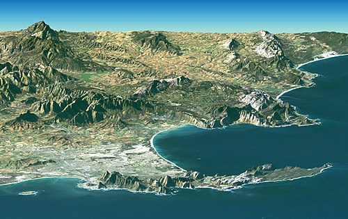
The Cape Peninsula seen from the West, False Bay (right) and Table Bay, with Robben Island (left). Compilation produced by NASA from Landsat and SRTM data. Vertical scale exaggerated.

Aerial view of the eastern False Bay coast, looking somewhat south of east: Gordon's Bay (left) to Cape Hangklip (right)