Tempe Terra is a heavily cratered highland region in the northern hemisphere of the planet Mars. Located at the northeastern edge of the Tharsis volcanic province, Tempe Terra is notable for its high degree of crustal fracturing and deformation. The region also contains many small shield volcanoes, lava flows, and other volcanic structures.
Hanging valley, as seen by HiRISE under HiWish program This may have been a waterfall at one time.
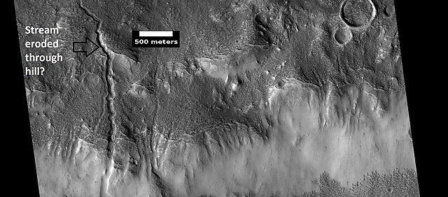
Channels, as seen by HiRISE under HiWish program. Stream appears to have eroded through a hill.
Stream meander and cutoff, as seen by HiRISE under HiWish program.
A variety of gullies originating at different levels are visible in this HiRISE image that was taken under the HiWish program.
Tharsis is a vast volcanic plateau centered near the equator in the western hemisphere of Mars. The region is home to the largest volcanoes in the Solar System, including the three enormous shield volcanoes Arsia Mons, Pavonis Mons, and Ascraeus Mons, which are collectively known as the Tharsis Montes. The tallest volcano on the planet, Olympus Mons, is often associated with the Tharsis region but is actually located off the western edge of the plateau. The name Tharsis is the Greco-Latin transliteration of the biblical Tarshish, the land at the western extremity of the known world.
MOLA topography of the Thaumasia Plateau (Syria-Thaumasia block) and southern Tharsis. The volcano shown at the left is Arsia Mons. Valles Marineris extends across the northern edge. The areas in brown have the highest elevations on the Tharsis Plateau and may be considered the "summit region" of the Tharsis bulge.
Orographic water ice clouds hover over the volcanic peaks of the central Tharsis region in this color image mosaic from Mars Global Surveyor. Olympus Mons dominates at upper left. At center are the three Tharsis Montes: Arsia Mons at bottom, Pavonis Mons at center, and Ascraeus Mons at top.
Images of ice water clouds over Tharsis taken by the ExoMars Trace Gas Orbiter, 2016