1.
Trust Territory of the Pacific Islands
–
The Trust Territory of the Pacific Islands was a United Nations trust territory in Micronesia administered by the United States from 1947 to 1986. Spain initially claimed the islands that comprised the territory of the Trust Territory of the Pacific Islands. Subsequently, Germany established competing claims over the islands, Germany, in turn, continued to retain possession until the islands were captured by Japan during World War I. The League of Nations formally placed the islands in the former South Pacific Mandate, the islands then remained under Japanese control until captured by the United States in 1944 during World War II. The TTPI entered UN trusteeship pursuant to Security Council Resolution 21 on July 18,1947 and was designated an area in its 1947 trusteeship agreement. The Territory contained 100,000 people scattered over an area the size of continental United States. They represented a variety of cultures and spoke nine languages, the Ponapeans and Kusaieans, Marshallese and Palauans, Truckese, Yapese and Chamorros had little in common, except they were in the same general area of the Pacific Ocean. The large distances between people, lack of an economy, language and cultural barriers, all worked against the union, the six district centers became upscale slums, containing deteriorated Japanese-built roads, with electricity, modern music and distractions, alienated youth and bewildered elders. The remainder of the islands stayed as they were historically, not progressing, a Congress of Micronesia first levied an income tax in 1971. It affected mainly foreigners working at bases in the region. On October 21,1986, the U. S. ended its administration of the Marshall Islands District. The termination of U. S. administration of the Chuuk, Yap, Kosrae, Pohnpei, in 1969, the 100 occupied islands comprised 700 square miles over an area of 3,000,000 square miles of sea. The latter area was comparable in size to the continental United States, the water area is about 2% of the Pacific Ocean. The population of the islands was 200,000 in the part of the 19th century. The population decreased to 100,000 by 1969 due to emigration, war, at that time, the population inhabited less than 100 out of 2,141 of the Marshall, Mariana, and Caroline Islands. The area is now divided into four jurisdictions, The following sovereign states have become associated with the United States under the Compact of Free Association
2.
League of Nations mandate
–
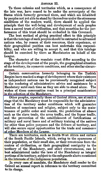
These were of the nature of both a treaty and a constitution, which contained minority rights clauses that provided for the rights of petition and adjudication by the International Court. The mandate system was established under Article 22 of the Covenant of the League of Nations, most of the remaining mandates of the League of Nations thus eventually became United Nations Trust Territories. The mandate system was established by Article 22 of the Covenant of the League of Nations, all of the territories subject to League of Nations mandates were previously controlled by states defeated in World War I, principally Imperial Germany and the Ottoman Empire. The mandates were fundamentally different from the protectorates in that the Mandatory power undertook obligations to the inhabitants of the territory, the process of establishing the mandates consisted of two phases, The formal removal of sovereignty of the state previously controlling the territory. The transfer of powers to individual states among the Allied Powers. Ottoman territorial claims were first addressed in the Treaty of Sèvres, the Turkish territories were allotted among the Allied Powers at the San Remo conference in 1920. Peace treaties have played an important role in the formation of the law of nations. Many rules that govern the relations between states have introduced and codified in the terms of peace treaties. The first twenty-six articles of the Treaty of Versailles contained the Covenant of the League of Nations and it contained the international machinery for the enforcement of the terms of the treaty. Article 22 established a system of Mandates to administer former colonies and territories, Article 22 was written two months before the signing of the peace treaty, before it was known what communities, peoples, or territories were related to sub-paragraphs 4,5, and 6. The treaty was signed, and the conference had been adjourned. The mandates were arrangements guaranteed by, or arising out of the treaty which stipulated that mandates were to be exercised on behalf of the League. The decisions taken at the conferences of the Council of Four were not made on the basis of consultation or League unanimity as stipulated by the Covenant, as a result, the actions of the conferees were viewed by some as having no legitimacy. He pointed out that the League of Nations could do nothing to alter their arrangements, since the League could only act by unanimous consent of its members – including the UK and France. United States Secretary of State Robert Lansing was a member of the American Commission to Negotiate Peace at Paris in 1919. He explained that the system of mandates was a created by the Great Powers to conceal their division of the spoils of war under the color of international law. If the former German and Ottoman territories had been ceded to the victorious powers directly, under the plan of the US Constitution the Congress was delegated the power to declare or define the Law of Nations in cases where its terms might be vague or indefinite. The US Senate refused to ratify the Covenant of the League of Nations, the legal issues surrounding the rule by force and the lack of self-determination under the system of mandates were cited by the Senators who withheld their consent
3.
League of Nations
–
The League of Nations was an intergovernmental organisation founded on 10 January 1920 as a result of the Paris Peace Conference that ended the First World War. It was the first international organisation whose mission was to maintain world peace. Its primary goals, as stated in its Covenant, included preventing wars through collective security and disarmament, at its greatest extent from 28 September 1934 to 23 February 1935, it had 58 members. The diplomatic philosophy behind the League represented a shift from the preceding hundred years. The League lacked its own armed force and depended on the Great Powers to enforce its resolutions, keep to its economic sanctions, however, the Great Powers were often reluctant to do so. Sanctions could hurt League members, so they were reluctant to comply with them, after a number of notable successes and some early failures in the 1920s, the League ultimately proved incapable of preventing aggression by the Axis powers in the 1930s. Germany withdrew from the League, as did Japan, Italy, Spain, the onset of the Second World War showed that the League had failed its primary purpose, which was to prevent any future world war. The League lasted for 26 years, the United Nations replaced it after the end of the Second World War on 20 April 1946 and inherited a number of agencies and organisations founded by the League. As historians William H. Harbaugh and Ronald E. Powaski point out, the organisation was international in scope, with a third of the members of parliaments serving as members of the IPU by 1914. Its aims were to encourage governments to solve disputes by peaceful means. Annual conferences were held to help refine the process of international arbitration. Its structure consisted of a council headed by a president, which would later be reflected in the structure of the League, at the start of the 20th century, two power blocs emerged from alliances between the European Great Powers. It was these alliances that, at the start of the First World War in 1914 and this was the first major war in Europe between industrialised countries, and the first time in Western Europe that the results of industrialisation had been dedicated to war. By the time the fighting ended in November 1918, the war had had an impact, affecting the social, political and economic systems of Europe. Anti-war sentiment rose across the world, the First World War was described as the war to end all wars, the causes identified included arms races, alliances, militaristic nationalism, secret diplomacy, and the freedom of sovereign states to enter into war for their own benefit. Goldsworthy Lowes Dickinson, a British political scientist, coined the term League of Nations in 1914, together with Lord Bryce, he played a leading role in the founding of the group of internationalist pacifists known as the Bryce Group, later the League of Nations Union. The group became more influential among the public and as a pressure group within the then governing Liberal Party. In Dickinsons 1915 pamphlet After the War he wrote of his League of Peace as being essentially an organisation for arbitration and conciliation
4.
United Nations Trusteeship Council
–
The last was Palau, formerly part of the Trust Territory of the Pacific Islands, which became a member state of the United Nations in December 1994. Those dependent territories were to be placed under the international trusteeship system created by the United Nations Charter as a successor to the League of Nations mandate system, ultimately, eleven territories were placed under trusteeship, seven in Africa and four in Oceania. Ten of the trust territories had previously been League of Nations mandates, the Trusteeship Council held its first session in March 1947. In March 1948, the United States proposed that the territory of Mandatory Palestine be placed under UN Trusteeship with the termination of the British Mandate in May 1948. However, the US did not make an effort to implement this proposal, under the Charter, the Trusteeship Council was to consist of an equal number of United Nations Member States administering trust territories and non-administering states. Thus, the Council was to consist of all U. N, over time, as trust territories attained independence, the size and workload of the Trusteeship Council was reduced and ultimately came to include only the five permanent Security Council members. The chamber itself is used for other purposes. Following a three-year refurbishment, restoring its original design by Danish architect, Finn Juhl, the formal elimination of the Trusteeship Council would require the revision of the UN Charter, which is why it has not been pursued. Other functions for the Trusteeship Council have been considered, the Commission on Global Governances 1995 report recommends an expansion of the trusteeship council. However, in March 2005, UN Secretary-General Kofi Annan proposed a reform of the United Nations. As this restructuring would involve significant changes to the UN charter, United Nations list of Non-Self-Governing Territories Homepage of the UN Trusteeship Council UN Decolonization page
5.
Namibia
–
Namibia, officially the Republic of Namibia, is a country in southern Africa whose western border is the Atlantic Ocean. It shares land borders with Zambia and Angola to the north, Botswana to the east and South Africa to the south, although it does not border Zimbabwe, a part of less than 200 metres of the Zambezi River separates the two countries. Namibia gained independence from South Africa on 21 March 1990, following the Namibian War of Independence. Its capital and largest city is Windhoek, and it is a state of the United Nations, the Southern African Development Community, the African Union. The dry lands of Namibia were inhabited since early times by the San, Damara, since about the 14th century, immigrating Bantu peoples arrived as part of the Bantu expansion. Since then the Bantu groups in total, known as the Ovambo people, have dominated the population of the country, in the late 19th century during European colonization, the German Empire established rule over most of the territory as a protectorate in 1884. It began to develop infrastructure and farming, and maintained this German colony until 1915, after the end of World War I, in 1920 the League of Nations mandated the country to the United Kingdom, under administration by South Africa. It imposed its laws, including racial classifications and rules, from 1948, with the National Party elected to power, South Africa applied apartheid also to what was known as South West Africa. In 1878 the Cape of Good Hope had annexed the port of Walvis Bay and the offshore Penguin Islands, following continued guerrilla warfare, South Africa installed an interim administration in Namibia in 1985. Namibia obtained full independence from South Africa in 1990, but Walvis Bay and the Penguin Islands remained under South African control until 1994. Namibia has a population of 2.1 million people and a stable multi-party parliamentary democracy, Agriculture, herding, tourism and the mining industry – including mining for gem diamonds, uranium, gold, silver, and base metals – form the basis of its economy. The large, arid Namib Desert has resulted in Namibia being overall one of the least densely populated countries in the world, Namibia enjoys high political, economic and social stability. The name of the country is derived from the Namib Desert, before its independence in 1990, the area was known first as German South-West Africa, then as South-West Africa, reflecting the colonial occupation by the Germans and the South Africans. The dry lands of Namibia were inhabited since early times by San, Damara, from about the 14th century, immigrating Bantu peoples arrived during the Bantu expansion from central Africa. From the late 18th century onwards, Oorlam people from Cape Colony crossed the Orange River and their encounters with the nomadic Nama tribes were largely peaceful. The missionaries accompanying the Oorlam were well received by them, the right to use waterholes, on their way further northwards, however, the Oorlam encountered clans of the Herero at Windhoek, Gobabis, and Okahandja, who resisted their encroachment. The Nama-Herero War broke out in 1880, with hostilities ebbing only after the German Empire deployed troops to the places and cemented the status quo among the Nama, Oorlam. The first Europeans to disembark and explore the region were the Portuguese navigators Diogo Cão in 1485 and Bartolomeu Dias in 1486, like most of interior Sub-Saharan Africa, Namibia was not extensively explored by Europeans until the 19th century
6.
French Cameroons
–
French Cameroons, or Cameroun, was a League of Nations Mandate territory in Equatorial Africa. It now forms part of the independent country of Cameroon, the area of present-day Cameroon came under German suzerainty during the Scramble for Africa at the end of the 19th century. The German protectorate commenced in 1884 with a treaty with local chiefs in the Douala area, in particular Ndumbe Lobe Bell, then gradually it was extended to the interior. In 1911, France ceded parts of its territory to German Cameroon, as a result of the Agadir Crisis, during World War I, the German protectorate was occupied by British and French troops, and later mandated to each country by the League of Nations in 1922. The British mandate was known as Cameroons and the French as Cameroun, following World War II each of the mandate territories was made a United Nations Trust Territory. An insurrection headed by Ruben Um Nyobé and the Union of the Peoples of Cameroon erupted in 1955, Cameroun became independent as the Republic of Cameroon in January,1960 and in October,1961 the southern part of British Cameroons joined to form the Federal Republic of Cameroon. The Muslim northern part of Cameroons had opted for union with Nigeria in May the same year, the conflict with the UPC lasted until the 1970s. After World War I, Cameroun was not integrated to French Equatorial Africa, the colonial administration also followed public health policies as well as encouraging Francophony. Charles Atangana, designed paramount chief by the Germans, and others local chiefs were invited to France, charles Atangana would visit the 1931 Paris Colonial Exhibition and attend the 1935 French Colonial Conference. France took care to make disappear all remains of German presence, French racism became prevalent throughout the colony rather quickly, and anti-French sentiment followed and would be strengthened in the late 1940s. After World War II, Cameroun was made a United Nations Trust Territory, from the beginning of the 1940s, colonial authorities encouraged a policy of agricultural diversification into monocultural crops, coffee in the west and cotton in the south. Construction of roads allowed for greater exploitation of wood, Paul Ajoulat and Alexandre Douala Manga Bell were elected deputies of the French National Assembly. Some private and public schools were opened, while the best students were sent to Dakar or France to study in college, the colonial administration also built electricity and water infrastructures in large cities. In 1952, the Representative Assembly became the Territorial Assembly of Cameroun, the Union of the Peoples of Cameroon, an anti-colonialist party created in 1948 and which struggled for unification of both Cameroons and for independence was outlawed in 1955. A colonial war then started and lasted for at least seven years, the conflict found its roots in the opposition between the settlers and the Cameroonese trade-unionists in the cities. A Cercle détudes marxistes was created by Cameroonese in 1945, soon followed by the creation of the Union of Confederate Trade Unions of Cameroon at the initiative of the CGT trade-union, conflicts erupted in September 1945, with the settlers violently debating with the French governor. Members of the USCC were arrested, in 1948, Ruben Um Nyobé became the head of the resistance movement, with a nationalist and revolutionary program. Nyobés UPC was at first only the section of the African Democratic Rally created in 1946
7.
Cameroon
–
Cameroon, officially the Republic of Cameroon, is a country in Central Africa. It is bordered by Nigeria to the west, Chad to the northeast, the Central African Republic to the east, and Equatorial Guinea, Gabon, Cameroons coastline lies on the Bight of Biafra, part of the Gulf of Guinea and the Atlantic Ocean. French and English are the languages of Cameroon. The country is referred to as Africa in miniature for its geological and cultural diversity. Natural features include beaches, deserts, mountains, rainforests, the country is well known for its native styles of music, particularly makossa and bikutsi, and for its successful national football team. Early inhabitants of the territory included the Sao civilisation around Lake Chad, portuguese explorers reached the coast in the 15th century and named the area Rio dos Camarões, which became Cameroon in English. Fulani soldiers founded the Adamawa Emirate in the north in the 19th century, Cameroon became a German colony in 1884 known as Kamerun. After World War I, the territory was divided between France and the United Kingdom as League of Nations mandates, the Union des Populations du Cameroun political party advocated independence, but was outlawed by France in the 1950s, leading to the Cameroonian Independence War. It waged war on French and UPC militant forces until 1971, in 1960, the French-administered part of Cameroon became independent as the Republic of Cameroun under President Ahmadou Ahidjo. The southern part of British Cameroons federated with it in 1961 to form the Federal Republic of Cameroon, the federation was abandoned in 1972. The country was renamed the United Republic of Cameroon in 1972, Cameroon enjoys relatively high political and social stability. This has permitted the development of agriculture, roads, railways, nevertheless, large numbers of Cameroonians live in poverty as subsistence farmers. Power lies firmly in the hands of the president since 1982, Paul Biya. The English-speaking territories of Cameroon have grown increasingly alienated from the government, politicians and civil society in English-speaking regions have called for greater decentralization and even complete separation or independence from the former French-governed territories. The territory of present-day Cameroon was first settled during the Neolithic Era, the longest continuous inhabitants are groups such as the Baka. From here, Bantu migrations into eastern, southern, and central Africa are believed to have originated about 2,000 years ago, the Sao culture arose around Lake Chad c. AD500 and gave way to the Kanem and its successor state, kingdoms, fondoms, and chiefdoms arose in the west. Portuguese sailors reached the coast in 1472 and they noted an abundance of the ghost shrimp Lepidophthalmus turneranus in the Wouri River and named it Rio dos Camarões, which became Cameroon in English
8.
British Cameroons
–
British Cameroons was a British Mandate territory in British West Africa. Today, the territory forms parts of Northern Nigeria in West Africa, the area of present-day Cameroon was claimed by Germany as a protectorate during the Scramble for Africa at the end of the 19th century. During World War I, it was occupied by British, French and Belgian troops, the French mandate was known as Cameroun and the British territory was administered as two areas, Northern Cameroons and Southern Cameroons. Northern Cameroons consisted of two sections, divided by a point where the Nigerian and Cameroun borders met. In the 1930s, most of the population consisted of Germans with Nazi sympathies. The native population of 400,000 showed little interest in volunteering for the British forces, after some discussion, a plebiscite was agreed to, and held on 11 February 1961. The Muslim-majority Northern area opted for union with Nigeria, and the Southern area voted to join Cameroon, Northern Cameroons became a region of Nigeria on 31 May 1961, while Southern Cameroons became part of Cameroon later that year on 1 October 1961. In the meantime, the area was administered as a United Kingdom Trust Territory
9.
Southern Cameroons
–
Southern Cameroons was the southern part of the British Mandate territory of British Cameroons in West Africa. Since 1984 it has been part of the Republic of Cameroon, the French mandate was known as Cameroun. The British mandate comprised two separate territories, Northern Cameroons and Southern Cameroons. They were administered from, but not joined to, the British territory of Nigeria through the British Resident with headquarters in Buea, applying the principle of indirect rule, the British allowed native authorities to administer populations according to their own traditions. These also collected taxes, which were paid over to the British. The British devoted themselves to trade, and to exploiting the economic, South Cameroons students, including Emmanuel Mbela Lifafa Endeley, created the Cameroons Youth League on 27 March 1940, to oppose what they saw as the exploitation of their country. When the League of Nations ceased to exist in 1946, most of the territories were reclassified as UN trust territories. The object of trusteeship was to prepare the lands for eventual independence, the United Nations approved the Trusteeship Agreements for British Cameroons to be governed by Britain on 6 December 1946. Southern Cameroons was divided in 1949 into two provinces, Bamenda and Southern, following the Ibadan General Conference of 1950, a new constitution for Nigeria devolved more power to the regions. In the subsequent election thirteen Southern Cameroonian representatives were elected to the Eastern Nigerian House of Assembly in Enugu, at a conference in London from 30 July to 22 August 1953, the Southern Cameroons delegation asked for a separate region of its own. The British agreed, and Southern Cameroons became a region with its capital still at Buea. Elections were held in 1954 and the parliament met on 1 October 1954, as Cameroun and Nigeria prepared for Independence, South Cameroons nationalists debated whether their best interests lay with union with Cameroun, union with Nigeria or total independence. Endeley was defeated in elections on 1 February 1959 by John Ngu Foncha, the United Nations organised a plebiscite in the Cameroons on 11 February 1961 which put two alternatives to the people, union with Nigeria or union with Cameroun. The third option, independence, was opposed by the UK representative to the UN Trusteeship Council, Sir Andrew Cohen, in the plebiscite, Northern Cameroons voted for union with Nigeria, and Southern Cameroons for union with Cameroun. Southern Cameroons became part of Cameroon on 1 October 1961, Foncha served as Prime Minister of West Cameroun and Vice-President of the Federal Republic of Cameroun. However, the English-speaking peoples of the Southern Cameroons did not believe that they were treated by the French-speaking government of the country. Following a referendum on 20 May 1972, a new constitution was adopted in Cameroun which replaced the state with a unitary state. Southern Cameroons lost its autonomous status and became the Northwest Province, the Southern Cameroonians felt further marginalised
10.
Referendum
–
A referendum is a direct vote in which an entire electorate is asked to vote on a particular proposal. This may result in the adoption of a new law, in some countries it is synonymous with a plebiscite or a vote on a ballot question. Some definitions of plebiscite suggest that it is a type of vote to change the constitution or government of a country, however, some other countries define it differently. For example, Australia defines referendum as a vote to change the constitution, the addition of the verb sum to a gerundive, denotes the idea of necessity or compulsion, that which must be done, rather than that which is fit for doing). This determines the form of the plural in English, which according to English grammar should be referendums, the use of referenda as a plural form in English is thus insupportable according to the rules of both Latin and English grammar alike. The Latin plural gerundive referenda, meaning things to be referred, compare also, Agenda those matters which must be driven forward, from ago, to drive, Memorandum, that matter which must be remembered, from memoro, to call to mind, etc. The name and use of the referendum is thought to have originated in the Swiss canton of Graubünden as early as the 16th century. Today, a referendum can also often be referred to as a plebiscite, for example, Australia defines referendum as a vote to change the constitution, and plebiscite as a vote that does not affect the constitution. In contrast, Ireland has only held one plebiscite, which was the vote to adopt its constitution. Of that which has most definitely already occurred and this is in line with Eamon De Valeras oft stated belief that the people do not have the right to do wrong which in this context means to reject his new Eire constitution. The term referendum covers a variety of different meanings, a referendum can be binding or advisory. In some countries, different names are used for two types of referendum. From a political-philosophical perspective, referendums are an expression of direct democracy, however, in the modern world, most referendums need to be understood within the context of representative democracy. Australia ranked second with dozens of referendums, a referendum usually offers the electorate a choice of accepting or rejecting a proposal, but this is not necessarily the case. In Switzerland, for example, multiple choice referendums are common and this question can be resolved by applying voting systems designed for single winner elections to a multiple-choice referendum. Swiss referendums get around this problem by offering a separate vote on each of the options as well as an additional decision about which of the multiple options should be preferred. In the Swedish case, in both referendums the winning option was chosen by the Single Member Plurality system, in other words, the winning option was deemed to be that supported by a plurality, rather than an absolute majority, of voters. In the 1977, Australian referendum, the winner was chosen by the system of preferential instant-runoff voting, the 1992 New Zealand poll, was counted under the two-round system, as were polls in Newfoundland and Guam, for example
11.
Nigeria
–
Its coast in the south lies on the Gulf of Guinea in the Atlantic Ocean. It comprises 36 states and the Federal Capital Territory, where the capital, Nigeria is officially a democratic secular country. Modern-day Nigeria has been the site of numerous kingdoms and tribal states over the millennia, the modern state originated from British colonial rule beginning in the 19th century, and the merging of the Southern Nigeria Protectorate and Northern Nigeria Protectorate in 1914. The British set up administrative and legal structures whilst practising indirect rule through traditional chiefdoms, Nigeria became a formally independent federation in 1960, and plunged into a civil war from 1967 to 1970. Nigeria is often referred to as the Giant of Africa, owing to its large population, with approximately 184 million inhabitants, Nigeria is the most populous country in Africa and the seventh most populous country in the world. Nigeria has one of the largest populations of youth in the world, Nigeria is divided roughly in half between Christians, who live mostly in the southern part of the country, and Muslims in the northern part. A minority of the population practise religions indigenous to Nigeria, such as native to the Igbo. As of 2015, Nigeria is the worlds 20th largest economy, worth more than $500 billion and $1 trillion in terms of nominal GDP and it overtook South Africa to become Africas largest economy in 2014. The 2013 debt-to-GDP ratio was 11 percent, Nigeria is a member of the MINT group of countries, which are widely seen as the globes next BRIC-like economies. It is also listed among the Next Eleven economies set to become among the biggest in the world, Nigeria is a founding member of the African Union and a member of many other international organizations, including the United Nations, the Commonwealth of Nations and OPEC. The name Nigeria was taken from the Niger River running through the country and this name was coined in the late 19th century by British journalist Flora Shaw, who later married Lord Lugard, a British colonial administrator. The origin of the name Niger, which applied only to the middle reaches of the Niger River, is uncertain. The word is likely an alteration of the Tuareg name egerew n-igerewen used by inhabitants along the middle reaches of the river around Timbuktu prior to 19th-century European colonialism. The Nok civilisation of Northern Nigeria flourished between 500 BC and AD200, producing life-sized terracotta figures which are some of the earliest known sculptures in Sub-Saharan Africa, further north, the cities Kano and Katsina have a recorded history dating to around 999 AD. Hausa kingdoms and the Kanem-Bornu Empire prospered as trade posts between North and West Africa, the Kingdom of Nri of the Igbo people consolidated in the 10th century and continued until it lost its sovereignty to the British in 1911. Nri was ruled by the Eze Nri, and the city of Nri is considered to be the foundation of Igbo culture, Nri and Aguleri, where the Igbo creation myth originates, are in the territory of the Umeuri clan. Members of the clan trace their lineages back to the patriarchal king-figure Eri, in West Africa, the oldest bronzes made using the lost-wax process were from Igbo Ukwu, a city under Nri influence. The Yoruba kingdoms of Ife and Oyo in southwestern Nigeria became prominent in the 12th and 14th centuries, the oldest signs of human settlement at Ifes current site date back to the 9th century, and its material culture includes terracotta and bronze figures
12.
Territory of Papua and New Guinea
–
The Territory of Papua and New Guinea was established by an administrative union between the Australian-administered territories of Papua and New Guinea in 1949. In 1972, the name of the Territory changed to Papua New Guinea, archeological evidence suggests that humans arrived on New Guinea around 50,000 years ago. These Melanesian people developed stone tools and agriculture, portuguese and Spanish navigators sailing in the South Pacific entered New Guinea waters in the early part of the 16th century and in 1526–27, Jorge de Menezes came upon the principal island Papua. In 1545, the Spaniard Iñigo Ortiz de Retes gave the island the name New Guinea because of what he saw as a resemblance between the inhabitants and those found on the African Guinea coast. Knowledge of the interior of the island remained scant for several centuries after these initial European encounters, in 1884, Germany formally took possession of the northeast quarter of the island and it became known as German New Guinea. In 1884, a British protectorate was proclaimed over Papua – the southern coast of New Guinea and they are as necessary to Australia as water to a city. Shortly after the start of the Pacific War, the island of New Guinea was invaded by the Japanese, most of West Papua, at that time known as Dutch New Guinea, was occupied, as were large parts of the Territory of New Guinea. The New Guinea campaign was a campaign of the Pacific War. In all, some 200,000 Japanese soldiers, sailors, major battles included the Battle of Kokoda Trail, Battle of Buna-Gona and Battle of Milne Bay. The offensives in Papua and New Guinea of 1943–44 were the single largest series of connected operations ever mounted by the Australian armed forces, bitter fighting continued in New Guinea between the Allies and the Japanese 18th Army based in New Guinea until the Japanese surrender in 1945. The Papua and New Guinea Act 1949 united, for administrative purposes only, the Territory of Papua and it also provided for a Legislative Council, a judicial organization, a public service, and a system of local government. The House of Assembly replaced the Legislative Council in 1963, in 1972, the name of the territory was changed to Papua New Guinea. Under Australian Minister for External Territories Andrew Peacock, the territory adopted self-government in 1972,1972 elections saw the formation of a ministry headed by Chief Minister Michael Somare, who pledged to lead PNG to self-government and then to independence. History of Papua New Guinea History of Nauru – the other League of Nations mandate and United Nations Trust Territory of Australia
13.
Territory of Papua
–
The Territory of Papua comprised the southeastern quarter of the island of New Guinea from 1883 to 1975. In 1883, the Government of Queensland annexed this territory for the British Empire, the United Kingdom Government refused to ratify the annexation but in 1884 a Protectorate was proclaimed over the territory, then called British New Guinea. There is an ambiguity about the exact date on which the entire territory was annexed by the British. The Papua Act 1905 recites that this happened on or about 4 September 1888, on 18 March 1902, the Territory was placed under the authority of the Commonwealth of Australia. Resolutions of acceptance were passed by the Commonwealth Parliament, who accepted the territory under the name of Papua, in 1949, the Territory and the Territory of New Guinea were established in an administrative union by the name of the Territory of Papua and New Guinea. That administrative union was renamed as Papua New Guinea in 1971 and this important legal and political distinction remained until the advent of the Independent State of Papua New Guinea in 1975. Papua made up half of the current-day Papua New Guinea and contained the territorys capital, Port Moresby. Archeological evidence suggests that humans arrived on New Guinea at least 60,000 years ago and these Melanesian people developed stone tools and agriculture. In 1545, the Spaniard Íñigo Ortiz de Retez gave the island the name New Guinea owing to what he saw as a resemblance between the inhabitants and those found on the African Guinea coast. Knowledge of the interior of the island remained scant for several centuries after these initial European encounters, chester made the proclamation on 4 April 1883, but the British government repudiated the action. On 6 November 1884, after the Australian colonies had promised financial support, on 4 September 1888 it was annexed, together with some adjacent islands, by Britain as British New Guinea. In 1902, Papua was effectively transferred to the authority of the new British dominion of Australia, with the passage of the Papua Act of 1905, the area was officially renamed the Territory of Papua, and Australian administration became formal in 1906. At the outbreak of the First World War in 1914 Australia captured Kaiser-Wilhelmsland following the landing on 11 September 1914 of the 2000 man Australian Naval, the Australian takeover of New Guinea was formalised by the Treaty of Versailles in 1919. Shortly after the start of the Pacific War, the island of New Guinea was invaded by the Japanese, Papua was the least affected region. Civil administration was suspended during the war and both territories were placed under martial law for the duration, the New Guinea campaign opened with the battles for New Britain and New Ireland in the Territory of New Guinea in 1942. From July 1942, a few Australian reserve battalions, many of them young and untrained, fought a stubborn rearguard action against the Japanese attack. In early September 1942 Japanese marines attacked a strategic Royal Australian Air Force base at Milne Bay and they were beaten back by the Australian Army, and the Battle of Milne Bay is remembered as the first outright defeat of Japanese land forces during World War II. The offensives in Papua and New Guinea of 1943–44 were the single largest series of connected operations ever mounted by the Australian armed forces, bitter fighting continued in New Guinea between the largely Australian force and the Japanese 18th Army based in New Guinea until the Japanese surrender in 1945
14.
Territory of New Guinea
–
The Territory of New Guinea was an Australian administered territory on the island of New Guinea from 1920 until 1975. In 1949, the Territory and the Territory of Papua were established in a union by the name of the Territory of Papua. That administrative union was renamed as Papua New Guinea in 1971, the initial Australian mandate was based on the previous German New Guinea, which had been captured and occupied by Australian forces during World War I. Most of the Territory of New Guinea was occupied by Japan during World War II, during this time, Rabaul, on the island of New Britain, became a major Japanese base. After World War II, the territories of Papua and New Guinea were combined in a union under the Papua New Guinea Provisional Administration Act. Archeological evidence suggests that humans arrived on New Guinea at least 60,000 years ago and these Melanesian people developed stone tools and agriculture. In 1545, the Spaniard Iñigo Ortiz de Retes gave the island the name New Guinea because of what he saw as a resemblance between the inhabitants and those found on the African Guinea coast. Knowledge of the interior of the island remained scant for several centuries after these initial European encounters, in 1884, Germany formally took possession of the northeast quarter of the island and it became known as German New Guinea. In 1884, a British protectorate was proclaimed over Papua – the southern coast of New Guinea, Germany administered several territories in the south and central Pacific which the British requested be captured by Australian and New Zealand forces. Rabaul was occupied, unopposed, on 12 September, the German administration surrendered German New Guinea on 17 September. The colony remained under Australian military control until 1921 and they are as necessary to Australia as water to a city. Article 22 of the Treaty of Versailles provided for the division of Germany, in the Pacific, Japan gained Germany’s islands north of the equator and Kiautschou in China. Article 22 said, The British Government, on behalf of Australia, the terms of the mandate were not received in Australia until April 1921. Shortly after the start of the Pacific War, the island of New Guinea was invaded by the Japanese, the New Guinea campaign opened with the battles for New Britain and New Ireland in the Territory of New Guinea in 1942. Local Papuans, called Fuzzy Wuzzy Angels by the Australians, assisted and escorted injured Australian troops down the Kokoda track, the bitter Battle of Buna-Gona followed in which Australian and United States forces attacked the main Japanese beachheads in New Guinea, at Buna, Sanananda and Gona. Facing tropical disease, difficult terrain and well-constructed Japanese defences, the allies finally achieved victory after experiencing heavy casualties, the offensives in Papua and New Guinea of 1943–44 were the single largest series of connected operations ever mounted by the Australian armed forces. Bitter fighting continued in New Guinea between the largely Australian force and the Japanese 18th Army based in New Guinea until the Surrender of Japan to end the war on September 2,1945, the New Guinea campaign was a major campaign of the Pacific War. In all, some 200,000 Japanese soldiers, sailors, the Papua and New Guinea Act 1949 united the Territory of Papua and the Territory of New Guinea as the Territory of Papua and New Guinea
15.
Papua New Guinea
–
Its capital, located along its southeastern coast, is Port Moresby. The western half of New Guinea forms the Indonesian provinces of Papua, Papua New Guinea is one of the most culturally diverse countries in the world. There are 852 known languages in the country, of which 12 have no known living speakers, most of the population of more than 7 million people live in customary communities, which are as diverse as the languages. It is also one of the most rural, as only 18 percent of its live in urban centres. The country is one of the worlds least explored, culturally and geographically and it is known to have numerous groups of uncontacted peoples, and researchers believe there are many undiscovered species of plants and animals in the interior. Papua New Guinea is classified as an economy by the International Monetary Fund. Strong growth in Papua New Guineas mining and resource sector led to the becoming the sixth fastest-growing economy in the world in 2011. Growth was expected to slow once major resource projects came on line in 2015, mining remains a major economic factor, however. Local and national governments are discussing the potential of resuming mining operations in Panguna mine in Bougainville Province, nearly 40 percent of the population lives a self-sustainable natural lifestyle with no access to global capital. Most of the still live in strong traditional social groups based on farming. Their social lives combine traditional religion with modern practices, including primary education, at the national level, after being ruled by three external powers since 1884, Papua New Guinea established its sovereignty in 1975. This followed nearly 60 years of Australian administration, which started during the Great War and it became an independent Commonwealth realm with Queen Elizabeth II as its head of state and became a member of the Commonwealth of Nations in its own right. Archaeological evidence indicates that humans first arrived in Papua New Guinea around 42,000 to 45,000 years ago and they were descendants of migrants out of Africa, in one of the early waves of human migration. Agriculture was independently developed in the New Guinea highlands around 7000 BC, a major migration of Austronesian-speaking peoples to coastal regions of New Guinea took place around 500 BC. This has been correlated with the introduction of pottery, pigs, in the 18th century, traders brought the sweet potato to New Guinea, where it was adopted and became part of the staples. Portuguese traders had obtained it from South America and introduced it to the Moluccas, the far higher crop yields from sweet potato gardens radically transformed traditional agriculture and societies. Sweet potato largely supplanted the previous staple, taro, and resulted in a significant increase in population in the highlands. In 1901, on Goaribari Island in the Gulf of Papua, missionary Harry Dauncey found 10,000 skulls in the islands Long Houses, traders from Southeast Asia had visited New Guinea beginning 5,000 years ago to collect bird of paradise plumes
16.
Western New Guinea
–
Western New Guinea, formerly known as Irian Jaya, is the Indonesian part of the island of New Guinea, lying to the west of the nation of Papua New Guinea. The territory is considered to include smaller nearby islands including Biak, the region is predominantly dense forest where numerous traditional tribes live such as the Dani of the Baliem Valley, although the majority of the population live in or near coastal areas. The largest city in the region is Jayapura, the official and most commonly spoken language is Indonesian. Estimates of the number of languages in the region range from 200 to over 700, with the most widely spoken including Dani, Yali, Ekari. The predominant religion is Christianity followed by Islam, the main industries include agriculture, fishing, oil production, and mining. The territory has been part of Indonesia since May 1963, human habitation is estimated to have begun between 42,000 and 48,000 years ago. The Netherlands claimed the region and commenced work in the nineteenth century. The region was annexed by Indonesia in the 1960s, following the 1998 commencement of reforms across Indonesia, Papua and other Indonesian provinces received greater regional autonomy. In 2001, Special Autonomy status was granted to Papua province, although to date, implementation has been partial, the region was administered as a single province until 2003, when it was split into the provinces of Papua and West Papua. Speakers align themselves with a political orientation when choosing a name for the half of the island of New Guinea. West Papua, which is not the name for the western half of the island, is preferred by ethnic Papuans. The region has had the names of Netherlands New Guinea, West New Guinea, West Irian, Irian Jaya. Indonesian president Abdurrahman Wahid considered his use of the name Papua in 2002 as a concession to the West Papuans. Since 2003, western New Guinea has had two provinces, the province of West Papua on the west, and the province of Papua on the east, officials and administrators refer to the province when they say West Papua, independence activists mean the whole of western New Guinea. The region is 1,200 kilometres from east to west and 736 kilometres from north to south and it has an area of 420,540 square kilometres, which equates to approximately 22% of Indonesias land area. The border with Papua New Guinea mostly follows the 141st meridian east, the island of New Guinea was once part of the Australian landmass and lie on the Sahul. The collision between the Indo-Australian Plate and Pacific plate resulting in the Maoke Mountains run through the centre of the region and are 600 km long and 100 km across. The range includes about ten peaks over 4,000 metres, including Puncak Jaya, Puncak Mandala, the range ensures a steady supply of rain from the tropical atmosphere
17.
New Guinea
–
New Guinea is a large Island in the South West Pacific region. It is the worlds second-largest island, after Greenland, covering an area of 785,753 km2. The island is divided between two countries, Papua New Guinea to the east, and Indonesia to the west, the island has been known by various names. The name Papua was used to refer to parts of the island before contact with the West and its etymology is unclear, one theory states that it is from Tidore, the language used by the Sultanate of Tidore, which controlled parts of the islands coastal region. The name came from papo and ua, which means not united or, ploeg reports that the word papua is often said to derive from the Malay word papua or pua-pua, meaning frizzly-haired, referring to the highly curly hair of the inhabitants of these areas. When the Portuguese and Spanish explorers arrived in the island via the Spice Islands, when the Dutch colonized it as part of Netherlands East Indies, they called it Nieuw Guinea. The name Irian was used in the Indonesian language to refer the island and Indonesian province, the name was promoted in 1945 by Marcus Kaisiepo, brother of the future governor Frans Kaisiepo. It is taken from the Biak language of Biak Island, and means to rise and this name of Irian is the name used in the Biak language and other languages such as Serui, Merauke and Waropen. The name was used until 2001, when the name Papua was again used for the island, the name Irian, which was originally favored by natives, is now considered to be a name imposed by the authority of Jakarta. New Guinea is an island to the north of Australia, and it is isolated by the Arafura Sea to the west and the Torres Strait and Coral Sea to the east. A spine of east–west mountains, the New Guinea Highlands, dominates the geography of New Guinea, stretching over 1,600 km from the head to the tail of the island. The western half of the island of New Guinea contains the highest mountains in Oceania, rising up to 4,884 m high, the tree line is around 4,000 m elevation and the tallest peaks contain permanent equatorial glaciers—which have been retreating since at least 1936. Various other smaller mountain ranges occur both north and west of the central ranges, except in high elevations, most areas possess a warm humid climate throughout the year, with some seasonal variation associated with the northeast monsoon season. At 4,884 metres, Puncak Jaya makes New Guinea the worlds fourth highest landmass, Puncak Mandala, located in Papua, is the second highest peak on the island at 4,760 metres. Puncak Trikora, also in Papua, is 4,750 metres, mount Wilhelm is the highest peak on the PNG side of the border at 4,509 metres. Its granite peak is the highest point of the Bismarck Range, mount Giluwe 4,368 metres is the second highest summit in PNG. It is also the highest volcanic peak in Oceania, another major habitat feature is the vast southern and northern lowlands. Stretching for hundreds of kilometres, these include lowland rainforests, extensive wetlands, savanna grasslands, the southern lowlands are the site of Lorentz National Park, also a UNESCO World Heritage Site
18.
Indonesia
–
Indonesia, officially the Republic of Indonesia, is a unitary sovereign state and transcontinental country located mainly in Southeast Asia with some territories in Oceania. Situated between the Indian and Pacific oceans, it is the worlds largest island country, with more than seventeen thousand islands. At 1,904,569 square kilometres, Indonesia is the worlds 14th-largest country in terms of area and worlds 7th-largest country in terms of combined sea. It has an population of over 260 million people and is the worlds fourth most populous country. The worlds most populous island, Java, contains more than half of the countrys population, Indonesias republican form of government includes an elected legislature and president. Indonesia has 34 provinces, of which five have Special Administrative status and its capital and countrys most populous city is Jakarta, which is also the most populous city in Southeast Asia and the second in Asia. The country shares land borders with Papua New Guinea, East Timor, other neighbouring countries include Singapore, Vietnam, the Philippines, Australia, Palau, and the Indian territory of the Andaman and Nicobar Islands. Despite its large population and densely populated regions, Indonesia has vast areas of wilderness that support the second highest level of biodiversity. The country has abundant natural resources like oil and natural gas, tin, copper, agriculture mainly produces rice, palm oil, tea, coffee, cacao, medicinal plants, spices and rubber. Indonesias major trading partners are Japan, United States, China, the Indonesian archipelago has been an important region for trade since at least the 7th century, when Srivijaya and then later Majapahit traded with China and India. Local rulers gradually absorbed foreign cultural, religious and political models from the early centuries CE, Indonesian history has been influenced by foreign powers drawn to its natural resources. Indonesia consists of hundreds of native ethnic and linguistic groups. The largest – and politically dominant – ethnic group are the Javanese, a shared identity has developed, defined by a national language, ethnic diversity, religious pluralism within a Muslim-majority population, and a history of colonialism and rebellion against it. Indonesias national motto, Bhinneka Tunggal Ika, articulates the diversity that shapes the country, Indonesias economy is the worlds 16th largest by nominal GDP and the 8th largest by GDP at PPP, the largest in Southeast Asia, and is considered an emerging market and newly industrialised country. Indonesia has been a member of the United Nations since 1950, Indonesia is a member of the G20 major economies and World Trade Organization. The name Indonesia derives from the Greek name of the Indós, the name dates to the 18th century, far predating the formation of independent Indonesia. In 1850, George Windsor Earl, an English ethnologist, proposed the terms Indunesians—and, his preference, in the same publication, one of his students, James Richardson Logan, used Indonesia as a synonym for Indian Archipelago. However, Dutch academics writing in East Indies publications were reluctant to use Indonesia, they preferred Malay Archipelago, the Netherlands East Indies, popularly Indië, the East, and Insulinde
19.
Ruanda-Urundi
–
Ruanda-Urundi was a territory in the African Great Lakes region, once part of German East Africa, which was ruled by Belgium between 1916 and 1962. After the disestablishment of the League and World War II, Ruanda-Urundi became a Trust Territory of the United Nations, in 1962, the mandate became independent as the two separate countries of Rwanda and Burundi. Before the Scramble for Africa, the region of Ruanda-Urundi was dominated by two independent kingdoms, Rwanda and Burundi, which were annexed by the German Empire in 1894, the Ruanda-Urundi region formed the westernmost part of the colony of German East Africa, which included modern-day mainland Tanzania. After the outbreak of World War I in 1914, Ruanda-Urundi was the scene of fighting between German and Belgian forces from the Belgian Congo which bordered the region to the west, the Treaty of Versailles divided the German colonial empire among the Allied nations. German East Africa was divided, with the vast majority of the territory, known as Tanganyika, going to the British, the western part of the colony, formally referred to as the Belgian Occupied East African Territories, was allocated to Belgium. In 1924, when the League of Nations issued a formal mandate granting Belgium full control over the area, the Belgians were far more involved in the territory than the Germans, especially in Ruanda. These funds mostly came from the cultivation of coffee in the regions rich volcanic soils. To implement their vision, the Belgians used the indigenous power structure. This consisted of a largely Tutsi ruling class controlling a mostly Hutu population, the Belgian administrators believed that the Tutsi were superior and deserved power. While before colonization the Hutu had played some role in governance, Hutu anger at the Tutsi domination was largely focused on the Tutsi elite rather than the distant colonial power. Although promising the League it would promote education, Belgium left the task to subsidised Catholic missions, as late as 1961, shortly before independence arrived, fewer than 100 natives had been educated beyond secondary level. He must be cured of his thoughtlessness, he must accustom himself to living in society, after the League of Nations was dissolved, the region became a United Nations trust territory in 1946. Independence came largely as a result of actions elsewhere, in the late 1950s, an independence movement arose in the Belgian Congo, and the Belgians became convinced they could no longer control the territory. Unrest also broke out in Ruanda where the king was deposed, in 1960, Ruanda-Urundis larger neighbour gained its independence. After two more years of hurried preparations, the trust territory became independent on 1 July 1962, broken up along traditional lines as the independent nations of Rwanda and it took two more years before the government of the two became wholly separate. The Great Lakes of Africa, Two Thousand Years of History, le Burundi sous administration Belge, la période du mandat, 1919-1939
20.
Belgium
–
Belgium, officially the Kingdom of Belgium, is a sovereign state in Western Europe bordered by France, the Netherlands, Germany, Luxembourg, and the North Sea. It is a small, densely populated country which covers an area of 30,528 square kilometres and has a population of about 11 million people. Additionally, there is a group of German-speakers who live in the East Cantons located around the High Fens area. Historically, Belgium, the Netherlands and Luxembourg were known as the Low Countries, the region was called Belgica in Latin, after the Roman province of Gallia Belgica. From the end of the Middle Ages until the 17th century, today, Belgium is a federal constitutional monarchy with a parliamentary system of governance. It is divided into three regions and three communities, that exist next to each other and its two largest regions are the Dutch-speaking region of Flanders in the north and the French-speaking southern region of Wallonia. The Brussels-Capital Region is a bilingual enclave within the Flemish Region. A German-speaking Community exists in eastern Wallonia, Belgiums linguistic diversity and related political conflicts are reflected in its political history and complex system of governance, made up of six different governments. Upon its independence, declared in 1830, Belgium participated in the Industrial Revolution and, during the course of the 20th century, possessed a number of colonies in Africa. This continuing antagonism has led to several far-reaching reforms, resulting in a transition from a unitary to a federal arrangement during the period from 1970 to 1993. Belgium is also a member of the Eurozone, NATO, OECD and WTO. Its capital, Brussels, hosts several of the EUs official seats as well as the headquarters of major international organizations such as NATO. Belgium is also a part of the Schengen Area, Belgium is a developed country, with an advanced high-income economy and is categorized as very high in the Human Development Index. A gradual immigration by Germanic Frankish tribes during the 5th century brought the area under the rule of the Merovingian kings, a gradual shift of power during the 8th century led the kingdom of the Franks to evolve into the Carolingian Empire. Many of these fiefdoms were united in the Burgundian Netherlands of the 14th and 15th centuries, the Eighty Years War divided the Low Countries into the northern United Provinces and the Southern Netherlands. The latter were ruled successively by the Spanish and the Austrian Habsburgs and this was the theatre of most Franco-Spanish and Franco-Austrian wars during the 17th and 18th centuries. The reunification of the Low Countries as the United Kingdom of the Netherlands occurred at the dissolution of the First French Empire in 1815, although the franchise was initially restricted, universal suffrage for men was introduced after the general strike of 1893 and for women in 1949. The main political parties of the 19th century were the Catholic Party, French was originally the single official language adopted by the nobility and the bourgeoisie
21.
Belgian Congo
–
The Belgian Congo was a Belgian colony in Central Africa between 1908 and 1960 in what is now the Democratic Republic of the Congo. Colonial rule in the Congo began in the late 19th century, King Leopold II of the Belgians persuaded the government to support colonial expansion around the then-largely unexplored Congo Basin. Their ambivalence resulted in Leopolds creating a colony on his own account, with support from a number of Western countries, Leopold achieved international recognition for a personal colony, the Congo Free State, in 1885. Belgian rule in the Congo was based on the trinity of state, missionary. The privileging of Belgian commercial interests meant that large amounts of capital flowed into the Congo, the country was split into nesting, hierarchically organised administrative subdivisions, and run uniformly according to a set native policy. This was in contrast to the British and the French, who favoured the system of indirect rule whereby traditional leaders were retained in positions of authority under colonial oversight. The Congo had a degree of racial segregation. The large numbers of immigrants who moved to the Congo after the end of World War II came from across the social spectrum. During the 1940s and 1950s, the Congo had extensive urbanisation, one of the results was the development of a new middle class of Europeanised African évolués in the cities. By the 1950s the Congo had a labour force twice as large as that in any other African colony. This ended with the seizure of power by Joseph-Désiré Mobutu, until the later part of the 19th century, few Europeans had ventured into the Congo basin. The rainforest, swamps and accompanying malaria and other diseases, such as sleeping sickness. After Henry Morton Stanley had explored the region in a journey that ended in 1878, Leopold courted the explorer, Leopold II had been keen to acquire a colony for Belgium even before he ascended to the throne in 1865. The Belgian civil government showed little interest in its monarchs dreams of empire-building, ambitious and stubborn, Leopold decided to pursue the matter on his own account. European rivalry in Central Africa led to tensions, in particular with regard to the largely unclaimed Congo River basin. In November 1884 Otto von Bismarck convened a 14-nation conference to find a resolution to the Congo crisis. The rules recognised the Congo basin as a free-trade zone, but Leopold II emerged triumphant from the Berlin Conference and his single-shareholder philanthropic organization received a large share of territory to be organized as the Congo Free State. The Congo Free State operated as a corporate state privately controlled by Leopold II through a non-governmental organization, the state included the entire area of the present Democratic Republic of the Congo and existed from 1885 to 1908, when the government of Belgium annexed the area
22.
Rwanda
–
Rwanda, officially the Republic of Rwanda, is a sovereign state in central and east Africa and one of the smallest countries on the African mainland. Located a few south of the Equator, Rwanda is bordered by Uganda, Tanzania, Burundi. Rwanda is in the African Great Lakes region and is elevated, its geography is dominated by mountains in the west and savanna to the east. The climate is temperate to subtropical, with two seasons and two dry seasons each year. The population is young and predominantly rural, with a density among the highest in Africa, Rwandans are drawn from just one cultural and linguistic group, the Banyarwanda, although within this group there are three subgroups, the Hutu, Tutsi and Twa. The Twa are a pygmy people descended from Rwandas earliest inhabitants. Christianity is the largest religion in the country, the language is Kinyarwanda, spoken by most Rwandans, with English. Rwanda has a system of government. The president is Paul Kagame of the Rwandan Patriotic Front, who took office in 2000, Rwanda today has low corruption compared with neighbouring countries, although human rights organisations report suppression of opposition groups, intimidation and restrictions on freedom of speech. The country has been governed by an administrative hierarchy since pre-colonial times. Rwanda is one of two countries with a female majority in the national parliament. Hunter gatherers settled the territory in the stone and iron ages, the population coalesced first into clans and then into kingdoms. The Kingdom of Rwanda dominated from the century, with the Tutsi kings conquering others militarily, centralising power. Germany colonised Rwanda in 1884 as part of German East Africa, followed by Belgium, both European nations ruled through the kings and perpetuated a pro-Tutsi policy. The Hutu population revolted in 1959 and they massacred numerous Tutsi and ultimately established an independent, Hutu-dominated state in 1962. The Tutsi-led Rwandan Patriotic Front launched a war in 1990. Social tensions erupted in the 1994 genocide, in which Hutu extremists killed an estimated 500,000 to 1.3 million Tutsi, the RPF ended the genocide with a military victory. Rwandas economy suffered heavily during the 1994 Rwandan Genocide, but has since strengthened, the economy is based mostly on subsistence agriculture
23.
Burundi
–
It is also considered part of Central Africa. The southwestern border is adjacent to Lake Tanganyika, the Twa, Hutu and Tutsi peoples have lived in Burundi for at least 500 years. For more than 200 of those years, Burundi was an independent kingdom, until the beginning of the twentieth century, after the First World War and Germanys defeat, it ceded the territory to Belgium. Both Germans and Belgians ruled Burundi and Rwanda as a European colony known as Ruanda-Urundi, despite common misconceptions, Burundi and Rwanda had never been under common rule until the time of European colonisation. The European intervention exacerbated social differences between the Tutsi and Hutu, and contributed to political unrest in the region. Bouts of ethnic cleansing and ultimately two civil wars and genocides during the 1970s and again in the 1990s left the country undeveloped, Burundis political system is that of a presidential representative democratic republic based upon a multi-party state. The President of Burundi is the head of state and head of government, there are currently 21 registered parties in Burundi. On 13 March 1992, Tutsi coup leader Pierre Buyoya established a constitution, six years later, on 6 June 1998, the constitution was changed, broadening National Assemblys seats and making provisions for two vice-presidents. Because of the Arusha Accord, Burundi enacted a government in 2000. In October 2016, Burundi informed the UN of its intention to withdraw from the International Criminal Court, Burundi remains an overwhelmingly rural society, with just 13% of the population living in urban areas in 2013. The population density of around 315 people per kilometre is the second highest in Sub-Saharan Africa. Roughly 85% of the population are of Hutu ethnic origin, 15% are Tutsi, the official languages of Burundi are French and Kirundi, although Swahili can be found spoken along the Tanzanian border. One of the smallest countries in Africa, Burundi has an equatorial climate, Burundi is a part of the Albertine Rift, the western extension of the East African Rift. The country lies on a plateau in the centre of Africa. The highest peak, Mount Heha at 2,685 m, lies to the southeast of the capital, there are two national parks, Kibira National Park to the northwest, Ruvubu National Park to the northeast. Both were established in 1982 to conserve wildlife populations, Burundis lands are mostly agricultural or pasture. Settlement by rural populations has led to deforestation, soil erosion, deforestation of the entire country is almost completely due to overpopulation, with a mere 600 km2 remaining and an ongoing loss of about 9% per annum. In addition to poverty, Burundians often have to deal with corruption, weak infrastructure, poor access to health and education services, Burundi is densely populated and has had substantial emigration as young people seek opportunities elsewhere
24.
Tanganyika (territory)
–
Tanganyika was a territory administered by the United Kingdom from 1916 until 1961. The UK initially administered the territory as a power with the Royal Navy. From 20 July 1922, British administration was formalised by Tanganyika being created a British League of Nations mandate, from 1946, it was administered by the UK as a United Nations trust territory. Before the end of the First World War the territory was part of the German colony of German East Africa, after the war had broken out, the British invaded German East Africa, but were unable to defeat the German Army. After this the League of Nations gave control of the area to the United Kingdom who named their part of the earlier German area Tanganyika. The United Kingdom held Tanganyika as a League of Nations mandate until the end of the Second World War after which it was held as a United Nations trust territory, in 1961, Tanganyika gained its independence from the United Kingdom as Tanganyika, a Commonwealth realm. It became a republic a year later but stayed in the Commonwealth of Nations, Tanganyika now forms part of the modern-day state of Tanzania. The name Tanganyika is derived from the Swahili words tanga and nyika and it might, therefore, be understood as a description of using Lake Tanganyika, sail in the wilderness. In the second half of the 19th century, to European explorers and colonialists penetrating the African interior from Zanzibar, in 1885, Germany declared that it intended to establish a protectorate, named German East Africa in the area, under the leadership of Carl Peters. When the Sultan of Zanzibar objected, German warships threatened to bombard his palace, britain and Germany then agreed to divide the mainland into spheres of influence, and the Sultan was forced to acquiesce. The German educational programme for native Africans, including elementary, secondary and vocational schools, was particularly notable, after the defeat of Germany in 1918 in World War I, German East Africa was divided among the victorious powers under the Treaty of Versailles. Apart from Rwanda and Burundi and the small Kionga Triangle, the territory was transferred to British control, Tanganyika was adopted by the British as the name for its part of the former German East Africa. In 1927, Tanganyika entered the Customs Union of Kenya and Uganda, as well as the East African Postal Union, later the East African Posts, the country held its first elections in 1958 and 1959. The following year it was granted internal self-government and fresh elections were held, both elections were won by the Tanganyika African National Union, which led the country to independence in December 1961. The following year an election was held, with TANU leader Julius Nyerere emerging victorious. List of colonial heads of Tanganyika Iliffe, John, the East Africa Year Book and Guide, London,1954, 87pps, with maps. Hill, J. F. R. and Moffett, J. P. Tanganyika – a Review of its Resources and their Development, published by the Government of Tanganyika,1955, 924pps, with many maps. Mwakikagile, Godfrey, Life in Tanganyika in The Fifties, New Africa Press,2008, 428pps, with maps, Moffett, J. P. Handbook of Tanganyika, published by the Government of Tanganyika,1958, 703pps, with maps
25.
Zanzibar
–
Zanzibar is a semi-autonomous part of Tanzania in East Africa. It is composed of the Zanzibar Archipelago in the Indian Ocean, 25–50 kilometres off the coast of the mainland, the capital is Zanzibar City, located on the island of Unguja. Its historic centre is Stone Town, which is a World Heritage Site, the name Zanzibar is apparently derived from the Persian zang-bâr signifying black coast. Zanzibars main industries are spices, raffia, and tourism, in particular, the islands produce cloves, nutmeg, cinnamon, and black pepper. For this reason, the islands, together with Tanzanias Mafia Island, are called the Spice Islands. Zanzibar is the home of the endemic Zanzibar red colobus monkey, the Zanzibar servaline genet, the word Zanzibar came from Arabic Zanjibār, which is in turn from Persian Zang-bār, a compound of Zang + bār. The presence of microlithic tools suggest that it has been home to humans for at least 20,000 years, a Greco-Roman text between the 1st and 3rd centuries AD, the Periplus of the Erythraean Sea, mentioned the island of Menuthias, which is probably Unguja. Little is known about the history of Zanzibar between the time of the Periplus and the death of Muhammad in 632 CE, from that point forward, wars in Asia and increasing trade motivated Persians, Arabs, and Indians to visit or migrate to Zanzibar. Persian traders used Zanzibar as a base for voyages between the Middle East, India, and Africa and they established garrisons on the islands and built the first Zoroastrian fire temples and mosques in the Southern Hemisphere. The impact of these traders and immigrants on the Swahili culture is uncertain, during the Middle Ages, Zanzibar and other settlements on the Swahili Coast were advanced. The littoral contained a number of autonomous trade cities and these towns grew in wealth as the Bantu Swahili people served as intermediaries and facilitators to local, Arab, Persian, Indonesian, Malaysian, Indian, and Chinese merchants. This interaction contributed in part to the evolution of the Swahili culture, although a Bantu language, Swahili as a consequence today includes some elements that were borrowed from other civilizations, particularly Arabic loanwords. With the wealth that they had acquired through trade, some of the Arab traders also became rulers of the coastal cities, vasco da Gamas visit in 1498 marked the beginning of European influence. In 1503 or 1504, Zanzibar became part of the Portuguese Empire when Captain Ruy Lourenço Ravasco Marques landed and demanded and received tribute from the sultan in exchange for peace, Zanzibar remained a possession of Portugal for almost two centuries. It initially became part of the Portuguese province of Arabia and Ethiopia and was administered by a governor general, around 1571, Zanzibar became part of the western division of the Portuguese empire and was administered from Mozambique. It appears, however, that the Portuguese did not closely administer Zanzibar, the first English ship to visit Unguja, the Edward Bonaventure in 1591, found that there was no Portuguese fort or garrison. The extent of their occupation was a depot where produce was purchased and collected for shipment to Mozambique. In other respects, the affairs of the island were managed by the local king and this hands-off approach ended when Portugal established a fort on Pemba around 1635 in response to the Sultan of Mombasas slaughter of Portuguese residents several years earlier
26.
Tanzania
–
Tanzania /ˌtænzəˈniːə/, officially the United Republic of Tanzania, is a country in Eastern Africa within the African Great Lakes region. Parts of the country are in Southern Africa, Mount Kilimanjaro, Africas highest mountain, is in northeastern Tanzania. Tanzanias population of 51.82 million is diverse, composed of ethnic, linguistic. Dar es Salaam, the capital, retains most government offices and is the countrys largest city, principal port. Tanzania is a one party dominant state with the Chama Cha Mapinduzi party in power, from its formation until 1992, it was the only legally permitted party in the country. Elections for president and all National Assembly seats were last held in October 2015, the CCM holds approximately 75% of the seats in the assembly. Prehistoric population migrations include Southern Cushitic speakers, who are ancestral to the Iraqw, Gorowa, and Burunge and who moved south from Ethiopia into Tanzania. Based on linguistic evidence, there may also have two movements into Tanzania of Eastern Cushitic people at about 4,000 and 2,000 years ago. These movements took place at about the time as the settlement of the iron-making Mashariki Bantu from West Africa in the Lake Victoria. They brought with them the west African planting tradition and the staple of yams. They subsequently migrated out of these regions across the rest of Tanzania, European colonialism began in mainland Tanzania during the late 19th century when Germany formed German East Africa, which gave way to British rule following World War I. The mainland was governed as Tanganyika, with the Zanzibar Archipelago remaining a separate colonial jurisdiction, following their respective independence in 1961 and 1963, the two entities merged in April 1964 to form the United Republic of Tanzania. Tanzania is mountainous and densely forested in the northeast, where Mount Kilimanjaro is located, three of Africas Great Lakes are partly within Tanzania. To the north and west lie Lake Victoria, Africas largest lake, and Lake Tanganyika, the eastern shore is hot and humid, with the Zanzibar Archipelago just offshore. The Menai Bay Conservation Area is Zanzibars largest marine protected area, over 100 different languages are spoken in Tanzania, making it the most linguistically diverse country in East Africa. Among the languages spoken in Tanzania are all four of Africas language families, Bantu, Cushitic, Nilotic, Swahili and English are Tanzanias official languages. In connection with his Ujamaa social policies, President Nyerere encouraged the use of Swahili, approximately 10% of Tanzanians speak Swahili as a first language, and up to 90% speak it as a second language. Most Tanzanians thus speak both Swahili and a language, many educated Tanzanians are trilingual, also speaking English
27.
French Togoland
–
French Togoland was a French colonial League of Nations Mandate from 1916 to 1960 in French West Africa. In 1960 it became the independent Togolese Republic, and the present day nation of Togo, French troops landed at Little Popo on August 6,1914, meeting little resistance. The French proceeded inland, taking the town of Togo on August 8, on August 26,1914, the German protectorate of Togoland was invaded by French and British forces and fell after five days of brief resistance. The colony surrendered without conditions with British and French troops landing in Kamina on August 27,1914, period news reports suggest the Germans had used expanding bullets during the campaign and had armed native people not under their control, both violations of the Hague Conventions. They also exclaimed via a release that the German Government naturally leaves nothing undone to prevent an interpretation of the treaty which would justify Frances alleged intention. The value of the colony to France was found in the railways, permitting a new link to the railway in Dahomey at Atakpamé. After World War II, the became a UN trust territory. By statute in 1955, French Togoland became a republic within the French union. A legislative assembly elected by adult suffrage had considerable power over internal affairs. These changes were embodied in a constitution approved in a 1956 referendum, on September 10,1956, Nicolas Grunitzky became prime minister of the Autonomous Republic of Togo. However, due to irregularities in the plebiscite, a general election was held in 1958. List of colonial heads of French Togoland History of Togo French West Africa French colonisation in Africa French colonial Empire
28.
Togo
–
Togo, officially the Togolese Republic, is a country in West Africa bordered by Ghana to the west, Benin to the east and Burkina Faso to the north. It extends south to the Gulf of Guinea, where its capital Lomé is located, Togo covers 57,000 square kilometres, making it one of the smallest countries in Africa, with a population of approximately 7.5 million. From the 11th to the 16th century, various tribes entered the region from all directions. From the 16th century to the 18th century, the region was a major trading center for Europeans to search for slaves, earning Togo. In 1884, Germany declared Togoland a protectorate, after World War I, rule over Togo was transferred to France. Togo gained its independence from France in 1960, in 1967, Gnassingbé Eyadéma led a successful military coup détat after which he became president. At the time of his death in 2005, Gnassingbé was the leader in modern African history. In 2005, his son Faure Gnassingbé was elected president, Togo is a tropical, sub-Saharan nation, highly dependent on agriculture, with a climate that provides good growing seasons. The official language is French, with other languages spoken in Togo. The largest religious group in Togo consists of those with indigenous beliefs, Togo is a member of the United Nations, African Union, Organisation of Islamic Cooperation, South Atlantic Peace and Cooperation Zone, La Francophonie and Economic Community of West African States. Archaeological finds indicate that ancient tribes were able to produce pottery and that name Togo is translated from Ewe language language as land where lagoons lie. Not much is known of the period before arrival of the Portuguese in 1490, during the period from the 11th century to the 16th century, various tribes entered the region from all directions, the Ewé from the east, and the Mina and Guin from the west. Most of them settled in coastal areas, in 1884, a treaty was signed at Togoville with the King Mlapa III, whereby Germany claimed a protectorate over a stretch of territory along the coast and gradually extended its control inland. Its borders were defined after the capture of hinterland by German forces and signing agreements with France, in 1905, this became the German colony of Togoland. The local population was forced to work, cultivate cotton, coffee and cocoa, a railway and the port of Lomé were built for export of agricultural products. The Germans introduced modern techniques of cultivation of cocoa, coffee and cotton, during the First World War, Togoland was invaded by Britain and France, proclaiming the Anglo-French condominium. On 7 December 1916 the condominium collapsed and Togo was divided into British,20 July 1922 Great Britain received the League of Nations mandate to govern the western part of Togo and France to govern the eastern part. In 1945, the received the right to send three representatives to the French parliament
29.
British Togoland
–
British Togoland, officially the Mandate Territory of Togoland and later officially the Trust Territory of Togoland, was a territory in West Africa, under the administration of the United Kingdom. It was effectively formed in 1916 by the splitting of the German protectorate of Togoland into two territories, French Togoland and British Togoland, during the First World War, initially it was a League of Nations Class B mandate. In 1922, British Togoland was formally placed under British rule while French Togoland, following the Second World War, the political status of British Togoland changed - it became a United Nations Trust Territory, although still administered by the United Kingdom. During the decolonization of Africa, a plebiscite was organised in British Togoland in May 1956 to decide the future of the territory, a majority of voters taking part voted to merge the territory with the neighbouring Gold Coast, a British Crown colony. On 13 December 1956, the United Nations General Assembly passed General Assembly resolution 1044 on “The future of Togoland under British administration”, by that resolution the UN acknowledged the outcome of the plebiscite held in the Territory which was a majority in favour of unity with Gold Coast. The resolution recommended that the United Kingdom effect the union of Togoland with Gold Coast upon the independence of Gold Coast, British Togolands capital was Ho, which presently serves as the capital of Volta Region. The region includes much of the former mandates territory, the territory of British Togoland was first formed after a partition of Togoland on 27 December 1916, during World War I. British and French forces already occupied Togoland, after the war, on 20 July 1922, the League of Nations gave its mandate to formally transfer control of British Togoland to the United Kingdom. After World War II, the became a United Nations trust territory administered by the United Kingdom. Prior to the mandate and trusteeship periods, British Togoland was administered as part of the territory of the Gold Coast. In 1954, the British government informed the UN that it would be unable to administer the Trust Territory after 1957, in response, in December 1955, the UN General Assembly passed a resolution advising the British government to hold a plebiscite on the future of British Togoland. On 9 May 1956, this plebiscite was held under UN supervision with the choice between formal integration with the future independent Gold Coast or continuation as a Trust Territory, the Togoland Congress campaigned against integration. It was reported that the results was 42% against from the Ewe people
30.
Gold Coast (British colony)
–
The Gold Coast was a British colony on the Gulf of Guinea in west Africa that became the independent nation of Ghana in 1957. The first Europeans to arrive at the coast were the Portuguese in 1471 and they encountered a variety of African kingdoms, some of which controlled substantial deposits of gold in the soil. In 1482, the Portuguese built the Castle of Elmina, the first European settlement on the Gold Coast, from here they traded slaves, gold, knives, beads, mirrors, rum and guns. News of the successful trading spread quickly, and eventually British, Dutch, Danish, Prussian, the European traders built several forts along the coastline. The Gold Coast had long been a name for the used by Europeans because of the large gold resources found in the area. The slave trade was the exchange for many years. The British Gold Coast was formed in 1867 after the British government abolished the African Company of Merchants in 1821 and seized privately held lands along the coast. They also took over the interests of other European countries, purchasing and incorporating the Danish Gold Coast in 1850. Britain steadily expanded its colony through the invasion of local kingdoms as well, particularly the Ashanti, the Ashanti people had controlled much of the territory of Ghana before the Europeans arrived and were often in conflict with them. They are the largest ethnic community in Ghana, four wars, the Anglo-Ashanti Wars, were fought between the Ashanti and the British, who were sometimes allied with the Fante. During the First Anglo-Ashanti War, the two groups fought because of a disagreement over an Ashanti chief and slavery, tensions increased in 1874 during the Second Ashanti War when the British sacked the Ashanti capital of Kumasi. The Third Ashanti War occurred because the new Ashanti ruler Asantehene wanted to exercise his new title, from 1895–1896 the British and Ashanti fought in the Fourth and final Ashanti War, where the Ashanti fought for and lost their independence. In 1900 the Ashanti Uprising took place, resulting in the British capture of the city of Kumasi, at the end of this last Ashanti War, the Ashanti people became a British protectorate on 1 January 1902. By 1901, all of the Gold Coast was a British colony, with its kingdoms, the British exported a variety of natural resources such as gold, metal ores, diamonds, ivory, pepper, timber, grain and cocoa. The British colonists built railways and the transport infrastructure which formed the basis for the transport infrastructure in modern-day Ghana. They also built Western-style hospitals and schools to provide modern amenities to the people of the empire, by 1945, the native population was demanding more autonomy in the wake of the end of the Second World War and the beginnings of the decolonisation process across the world. By 1956, British Togoland, the Ashanti protectorate, and the Fante protectorate were merged with the Gold Coast to create one colony, in 1957, the colony gained independence under the name of Ghana. By the late century, the British, through conquest or purchase occupied most of the forts along the coast
31.
Ghana
–
Ghana, officially the Republic of Ghana, is a unitary presidential constitutional democracy, located along the Gulf of Guinea and Atlantic Ocean, in the subregion of West Africa. Spanning a land mass of 238,535 km², Ghana is bordered by the Ivory Coast in the west, Burkina Faso in the north, Togo in the east, Ghana means Warrior King in the Soninke language. The territory of present-day Ghana has been inhabited for a millennium, numerous kingdoms and empires emerged over the centuries, of which the most powerful was the Kingdom of Ashanti. Beginning in the 15th century, numerous European powers contested the area for trading rights, following over a century of native resistance, Ghanas current borders were established by the 1900s as the British Gold Coast. On 6 March 1957, it became the first sub-Saharan African nation to become independent of European colonisation, a multicultural nation, Ghana has a population of approximately 27 million, spanning a variety of ethnic, linguistic and religious groups. Five percent of the population practices traditional faiths,71. 2% adhere to Christianity and 17. 6% are Muslim and its diverse geography and ecology ranges from coastal savannahs to tropical jungles. Ghana is a country led by a president who is both head of state and head of the government. Ghanas economy is one of the strongest and most diversified in Africa, following a century of relative stability. Ghanas growing economic prosperity and democratic political system have made it a power in West Africa. It is a member of the Non-Aligned Movement, the African Union, the Economic Community of West African States, Group of 24, Ghana was already recognized as one of the great kingdoms in Bilad el-Sudan by the ninth century. Ghana was inhabited in the Middle Ages and the Age of Discovery by a number of ancient predominantly Akan kingdoms in the Southern and this included the Ashanti Empire, the Akwamu, the Bonoman, the Denkyira, and the Mankessim Kingdom. Until the 11th century, the majority of modern Ghanas territorial area was unoccupied and uninhabited by humans. Although the area of present-day Ghana in West Africa has experienced many population movements, by the early 11th century, the Akans were firmly established in the Akan state called Bonoman, for which the Brong-Ahafo Region is named. From the 13th century, Akans emerged from what is believed to have been the Bonoman area, to create several Akan states of Ghana and these states included Bonoman, Ashanti, Denkyira, Mankessim Kingdom, and Akwamu Eastern region. By the 19th century, the territory of the part of Ghana was included in the Kingdom of Ashanti. The Kingdom of Ashanti government operated first as a loose network, prior to Akan contact with Europeans, the Akan Ashanti people created an advanced economy based on principally gold and gold bar commodities then traded with the states of Africa. The earliest known kingdoms to emerge in modern Ghana were the Mole-Dagbani states, the Mole-Dagombas came on horseback from present-day Burkina Faso under a single leader, Naa Gbewaa. The death of Naa Gbewaa caused civil war among his children, some of whom broke off and founded separate states including Dagbon, Mamprugu, Mossi, Nanumba, Akan trade with European states began after contact with Portuguese in the 15th century
32.
Western Samoa Trust Territory
–
Western Samoa Trust Territory was the official name of Western Samoa between the end of German rule in 1920 and its gaining independence in 1962. During World War I, New Zealand was a British dominion while German Samoa was a German colony, both territories, therefore, became involved in the war. Although Germany refused to surrender the colonies, no resistance was offered. However the first seizure of a German colony was four days earlier, colonel Robert Logan, who had commanded the Samoan Expeditionary Force, was the military administrator of the colony for the remainder of the war. By 1918, Samoa had a population of some 38,000 Samoans and 1,500 Europeans, approximately one fifth of the population died in the Influenza epidemic of 1918-1919. On 17 December 1920, the League of Nations conferred a Class C Mandate over the former German Colony of Samoa to the Dominion of New Zealand, on 1 May 1920, the Samoa Constitution Order,1920 replaced the military occupation with a civil administration. On 1 April 1922 the Samoa Act 1921 came into force, after 1945, this classification of the mandate was changed to a United Nations Trust Territory. The Mau, a non-violent popular movement which had its beginnings in the early 1900s on Savaii and was led by Lauaki Namulauulu Mamoe, the 1920s saw the resurgence of the Mau, this time in opposition to the New Zealand administration. One of the Mau leaders was Olaf Frederick Nelson, a half Samoan, Nelson was exiled by the Administration during the late 1920s and early 1930s, but he continued to assist the organization financially and politically. On 28 December 1929, the elected leader, High Chief Tupua Tamasese Lealofi. The New Zealand police attempted to arrest Chief Tamasese, when he resisted, a struggle developed between the police and the Mau. The officers began to fire randomly into the crowd and a Lewis machine gun, Chief Tamasese was shot from behind and killed while trying to bring calm and order to the Mau demonstrators, screaming Peace, Samoa. Ten others died that day and approximately 50 were injured by gunshot wounds and that day would come to be known in Samoa as Black Saturday. The Mau grew, remaining steadfastly non-violent, and expanded to include a highly influential womens branch, after repeated efforts by the Samoan people, Western Samoa gained independence in 1962 and signed a Friendship Treaty with New Zealand. Samoa was the first country in the Pacific to become independent, in 2002, New Zealands prime minister Helen Clark, on a trip to Samoa, formally apologised for New Zealands role in these two incidents. Samoa Act 1921 at the New Zealand Legal Information Institute
33.
New Zealand
–
New Zealand /njuːˈziːlənd/ is an island nation in the southwestern Pacific Ocean. The country geographically comprises two main landmasses—the North Island, or Te Ika-a-Māui, and the South Island, or Te Waipounamu—and around 600 smaller islands. New Zealand is situated some 1,500 kilometres east of Australia across the Tasman Sea and roughly 1,000 kilometres south of the Pacific island areas of New Caledonia, Fiji, because of its remoteness, it was one of the last lands to be settled by humans. During its long period of isolation, New Zealand developed a distinct biodiversity of animal, fungal, the countrys varied topography and its sharp mountain peaks, such as the Southern Alps, owe much to the tectonic uplift of land and volcanic eruptions. New Zealands capital city is Wellington, while its most populous city is Auckland, sometime between 1250 and 1300 CE, Polynesians settled in the islands that later were named New Zealand and developed a distinctive Māori culture. In 1642, Dutch explorer Abel Tasman became the first European to sight New Zealand, in 1840, representatives of Britain and Māori chiefs signed the Treaty of Waitangi, which declared British sovereignty over the islands. In 1841, New Zealand became a colony within the British Empire, today, the majority of New Zealands population of 4.7 million is of European descent, the indigenous Māori are the largest minority, followed by Asians and Pacific Islanders. Reflecting this, New Zealands culture is derived from Māori and early British settlers. The official languages are English, Māori and New Zealand Sign Language, New Zealand is a developed country and ranks highly in international comparisons of national performance, such as health, education, economic freedom and quality of life. Since the 1980s, New Zealand has transformed from an agrarian, Queen Elizabeth II is the countrys head of state and is represented by a governor-general. In addition, New Zealand is organised into 11 regional councils and 67 territorial authorities for local government purposes, the Realm of New Zealand also includes Tokelau, the Cook Islands and Niue, and the Ross Dependency, which is New Zealands territorial claim in Antarctica. New Zealand is a member of the United Nations, Commonwealth of Nations, ANZUS, Organisation for Economic Co-operation and Development, Pacific Islands Forum, and Asia-Pacific Economic Cooperation. Dutch explorer Abel Tasman sighted New Zealand in 1642 and called it Staten Landt, in 1645, Dutch cartographers renamed the land Nova Zeelandia after the Dutch province of Zeeland. British explorer James Cook subsequently anglicised the name to New Zealand, Aotearoa is the current Māori name for New Zealand. It is unknown whether Māori had a name for the country before the arrival of Europeans. Māori had several names for the two main islands, including Te Ika-a-Māui for the North Island and Te Waipounamu or Te Waka o Aoraki for the South Island. Early European maps labelled the islands North, Middle and South, in 1830, maps began to use North and South to distinguish the two largest islands and by 1907, this was the accepted norm. The New Zealand Geographic Board discovered in 2009 that the names of the North Island and South Island had never been formalised and this set the names as North Island or Te Ika-a-Māui, and South Island or Te Waipounamu
34.
Samoa
–
The Independent State of Samoa, commonly known as Samoa and, until 1997, known as Western Samoa, is a unitary parliamentary democracy with eleven administrative divisions. The two main islands are Savaii and Upolu with four smaller islands surrounding the landmasses, the Lapita people discovered and settled the Samoan islands around 3,500 years ago. They developed a language and cultural identity. Samoa is a member of the Commonwealth of Nations, Western Samoa was admitted to the United Nations on 15 December 1976. The entire island group, which includes American Samoa, was called Navigator Islands by European explorers before the 20th century because of the Samoans seafaring skills. The oldest date so far for remains in Samoa has been calculated by New Zealand scientists to a true age of circa 3,000 years ago from a Lapita site at Mulifanua during the 1970s. The origins of the Samoans are closely studied in research about Polynesia in various scientific disciplines such as genetics, linguistics. Contact with Europeans began in the early 18th century, jacob Roggeveen, a Dutchman, was the first known European to sight the Samoan islands in 1722. This visit was followed by French explorer Louis-Antoine de Bougainville, who named them the Navigator Islands in 1768, contact was limited before the 1830s, which is when English missionaries and traders began arriving. Christian missionary work in Samoa began in 1830 by John Williams, of the London Missionary Society arriving in Sapapalii from The Cook Islands and Tahiti. However, Robert Louis Stevenson, who lived in Samoa from 1889 until his death in 1894, wrote in A Footnote to History, Eight Years of Trouble in Samoa, … the Samoans are gentle people. The Germans in particular began to show great commercial interest in the Samoan Islands, especially on the island of Upolu, the United States laid its own claim and formed alliances with local native chieftains, most conspicuously on the islands of Tutuila and Manua. Britain also sent troops to protect British business enterprise, harbour rights and this was followed by an eight-year civil war, during which each of the three powers supplied arms, training and in some cases combat troops to the warring Samoan parties. The Samoan crisis came to a critical juncture in March 1889 when all three colonial contenders sent warships into Apia harbour, and a larger-scale war seemed imminent, a massive storm on 15 March 1889 damaged or destroyed the warships, ending the military conflict. The Second Samoan Civil War reached a head in 1898 when Germany, the United Kingdom, the Siege of Apia occurred in March 1899. Samoan forces loyal to Prince Tanu were besieged by a force of Samoan rebels loyal to Mataafa Iosefo. Supporting Prince Tanu were landing parties from four British and American warships, after several days of fighting, the Samoan rebels were finally defeated. American and British warships shelled Apia on 15 March 1899, including the USS Philadelphia, the eastern island-group became a territory of the United States and was known as American Samoa
35.
Majuro
–
Majuro, /ˈmædʒəroʊ/, is the capital and largest city of the Republic of the Marshall Islands. It is also a large atoll of 64 islands in the Pacific Ocean. It forms a district of the Ratak Chain of the Marshall Islands. The atoll has an area of 9.7 square kilometres and encloses a lagoon of 295 square kilometres. As with other atolls in the Marshall Islands, Majuro consists of land masses. The main population center, named Delap-Uliga-Djarrit, DUD - three contiguous motus, had 20,301 people as of 2012, Majuro has a port, shopping district, hotels, and an international airport. At the western end of the atoll, about 50 kilometres from D–U–D by road, is the community of Laura. Laura has the highest elevation point on the atoll, estimated at less than 3 metres above sea level, being slightly north of the Equator, Majuro has a tropical climate with temperatures always above 21 °C. Humans have inhabited the atoll for at least 2,000 years, Majuro Atoll was claimed by the German Empire with the rest of the Marshall Islands in 1884, and the Germans established a trading outpost. As with the rest of the Marshalls, Majuro was captured by the Imperial Japanese Navy in 1914 during World War I, on January 30,1944, United States troops invaded, but found that Japanese forces had evacuated their fortifications to Kwajalein and Enewetak about a year earlier. A single Japanese warrant officer had left as a caretaker. With his capture, the islands were secured and this gave the U. S. Navy use of one of the largest anchorages in the Central Pacific. The lagoon became a forward naval base of operations and was the largest and most active port in the world until the war moved westward when it was supplanted by Ulithi. Following World War II, Majuro came under the control of the United States as part of the Trust Territory of the Pacific Islands. It supplanted Jaluit Atoll as the center of the Marshall Islands. The major population centers are the D–U–D communities, the islets of Delap–Uliga–Djarrit, as of 2011, Majuro had a population of 27,797. Most of the population is Christian, the majority follows the United Church of Christ. The Cathedral of the Assumption of the Roman Catholic Apostolic Prefecture of the Marshall Islands is located in Majuro, there is a sizable number of Ahmadi Muslims
36.
History of Nauru
–
The history of human activity in Nauru, an island country in the Pacific Ocean, began roughly 3,000 years ago when 12 Micronesian and Polynesian clans settled the island. Nauru was first settled by Micronesian and Polynesian peoples at least 3,000 years ago, traditionally only men were permitted to fish on the reef, and did so from canoes or by using trained man-of-war hawks. There were traditionally 12 clans or tribes on Nauru, which are represented in the 12-pointed star in the nations flag, Nauruans traced their descent on the female side. The first Europeans to encounter the island were on the British whaling ship Hunter, when the ship approached, many canoes ventured out to meet the ship. The Hunters crew did not leave the ship nor did Nauruans board and this name was used until Germany annexed the island 90 years later. From around 1830, Nauruans had contact with Europeans from whaling ships, the islanders traded food for alcoholic toddy and firearms. The first Europeans to live on the island, starting perhaps in 1830, were Patrick Burke and John Jones, Irish convicts who had escaped from Norfolk Island, according to Paradise for Sale. Jones became Naurus first and last dictator, who killed or banished several other beachcombers who arrived later, the introduction of firearms and alcohol destroyed the peaceful coexistence of the 12 tribes living on the island. A 10-year internal war began in 1878 and resulted in a reduction of the population from 1,400 to around 900, ultimately, alcohol was banned and some arms were confiscated. In 1886, Germany was granted the island under the Anglo-German Declaration, the island was annexed by Germany in 1888 and incorporated into Germanys New Guinea Protectorate. On 1 October 1888, the German gunboat SMS Eber landed 36 men on Nauru, accompanied by William Harris the German marines marched around the island and returned with the twelve chiefs, the white settlers and a Gilbertese missionary. The chiefs were kept under house arrest until the next morning, the Germans told the chiefs that they had to surrender all weapons and ammunition within 24 hours or the chiefs would be taken prisoner. By the morning of 3 October 765 guns and 1,000 rounds of ammunition were turned over, the Germans called the island Nawodo or Onawero. The arrival of the Germans ended the war, and social changes brought about by the war established kings as rulers of the island, christian missionaries from the Gilbert Islands also arrived at the island in 1888. The Germans ruled Nauru for almost three decades, robert Rasch, a German trader who married a native woman, was the first administrator, appointed in 1890. At the time there were twelve tribes on Nauru, Deiboe, Eamwidamit, Eamwidara, Eamwit, Eamgum, Eano, Emeo, Eoraru, Irutsi, Iruwa, Iwi, today the twelve tribes are represented by the twelve-pointed star in the flag of Nauru. Phosphate was discovered on Nauru in 1900 by the prospector Albert Ellis, the Pacific Phosphate Company started to exploit the reserves in 1906 by agreement with Germany. The company exported its first shipment in 1907, in 1914, following the outbreak of World War I, Nauru was captured by Australian troops, after which Britain held control until 1920
37.
Marshall Islands
–
The Marshall Islands, officially the Republic of the Marshall Islands, is an island country located near the equator in the Pacific Ocean, slightly west of the International Date Line. Geographically, the country is part of the island group of Micronesia. The countrys population of 53,158 people is spread out over 29 coral atolls, comprising 1,156 individual islands and islets. The islands share maritime boundaries with the Federated States of Micronesia to the west, Wake Island to the north, Kiribati to the south-east, about 27,797 of the islanders live on Majuro, which contains the capital. Micronesian colonists gradually settled the Marshall Islands during the 2nd millennium BC, Islands in the archipelago were first explored by Europeans in the 1520s, with Spanish explorer Alonso de Salazar sighting an atoll in August 1526. Other expeditions by Spanish and English ships followed, the islands derive their name from British explorer John Marshall, who visited in 1788. The islands were known by the inhabitants as jolet jen Anij. The European powers recognized Spanish sovereignty over the islands in 1874 and they had been part of the Spanish East Indies formally since 1528. Later, Spain sold the islands to the German Empire in 1884, in World War I the Empire of Japan occupied the Marshall Islands, which in 1919 the League of Nations combined with other former German territories to form the South Pacific Mandate. In World War II, the United States conquered the islands in the Gilbert, along with other Pacific Islands, the Marshall Islands were then consolidated into the Trust Territory of the Pacific Islands governed by the US. Self-government was achieved in 1979, and full sovereignty in 1986, Marshall Islands has been a United Nations member state since 1991. The country uses the United States dollar as its currency, the majority of the citizens of the Marshall Islands are of Marshallese descent, though there are small numbers of immigrants from the United States, China, Philippines, and other Pacific islands. The two official languages are Marshallese, which is a member of the Malayo-Polynesian languages, and English, micronesians settled the Marshall Islands in the 2nd millennium BC, but there are no historical or oral records of that period. Over time, the Marshall Island people learned to navigate over long distances by canoe using traditional stick charts. Spanish explorer Alonso de Salazar was the first European to see the islands in 1526, commanding the ship Santa Maria de la Victoria, on August 21, he sighted an island at 14°N that he named San Bartolome. On September 21,1529, Álvaro de Saavedra Cerón commanded the Spanish ship Florida and he stood off a group of islands from which local inhabitants hurled stones at his ship. These islands, which he named Los Pintados, may have been Ujelang, on October 1, he found another group of islands where he went ashore for eight days, exchanged gifts with the local inhabitants and took on water. These islands, which he named Los Jardines, may have been Enewetak or Bikini Atoll
38.
Federated States of Micronesia
–
Together, the states comprise around 607 islands that cover a longitudinal distance of almost 2,700 km just north of the equator. While the FSMs total land area is small, it occupies more than 2,600,000 km2 of the Pacific Ocean. The capital is Palikir, located on Pohnpei Island, while the largest city is Weno, each of its four states is centered on one or more main high islands, and all but Kosrae include numerous outlying atolls. The Federated States of Micronesia is spread across part of the Caroline Islands in the region of Micronesia. The term Micronesia may refer to the Federated States or to the region as a whole, the FSM was formerly a part of the Trust Territory of the Pacific Islands, a United Nations Trust Territory under U. S. Other neighboring island entities, and also members of the TTPI, formulated their own constitutional governments and became the Republic of the Marshall Islands. The FSM has a seat in the United Nations, the ancestors of the Micronesians settled over four thousand years ago. A decentralized chieftain-based system eventually evolved into a centralized economic. Nan Madol, consisting of a series of artificial islands linked by a network of canals, is often called the Venice of the Pacific. European explorers—first the Portuguese in search of the Spice Islands and then the Spanish—reached the Carolines in the sixteenth century, the Spanish incorporated the archipelago to the Spanish East Indies and in the 19th century established a number of outposts and missions. In 1887, they founded the town of Santiago de la Ascension in what today is Kolonia on the island of Pohnpei, following defeat in the Spanish–American War, the Spanish sold the archipelago to Germany in 1899 under the German–Spanish Treaty of 1899. Germany incorporated it into German New Guinea, during World War I, it was captured by Japan. Following the war, the League of Nations awarded a mandate for Japan to administer the islands as part of the South Pacific Mandate, during World War II, a significant portion of the Japanese fleet was based in Truk Lagoon. In February 1944, Operation Hailstone, one of the most important naval battles of the war, took place at Truk, in which many Japanese support vessels and aircraft were destroyed. On May 10,1979, four of the Trust Territory districts ratified a new constitution to become the Federated States of Micronesia, Palau, the Marshall Islands, and the Northern Mariana Islands chose not to participate. The FSM signed a Compact of Free Association with the United States, independence was formally concluded under international law in 1990, when the United Nations officially ended the Trusteeship status pursuant to Security Council Resolution 683. The Compact was renewed in 2004, the Federated States of Micronesia is governed by the 1979 constitution, which guarantees fundamental human rights and establishes a separation of governmental powers. The unicameral Congress has fourteen members elected by popular vote, four senators—one from each state—serve four-year terms, the remaining ten senators represent single-member districts based on population, and serve two-year terms
39.
Commonwealth of the Northern Mariana Islands
–
The CNMI includes all islands in the Mariana Archipelago except Guam which is the southernmost island of the chain and a separate U. S. territory. The United States Department of the Interior cites a landmass of 183.5 square miles, according to the 2010 United States Census,53,883 people were living in the CNMI at that time. The vast majority of the population resides on Saipan, Tinian, the administrative center is Capitol Hill, a village in northwestern Saipan. However, most publications consider Saipan to be the capital because the island is governed as a single municipality, the first people of the Mariana Islands immigrated at some point between 4000 BC and 2000 BC from Southeast Asia. After first contact with Spaniards, they became known as the Chamorros, a Spanish word similar to Chamori. The ancient people of the Marianas raised colonnades of megalithic capped pillars called latte stones upon which they built their homes, the first European explorer of the area, the Portuguese navigator Ferdinand Magellan, arrived in 1521. He landed on Guam, the southernmost island of the Marianas, the Spanish ships were met offshore by the native Chamorros, who delivered refreshments and then helped themselves to a small boat belonging to Magellans fleet. This led to a clash, in Chamorro tradition, little property was private and taking something one needed, such as a boat for fishing. The Spanish did not understand this custom, and fought the Chamorros until the boat was recovered, three days after he had been welcomed on his arrival, Magellan fled the archipelago. Spain regarded the islands as annexed and later made part of the Spanish East Indies. In 1734, the Spanish built a palace in Guam for the governor of the islands. Its remains are visible even in the 21st century, see the Plaza de España article, Guam operated as an important stopover between Manila and Mexico for galleons carrying gold between the Philippines and Spain. Some galleons sunk in Guam remain, in 1668, Father Diego Luis de San Vitores renamed the islands Las Marianas in honor of his patroness the Spanish regent Mariana of Austria, widow of Felipe IV. Most of the native population died from Spanish diseases or married non-Chamorro settlers under Spanish rule. New settlers, primarily from the Philippines and the Caroline Islands, were brought to repopulate the islands, the Chamorro population gradually recovered, and Chamorro, Filipino, and Carolinian languages and other ethnic differences remain in the Marianas. During the 17th century, Spanish colonists forcibly moved the Chamorros to Guam, by the time they were allowed to return to the Northern Marianas, many Carolinians from present-day eastern Yap State and western Chuuk State had settled in the Marianas. Both languages, as well as English, are now official in the Commonwealth, the Northern Marianas experienced an influx of immigration from the Carolines during the 19th century. Both this Carolinian subethnicity and Carolinians in the Carolines archipelago refer to themselves as the Refaluwasch, the indigenous Chamoru word for the same group of people is gupalao
40.
Palau
–
Palau, officially the Republic of Palau, is an island country located in the western Pacific Ocean. The country contains approximately 250 islands, forming the western chain of the Caroline Islands in Micronesia, the most populous island is Koror. The capital Ngerulmud is located on the island of Babeldaob. Palau shares maritime boundaries with Indonesia, the Philippines, and the Federated States of Micronesia, the country was originally settled approximately 3,000 years ago by migrants from the Philippines and sustained a Negrito population until around 900 years ago. The islands were first explored by Europeans in the 16th century, the Imperial Japanese Navy conquered Palau during World War I, and the islands were later made a part of the Japanese-ruled South Pacific Mandate by the League of Nations. During World War II, skirmishes, including the major Battle of Peleliu, were fought between American and Japanese troops as part of the Mariana and Palau Islands campaign. Along with other Pacific Islands, Palau was made a part of the United States-governed Trust Territory of the Pacific Islands in 1947. Having voted against joining the Federated States of Micronesia in 1979, politically, Palau is a presidential republic in free association with the United States, which provides defense, funding, and access to social services. Legislative power is concentrated in the bicameral Palau National Congress, Palaus economy is based mainly on tourism, subsistence agriculture and fishing, with a significant portion of gross national product derived from foreign aid. The country uses the United States dollar as its currency, the islands culture mixes Micronesian, Melanesian, Asian, and Western elements. Ethnic Palauans, the majority of the population, are of mixed Micronesian, Melanesian, a smaller proportion of the population is descended from Japanese and Filipino settlers. The countrys two official languages are Palauan and English, with Japanese, Sonsorolese, and Tobian recognised as regional languages. The name for the islands in the Palauan language, Belau, likely derives from either the Palauan word for village, beluu, or from aibebelau, the name Palau entered the English language from the Spanish Los Palaos, via the German Palau. An archaic name for the islands in English was the Pelew Islands and it should not be confused with Pulau, which is a Malay word meaning island. Palau was originally settled between the 3rd and 2nd millennia BC, most likely from the Austronesia or Indonesia, the islands sustained a population of short-statured Negrito or Pygmy people until the 12th century, when they were replaced. The modern population, judging by its language, may have come from the Sunda Islands, however, the Spanish presence only began to express with evangelization, began at the end of 17th century, and its dominance began to take shape in the 18th century. The conscious discovery of Palau came a century later in 1697 and they were interviewed by the Czech missionary Paul Klein on 28 December 1696. Klein was able to draw the first map of Palau based on the Palauans representation of their home islands that made with an arrangement of 87 pebbles on the beach
41.
Trust Territory of Somaliland
–
The Trust Territory of Somaliland was a United Nations Trust Territory situated in present-day northeastern, central and southern Somalia. It was administered by Italy from 1950 to 1960, following the dissolution of the former Italian Somaliland, in 1941, Italian Somaliland was occupied by British and South African troops as part of the East African Campaign of World War II. The British continued to administer the area until November 1949, when Italian Somaliland was made a Trust Territory by the United Nations, under Italian administration, the decade passed relatively without incident, and was marked by positive growth in virtually all aspects of local life. In 1954, the Italian government established post-secondary institutions of law, economics and social studies in Mogadishu and these institutions were satellites of the University of Rome, which provided all the instruction material, faculty and administration. On July 1,1960, the two territories united as planned to form the Somali Republic, on June 20,1961, through a popular referendum, the Somali people ratified a new constitution first drafted in 1960. Italian was a language in Italian Somaliland during the Fiduciary Mandate as well as during the first years of independence. Somali was also an official language and it should be noted that Somali was then written using an Arabic script, not adopting the Latin script until 1972. The Somali national anthem from 1950 to 1960 was Il Canto degli Italiani, from 1 April 1950 to 21 October 1954, the Trusteeship used solely the flag of Italy. From 21 October until independence, the Italian flag was accompanied by that of the UN, the Italian coat of arms was solely used until 21 October 1954, when both the Italian and Somali coat of arms were used jointly. After independence, the Italian coat of arms ceased its official status, the currency of the Trusteeship was the somalo. It was coined by the Bank of Italy for the Cassa per la Circolazione Monetaria della Somalia, the Somali was replaced in 1962 with the Somali shilling. Video on June 1950 of Somalias visit by an Italian representative of the Thusteeship
42.
Italian Somaliland
–
Italian Somaliland, also known as Italian Somalia, was a colony of the Kingdom of Italy in present-day northeastern, central and southern Somalia. Ruled in the 19th century by the Somali Majeerteen Sultanate and the Sultanate of Hobyo, in 1936, the region was integrated into Italian East Africa as part of the Italian Empire. This would last until 1941, during World War II, Italian Somaliland then came under British military administration until 1949, when it became a United Nations trusteeship, the Trust Territory of Somaliland under Italian administration. On July 1,1960, the Trust Territory of Somaliland united as scheduled with the former British Somaliland protectorate to form the Somali Republic, the late 19th century had a huge impact on developments occurring in the Horn of Africa. Italy also had a shortage of capital and other serious economic problems. Cesare Correnti organized an expedition under the Società Geografica Italiana in 1876, the next year, the travel journal L’Esploratore was established by Manfredo Camperio. The Società di Esplorazioni Commerciali in Africa was created in 1879, the Club Africano, which three years later became the Società Africana D’Italia, was also established in Somalia in 1880. In late 1888, Sultan Yusuf Ali Kenadid entered into a treaty with the Italians and his rival Boqor Osman Mahamuud was to sign a similar agreement vis-a-vis his own Majeerteen Sultanate the following year. In signing the agreements, the rulers also hoped to exploit the rival objectives of the European imperial powers so as to more effectively assure the independence of their territories. The terms of each treaty specified that Italy was to clear of any interference in the Sultanates respective administrations. In return for Italian arms and a subsidy, the Sultans conceded to a minimum of oversight. The Italians also agreed to dispatch a few ambassadors to both the Sultanates and their own interests. The new protectorates were thereafter managed by Vincenzo Filonardi through a chartered company, the last piece of land acquired by Italy in Somalia in order to form Italian Somaliland was the Jubaland region. Britain ceded the territory in 1925 as a reward for the Italians having joined the Allies in World War I, the British retained control of the southern half of the partitioned Jubaland territory, which was later called the Northern Frontier District. In January 1887 Italian troops from Somalia fought a battle against Ras Alula Engida’s militia in Dogali, Eritrea, the Prime Minister, Agostino Depretis, resigned because of this defeat in July 1887. Francesco Crispi replaced him as Prime Minister, on May 2,1889, the Ethiopian Emperor Menelik II and Italy signed a peace treaty. The administrative regulator was Governor Mercantelli, with the six subdivisions of Brava, Merca, Lugh, Itala, Bardera, on April 5,1908 the Italian Parliament enacted a basic law to unite all of the parts of southern Somalia into an area called Somalia Italiana. The colonial power was divided between the Parliament, the metropolitan government, and the colonial government
43.
British Somaliland
–
British Somaliland was a British protectorate in present-day northwestern Somalia. For much of its existence, the territory was bordered by Italian Somaliland, French Somaliland, from 1940 to 1941, it was occupied by the Italians and was part of Italian East Africa. On 1 July 1960, the British Somaliland protectorate united as scheduled with the Trust Territory of Somaliland to form the Somali Republic. The government of Somaliland, a sovereign state that is internationally recognised as an autonomous region of Somalia. The British garrisoned the protectorate from Aden and administered it from their British India colony until 1898, British Somaliland was then administered by the Foreign Office until 1905 and afterwards by the Colonial Office. Generally, the British did not have much interest in the resource-barren region, the stated purposes of the establishment of the protectorate were to secure a supply market, check the traffic in slaves, and to exclude the interference of foreign powers. Hence, the nickname of Adens butchers shop. Colonial administration during this period did not extend administrative infrastructure beyond the coast, beginning in 1899, the British were forced to expend considerable human and military capital to contain a decades-long resistance movement mounted by the Dervish State. The polity was led by Sayyid Mohammed Abdullah Hassan, a Somali religious leader referred to colloquially by the British as the Mad Mullah, repeated military expeditions were unsuccessfully launched against Hassan and his Dervishes before World War I. On 9 August 1913, the Somaliland Camel Constabulary suffered a defeat at the Battle of Dul Madoba at the hands of the Dervishes. Hassan had already evaded several attempts to capture him, at Dul Madoba, his forces killed or wounded 57 members of the 110-man Constabulary unit, including the British commander, Colonel Richard Corfield. In 1914, the British created the Somaliland Camel Corps to assist in maintaining order in British Somaliland, in 1920, the British launched their fifth and final expedition against Hassan and his followers. Employing the then-new technology of military aircraft, the British finally managed to quell Hassans twenty-year-long struggle, the aerial attack on the Dervish capital, Taleh, killed many members of Hassans family who had been lured there by the British for an official visit. Hassan and his Dervish supporters fled into the Ogaden, where Hassan died in 1921, the Somaliland Camel Corps, also referred to as the Somali Camel Corps, was a unit of the British Army based in British Somaliland. It lasted from the early 20th century until 1944, the troopers of the Somaliland Camel Corps had a distinctive dress. It was based on the standard British Army khaki drill, but included a knitted woollen pullover, shorts were worn with woollen socks on puttees and chaplis, boots or bare feet. Equipment consisted of a leather ammunition bandolier and a leather waist belt, the officers wore pith helmets and khaki drill uniforms. Other ranks wore a kullah with puggree which ended in a tail which hung down the back
44.
Somali Republic
–
The Somali Republic was the official name of Somalia after independence on July 1,1960, following the union of the Trust Territory of Somaliland and British Somaliland. On 20 July 1961 and through a referendum, the people of Somalia ratified a new constitution. The administration lasted until 1969, when the Supreme Revolutionary Council seized power in a bloodless putsch, popular demand compelled the leaders of Italian Somaliland and British Somaliland to proceed with plans for immediate unification. In April 1960, leaders of the two met in Mogadishu and agreed to form a unitary state. An elected president was to be head of state, full executive powers would be held by a prime minister answerable to an elected National Assembly of 123 members representing the two territories. Accordingly, British Somaliland united as scheduled with the Trust Territory of Somalia to establish the Somali Republic, the legislature appointed the speaker of SOMALIA ACT OF UNION Hagi Bashir Ismail Yousuf as First President of the Somali National Assembly. The same day Aden Abdullah Osman Daar become President of the Somali Republic, Shermarke formed a coalition government dominated by the Somali Youth League but supported by the two clan-based northern parties, the Somali National League and the United Somali Party. Osmans appointment as president was ratified a year later in a national referendum, the national ideal professed by Somalis was one of political and legal equality in which historical Somali values and acquired Western practices appeared to coincide. Politics was viewed as a realm not limited to one profession, clan, or class, as of the municipal elections in 1958, women in Italian Somaliland voted. Suffrage later spread to the former British Somaliland in May 1963, politics was a national past-time, with the populace keeping abreast of political developments through radio. Political engagement often exceeded that in many Western democracies, although unified as a single nation at independence, the south and the north were, from an institutional perspective, two separate countries. Italy and the United Kingdom had left the two separate administrative, legal, and education systems in which affairs were conducted according to different procedures. Police, taxes, and the rates of their respective currencies also differed. Their educated elites had divergent interests, and economic contacts between the two regions were virtually nonexistent, but many southerners believed that, because of experience gained under the Italian trusteeship, theirs was the better prepared of the two regions for self-government. Northern political, administrative, and commercial elites were reluctant to recognize that they now had to deal with Mogadishu, in a unified Somalia, however, the Isaaq were a small minority, whereas the northern Daarood joined members of their clan-family from the south in the SYL. The Dir, having few kinsmen in the south, were pulled on the one hand by traditional ties to the Hawiye, although the draft was overwhelmingly approved in the south, it was supported by less than 50 percent of the northern electorate. The ringleaders urged a separation of north and south, Northern non-commissioned officers arrested the rebels, but discontent in the north persisted. In early 1962, GSL leader Haaji Mahammad Husseen, seeking in part to exploit northern dissatisfaction, attempted to form an amalgamated party and it enrolled northern elements, some of which were displeased with the northern SNL representatives in the coalition government
45.
Korea
–
Korea is a historical state in East Asia, since 1945 divided into two distinct sovereign states, North Korea and South Korea. Located on the Korean Peninsula, Korea is bordered by China to the northwest and it is separated from Japan to the east by the Korea Strait and the Sea of Japan. Korea emerged as a political entity after centuries of conflict among the Three Kingdoms of Korea. Later Silla divided into three states during the Later Three Kingdoms period. Goryeo, which had succeeded Goguryeo, defeated the two states and united the Korean Peninsula. Around the same time, Balhae collapsed and its last crown prince fled south to Goryeo, Goryeo, whose name developed into the modern exonym Korea, was a highly cultured state that created the worlds first metal movable type in 1234. However, multiple invasions by the Mongol Yuan Dynasty during the 13th century greatly weakened the nation, following the Yuan Dynastys collapse, severe political strife followed, and Goryeo eventually fell to a coup led by General Yi Seong-gye, who established Joseon in 1388. The first 200 years of Joseon were marked by peace and saw the creation of the Korean alphabet by Sejong the Great in the 14th century. During the later part of the dynasty, however, Koreas isolationist policy earned it the Western nickname of the Hermit Kingdom, by the late 19th century, the country became the object of imperial design by the Empire of Japan. Despite attempts at modernization by the Korean Empire, in 1910 Korea was annexed by Japan and these circumstances soon became the basis for the division of Korea by the two superpowers, exacerbated by their incapability to agree on the terms of Korean independence. To date, both continue to compete with each other as the sole legitimate government of all of Korea. Korea is the spelling of Corea, a name attested in English as early as 1614. It is a derived from Cauli, Marco Polos transcription of the Chinese 高麗. This was the Hanja for the Korean kingdom of Goryeo or Koryŏ, Goryeos name was a continuation of the earlier Goguryeo or Koguryŏ, the northernmost of the Samguk, which was officially known by the shortened form Goryeo after the 5th-century reign of King Jangsu. The original name was a combination of the go with the name of a local Yemaek tribe. The name Korea is now used in English contexts by both North and South Korea. In South Korea, Korea as a whole is referred to as Hanguk, the name references the Samhan—Ma, Jin, and Byeon—who preceded the Three Kingdoms in the southern and central end of the peninsula during the 1st centuries BC and AD. It has been linked with the title khan used by the nomads of Manchuria
46.
Franklin D. Roosevelt
–
Franklin Delano Roosevelt, commonly known as FDR, was an American statesman and political leader who served as the 32nd President of the United States from 1933 until his death in 1945. A Democrat, he won a record four presidential elections and emerged as a figure in world events during the mid-20th century. He directed the United States government during most of the Great Depression and he is often rated by scholars as one of the three greatest U. S. Presidents, along with George Washington and Abraham Lincoln. Roosevelt was born in 1882 to an old, prominent Dutch family from Dutchess County and he attended the elite educational institutions of Groton School, Harvard College, and Columbia Law School. At age 23 in 1905, he married Eleanor Roosevelt, and he entered politics in 1910, serving in the New York State Senate, and then as Assistant Secretary of the Navy under President Woodrow Wilson. In 1920, Roosevelt was presidential candidate James M. Coxs running mate and he was in office from 1929 to 1933 and served as a reform governor, promoting the enactment of programs to combat the depression besetting the United States at the time. In the 1932 presidential election, Roosevelt defeated incumbent Republican president Herbert Hoover in a landslide to win the presidency, Roosevelt took office while in the United States was in the midst of the worst economic crisis in its history. Energized by his victory over polio, FDR relied on his persistent optimism and activism to renew the national spirit. He created numerous programs to support the unemployed and farmers, and to labor union growth while more closely regulating business. His support for the repeal of Prohibition in 1933 added to his popularity, the economy improved rapidly from 1933–37, but then relapsed into a deep recession in 1937–38. The bipartisan Conservative Coalition that formed in 1937 prevented his packing the Supreme Court, when the war began and unemployment ended, conservatives in Congress repealed the two major relief programs, the WPA and CCC. However, they kept most of the regulations on business, along with several smaller programs, major surviving programs include the Securities and Exchange Commission, the Wagner Act, the Federal Deposit Insurance Corporation and Social Security. His goal was to make America the Arsenal of Democracy, which would supply munitions to the Allies, in March 1941, Roosevelt, with Congressional approval, provided Lend-Lease aid to Britain and China. He supervised the mobilization of the U. S. economy to support the war effort, as an active military leader, Roosevelt implemented a war strategy on two fronts that ended in the defeat of the Axis Powers and initiate the development of the worlds first atomic bomb. His work also influenced the creation of the United Nations. Roosevelts physical health declined during the war years, and he died 11 weeks into his fourth term. One of the oldest Dutch families in New York State, the Roosevelts distinguished themselves in other than politics. One ancestor, Isaac Roosevelt, had served with the New York militia during the American Revolution, Roosevelt attended events of the New York society Sons of the American Revolution, and joined the organization while he was president
47.
Soviet Union
–
The Soviet Union, officially the Union of Soviet Socialist Republics was a socialist state in Eurasia that existed from 1922 to 1991. It was nominally a union of national republics, but its government. The Soviet Union had its roots in the October Revolution of 1917 and this established the Russian Socialist Federative Soviet Republic and started the Russian Civil War between the revolutionary Reds and the counter-revolutionary Whites. In 1922, the communists were victorious, forming the Soviet Union with the unification of the Russian, Transcaucasian, Ukrainian, following Lenins death in 1924, a collective leadership and a brief power struggle, Joseph Stalin came to power in the mid-1920s. Stalin suppressed all opposition to his rule, committed the state ideology to Marxism–Leninism. As a result, the country underwent a period of rapid industrialization and collectivization which laid the foundation for its victory in World War II and postwar dominance of Eastern Europe. Shortly before World War II, Stalin signed the Molotov–Ribbentrop Pact agreeing to non-aggression with Nazi Germany, in June 1941, the Germans invaded the Soviet Union, opening the largest and bloodiest theater of war in history. Soviet war casualties accounted for the highest proportion of the conflict in the effort of acquiring the upper hand over Axis forces at battles such as Stalingrad. Soviet forces eventually captured Berlin in 1945, the territory overtaken by the Red Army became satellite states of the Eastern Bloc. The Cold War emerged by 1947 as the Soviet bloc confronted the Western states that united in the North Atlantic Treaty Organization in 1949. Following Stalins death in 1953, a period of political and economic liberalization, known as de-Stalinization and Khrushchevs Thaw, the country developed rapidly, as millions of peasants were moved into industrialized cities. The USSR took a lead in the Space Race with Sputnik 1, the first ever satellite, and Vostok 1. In the 1970s, there was a brief détente of relations with the United States, the war drained economic resources and was matched by an escalation of American military aid to Mujahideen fighters. In the mid-1980s, the last Soviet leader, Mikhail Gorbachev, sought to reform and liberalize the economy through his policies of glasnost. The goal was to preserve the Communist Party while reversing the economic stagnation, the Cold War ended during his tenure, and in 1989 Soviet satellite countries in Eastern Europe overthrew their respective communist regimes. This led to the rise of strong nationalist and separatist movements inside the USSR as well, in August 1991, a coup détat was attempted by Communist Party hardliners. It failed, with Russian President Boris Yeltsin playing a role in facing down the coup. On 25 December 1991, Gorbachev resigned and the twelve constituent republics emerged from the dissolution of the Soviet Union as independent post-Soviet states