Utopia Planitia
Videos
Page
Utopia Planitia is a large plain within Utopia, the largest recognized impact basin on Mars and in the Solar System with an estimated diameter of 3,300 km (2,100 mi). It is the Martian region where the Viking 2 lander touched down and began exploring on September 3, 1976, and the Zhurong rover touched down on May 14, 2021, as a part of the Tianwen-1 mission. It is located at the antipode of Argyre Planitia, centered at 46.7°N 117.5°E. It is also in the Casius quadrangle, Amenthes quadrangle, and the Cebrenia quadrangle of Mars.

Martian terrain

Scalloped ground, as seen by HiRISE under HiWish program. A study published in Icarus, found that the landforms of scalloped topography can be made by the subsurface loss of water ice by sublimation under current Martian climate conditions. Their model predicts similar shapes when the ground has large amounts of pure ice, up to many tens of meters in depth.

Close up of scalloped ground, as seen by HiRISE under HiWish program. Surface is divided into polygons; these forms are common where ground freezes and thaws. Note: this is an enlargement of a previous image.

Scalloped ground, as seen by HiRISE under HiWish program.
Mars
Videos
Page
Mars is the fourth planet from the Sun. The surface of Mars is orange-red because it is covered in iron(III) oxide dust, giving it the nickname "the Red Planet". Mars is among the brightest objects in Earth's sky, and its high-contrast albedo features have made it a common subject for telescope viewing. It is classified as a terrestrial planet and is the second smallest of the Solar System's planets with a diameter of 6,779 km (4,212 mi). In terms of orbital motion, a Martian solar day (sol) is equal to 24.5 hours, and a Martian solar year is equal to 1.88 Earth years. Mars has two natural satellites that are small and irregular in shape: Phobos and Deimos.

Comparison: Earth and Mars

Curiosity's view of Martian soil and boulders after crossing the "Dingo Gap" sand dune

Valles Marineris, taken by the Viking 1 probe
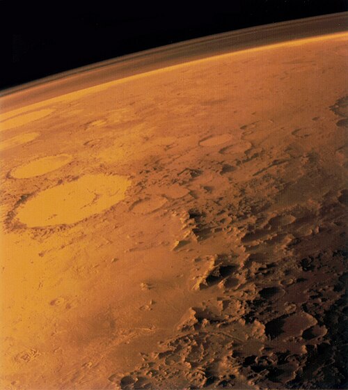
Edge-on view of Mars atmosphere by Viking 1 probe