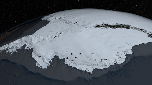
The West Antarctic Ice Sheet (WAIS) is the segment of the continental ice sheet that covers West Antarctica, the portion of Antarctica on the side of the Transantarctic Mountains that lies in the Western Hemisphere. It is classified as a marine-based ice sheet, meaning that its bed lies well below sea level and its edges flow into floating ice shelves. The WAIS is bounded by the Ross Ice Shelf, the Ronne Ice Shelf, and outlet glaciers that drain into the Amundsen Sea.
1957-2007 Antarctic surface temperature trends, in °C/decade.
Thwaites Glacier, with its vulnerable bedrock topography visible.
An illustration of the theory behind marine ice sheet and marine ice cliff instabilities.
Diagram of a proposed "curtain".
The Antarctic ice sheet is a continental glacier covering 98% of the Antarctic continent, with an area of 14 million square kilometres and an average thickness of over 2 kilometres (1.2 mi). It is the largest of Earth's two current ice sheets, containing 26.5 million cubic kilometres of ice, which is equivalent to 61% of all fresh water on Earth. Its surface is nearly continuous, and the only ice-free areas on the continent are the dry valleys, nunataks of the Antarctic mountain ranges, and sparse coastal bedrock. However, it is often subdivided into East Antarctic ice sheet (EAIS), West Antarctic ice sheet (WAIS), and Antarctic Peninsula (AP), due to the large differences in topography, ice flow, and glacier mass balance between the three regions.
South facing visualization of the Antarctic ice sheet from the Pacific sector of the Southern Ocean (West Antarctic ice sheet, foreground; Antarctic Peninsula, to the left; East Antarctic ice sheet, background).
Antarctic Skin Temperature Trends between 1981 and 2007, based on thermal infrared observations made by a series of NOAA satellite sensors. Skin temperature trends do not necessarily reflect air temperature trends.
Parts of East Antarctica (marked in blue) are currently the only place on Earth to regularly experience negative greenhouse effect during certain months of the year. At greater warming levels, this effect is likely to disappear due to increasing concentrations of water vapor over Antarctica
Antarctic surface temperature trends, in °C/decade. Red represents areas where temperatures have increased the most since the 1950s.


