West Jerusalem
Videos
Page
West Jerusalem or Western Jerusalem refers to the section of Jerusalem that was controlled by Israel at the end of the 1948 Arab–Israeli War. As the city was divided by the Green Line, West Jerusalem was formally delineated as the counterpart to East Jerusalem, which was controlled by Jordan. Though Israel has controlled the entirety of Jerusalem since the 1967 Arab–Israeli War, the boundaries of West Jerusalem and East Jerusalem remain internationally recognized as de jure due to their significance to the process of determining the status of Jerusalem, which has been among the primary points of contention in the Arab–Israeli conflict and the Israeli–Palestinian conflict. With certain exceptions, undivided Jerusalem is not internationally recognized as the sovereign territory of either Israel or the State of Palestine. However, recognition of Israeli sovereignty over only West Jerusalem is more widely accepted as a plausible diplomatic position, as the United Nations regards East Jerusalem as part of the Israeli-occupied West Bank.
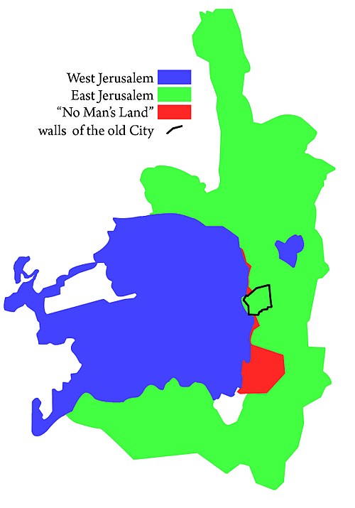
Zones of control in Jerusalem between 1948 and 1967

William McLean's 1918 plan was the first urban planning scheme for Jerusalem. It laid the foundations for what became West Jerusalem and East Jerusalem.

Palmach soldiers attack Arab positions at St Symeon ("San Simon") Monastery in Katamon, Jerusalem, April 1948 (battle reconstruction)
Jerusalem
Videos
Page
Jerusalem is a city in the Southern Levant, on a plateau in the Judaean Mountains between the Mediterranean and the Dead Sea. It is one of the oldest cities in the world, and is considered holy to the three major Abrahamic religions—Judaism, Christianity, and Islam. Both the State of Israel and Palestine claim Jerusalem as their capital. Israel maintains its primary governmental institutions there, and Palestine ultimately foresees it as its seat of power. Neither claim is widely recognized internationally.

Image: Jerusalem 1712855

Image: המצודה בלילה

Image: הרברט סמואל ירושלים

Image: Jerusalem Chords Bridge 5 (cropped)