Klin (mountain)
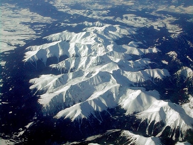
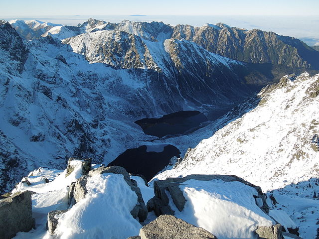
Klin is a peak in the Western Tatras, on the border between Slovakia and Poland. Its summit is at 2,176 m AMSL, it is the highest peak in Polish Western Tatras. The foreground is a classic split ridge or doppelgrat, spreading under tension due to deep erosion in the valleys either side; the finest example in the Tatra is between Kamienista and Smreczynski Wierch nearby
Mountain range
A mountain range or hill range is a series of mountains or hills ranged in a line and connected by high ground. A mountain system or mountain belt is a group of mountain ranges with similarity in form and alignment that have arisen from the same cause an orogeny. Mountain ranges are formed by a variety of geological processes, but most of the significant ones on Earth are the result of plate tectonics. Mountain ranges are found on many planetary mass objects in the Solar System and are a feature of most terrestrial planets. Mountain ranges are segmented by highlands or mountain passes and valleys. Individual mountains within the same mountain range do not have the same geologic structure or petrology, they may be a mix of different orogenic expressions and terranes, for example thrust sheets, uplifted blocks, fold mountains, volcanic landforms resulting in a variety of rock types. Most geologically young mountain ranges on the Earth's land surface are associated with either the Pacific Ring of Fire or the Alpide Belt.
The Pacific Ring of Fire includes the Andes of South America, extends through the North American Cordillera along the Pacific Coast, the Aleutian Range, on through Kamchatka, Taiwan, the Philippines, Papua New Guinea, to New Zealand. The Andes is 7,000 kilometres long and is considered the world's longest mountain system; the Alpide belt includes Indonesia and Southeast Asia, through the Himalaya, Caucasus Mountains, Balkan Mountains fold mountain range, the Alps, ends in the Spanish mountains and the Atlas Mountains. The belt includes other European and Asian mountain ranges; the Himalayas contain the highest mountains in the world, including Mount Everest, 8,848 metres high and traverses the border between China and Nepal. Mountain ranges outside these two systems include the Arctic Cordillera, the Urals, the Appalachians, the Scandinavian Mountains, the Great Dividing Range, the Altai Mountains and the Hijaz Mountains. If the definition of a mountain range is stretched to include underwater mountains the Ocean Ridges form the longest continuous mountain system on Earth, with a length of 65,000 kilometres.
The mountain systems of the earth are characterized by a tree structure, where mountain ranges can contain sub-ranges. The sub-range relationship is expressed as a parent-child relationship. For example, the White Mountains of New Hampshire and the Blue Ridge Mountains are sub-ranges of the Appalachian Mountains. Equivalently, the Appalachians are the parent of the White Mountains and Blue Ridge Mountains, the White Mountains and the Blue Ridge Mountains are children of the Appalachians; the parent-child expression extends to the sub-ranges themselves: the Sandwich Range and the Presidential Range are children of the White Mountains, while the Presidential Range is parent to the Northern Presidential Range and Southern Presidential Range. The position of mountains influences climate, such as snow; when air masses move up and over mountains, the air cools producing orographic precipitation. As the air descends on the leeward side, it warms again and is drier, having been stripped of much of its moisture.
A rain shadow will affect the leeward side of a range. Mountain ranges are subjected to erosional forces which work to tear them down; the basins adjacent to an eroding mountain range are filled with sediments which are buried and turned into sedimentary rock. Erosion is at work while the mountains are being uplifted until the mountains are reduced to low hills and plains; the early Cenozoic uplift of the Rocky Mountains of Colorado provides an example. As the uplift was occurring some 10,000 feet of Mesozoic sedimentary strata were removed by erosion over the core of the mountain range and spread as sand and clays across the Great Plains to the east; this mass of rock was removed as the range was undergoing uplift. The removal of such a mass from the core of the range most caused further uplift as the region adjusted isostatically in response to the removed weight. Rivers are traditionally believed to be the principal cause of mountain range erosion, by cutting into bedrock and transporting sediment.
Computer simulation has shown that as mountain belts change from tectonically active to inactive, the rate of erosion drops because there are fewer abrasive particles in the water and fewer landslides. Mountains on other planets and natural satellites of the Solar System are isolated and formed by processes such as impacts, though there are examples of mountain ranges somewhat similar to those on Earth. Saturn's moon Titan and Pluto, in particular exhibit large mountain ranges in chains composed of ices rather than rock. Examples include the Mithrim Montes and Doom Mons on Titan, Tenzing Montes and Hillary Montes on Pluto; some terrestrial planets other than Earth exhibit rocky mountain ranges, such as Maxwell Montes on Venus taller than any on Earth and Tartarus Montes on Mars, Jupiter's moon Io has mountain ranges formed from tectonic processes including Boösaule Montes, Dorian Montes, Hi'iaka Montes and Euboea Montes. Peakbagger Ranges Home Page Bivouac.com
Bystrá (mountain)
Bystrá is the highest mountain in the Western Tatras in Slovakia, near the Polish border. It is 2,248 meters high and surrounded by the valleys of Kamenistá, Račkova and Bystrá. Tatra Mountains go-zakopane.com
Volovec (Tatra)
Volovec or Wołowiec is a mountain in the Western Tatras at the border of Slovakia and Poland. It lies on the Main Ridge of Western Tatras between Ostrý Roháč and mountain Deravá, standing over three valleys: Chochołowską, Roháčska and Jamnícka, it offers views over the Polish Western Tatras, Slovak Roháče. Janusz Chmielowski wrote in 1898: "The summit is interesting, in the south rises the jagged group of Rohacz / Roháče, toward the east the High Tatras just like a giant rocky island On the north stands the dome of Babia Góra. On the west lie below the Roháčske Ponds." The mountain's height was determined in 1820 and it was used as an important triangulation point. The peak is located at a junction of three ridges: from the east from Jarząbczy Wierch / Hrubý Vrch and Łopata / Lopata from the south from Ostrý Roháč / Rohacz Ostry and Plačlivé / Rohacz Placzliwy from the north from Rákon / Rakoń and Grześ Volovec lies on the Main Ridge of Western Tatras between Ostrý Roháč and mountain Deravá, close to mountain Rákoň.
Starting from Volovec, the Main Ridge acts as the border between Slovakia. The mountain consists of metamorphic rock. Local fauna include the Tatra chamois and Alpine marmot. There are two marked hiking trails which lead to the summit of Volovec and blue. A third, green one, connects with the blue one at the saddle beneath the mountain. All routes pose no technical difficulty and when taking into account the large distance and altitude difference involved, the summit is one of the most challenging climbs in Western Tatras accessible to children. An exception to this is trying to access Volovec through Ostrý Roháč and Jamnícke saddle, one of the most exposed climbs on the main ridge of Western Tatras. Red trail from Jarząbczy Wierch / Hrubý Vrch Blue trail from village Oravice through Jamnícka valley Green trail from Polana Chochołowska through Dolina Chochołowska Wyżnia, it connects with the blue trail at the saddle between Rákoň and Volovec Hiking off-trails is forbidden in Polish Western Tatras and allowed only at certain areas in Slovak Western Tatras and only when accompanied by a mountain guide or when holding a UIAA license.
Tatra Mountains
Giewont
Giewont is a mountain massif in the Tatra Mountains of Poland, is 1,895 metres AMSL at its highest. It comprises three peaks: Small Giewont - Great Giewont - Long Giewont -. There is a mountain pass located between Long Giewont, known as Szczerba, it is located between the valleys of Małej Łąki and Strążyska. Long Giewont and Great Giewont are situated at a higher altitude than the nearby town of Zakopane, making them visible from that city. On Great Giewont, there is a 15 m steel cross - the site of religious pilgrimages; the area is notorious for its hazardous nature during thunderstorms, so this should be taken into consideration when approaching the summit. Geologically, Giewont is composed of dolomite and limestone caves, as well as gneiss and granite in the southern section; the first recorded ascent to Giewont's summit was undertaken in 1830 by mountaineers Franciszek Herbich and Aleksander Zawadzki. The first winter ascent of Giewont occurred in 1904 by a group of five mountaineers led by Mariusz Zaruski.
Nowadays the climbing on Giewont is banned. On the other hand, hiking on the hiking trails is allowed and the access is not difficult hence Giewont is a popular destination among amblers and Sunday tourists. In the summer up to a few thousand tourists a day ascend the top of the mountain. Giewont lies in the area of the Polish Tatra National Park. In Polish folklore it is associated with a legend about oversleeping knights, who will awake when Poland is in danger; the profile of the mountains is similar to a lying knight, wherein the Long Giewont is the knight's torso, the Great Giewont is the knight's face as viewed from the side. The image of Giewont as viewed from the north makes the profile easy to discern. Zakopane - Giewont webcam "Giewont". SummitPost.org. Giewont webcam - click "Day at a Glance" if night
Summit
A summit is a point on a surface, higher in elevation than all points adjacent to it. The topographic terms acme, apex and zenith are synonymous; the term top is used only for a mountain peak, located at some distance from the nearest point of higher elevation. For example, a big massive rock next to the main summit of a mountain is not considered a summit. Summits near a higher peak, with some prominence or isolation, but not reaching a certain cutoff value for the quantities, are considered subsummits of the higher peak, are considered part of the same mountain. A pyramidal peak is an exaggerated form produced by ice erosion of a mountain top. Summit may refer to the highest point along a line, trail, or route; the highest summit in the world is Everest with height of 8844.43 m above sea level. The first official ascent was made by Sir Edmund Hillary, they reached the mountain`s peak in 1953. Whether a highest point is classified as a summit, a sub peak or a separate mountain is subjective; the UIAA definition of a peak is.
Otherwise, it's a subpeak. In many parts of the western United States, the term summit refers to the highest point along a road, highway, or railroad. For example, the highest point along Interstate 80 in California is referred to as Donner Summit and the highest point on Interstate 5 is Siskiyou Mountain Summit. A summit climbing differs from the common mountaineering. Summit expedition requires: 1+ year of training, a good physical shape, a special gear. Although a huge part of climber’s stuff can be left and taken at the base camps or given to porters, there is a long list of personal equipment. In addition to common mountaineers’ gear, Summit climbers need to take Diamox and bottles of oxygen. There are special requirements for crampons, ice axe, rappel device, etc. Geoid Hill – Landform that extends above the surrounding terrain Nadir Summit accordance Peak finder Summit Climbing Gear List
Carpathian Mountains
The Carpathian Mountains or Carpathians are a mountain range system forming an arc 1,500 km long across Central and Eastern Europe, making them the third-longest mountain range in Europe after the Ural Mountains with 2,500 km and Scandinavian Mountains with 1,700 km. They provide the habitat for the largest European populations of brown bears, wolves and lynxes, with the highest concentration in Romania, as well as over one third of all European plant species; the Carpathians and their foothills have many thermal and mineral waters, with Romania having one-third of the European total. Romania is home to the second-largest surface of virgin forests in Europe after Russia, totaling 250,000 hectares, most of them in the Carpathians, with the Southern Carpathians constituting Europe's largest unfragmented forested area; the Carpathians consist of a chain of mountain ranges that stretch in an arc from the Czech Republic in the northwest through Slovakia, Poland and Ukraine Serbia and Romania in the southeast.
The highest range within the Carpathians is the Tatras, on the border of Slovakia and Poland, where the highest peaks exceed 2,600 m. The second-highest range is the Southern Carpathians in Romania, where the highest peaks exceed 2,500 m; the divisions of the Carpathians are in three major sections: Western Carpathians—Austria, Czech Republic, Poland and Hungary Eastern Carpathians—southeastern Poland, eastern Slovakia and Romania Southern Carpathians—Serbia and RomaniaThe term Outer Carpathians is used to describe the northern rim of the Western and Eastern Carpathians. The most important cities in or near the Carpathians are: Bratislava and Košice in Slovakia, Kraków in Poland, Cluj-Napoca and Braşov in Romania, Uzhhorod in Ukraine. In modern times, the range is called Karpaty in Czech and Slovak and Карпати in Ukrainian, Карпати / Karpati in Serbian, Carpați in Romanian, Karpaten in German, Kárpátok in Hungarian. Although the toponym was recorded by Ptolemy in the second century of the Christian era, the modern form of the name is a neologism in most languages.
For instance, Havasok was its medieval Hungarian name. Sources, such as Dimitrie Cantemir and the Italian chronicler Giovanandrea Gromo, referred to the range as "Transylvania's Mountains", while the 17th-century historian Constantin Cantacuzino translated the name of the mountains in an Italian-Romanian glossary to "Rumanian Mountains"; the name "Carpates" is associated with the old Dacian tribes called "Carpes" or "Carpi" who lived in a large area from the east, north-east of the Black Sea to Transylvanian plains on the present day Romania and Moldova. The name Carpates may be from the Proto Indo-European root *sker-/*ker-, from which comes the Albanian word karpë, the Slavic word skála via a Dacian cognate which meant mountain, rock, or rugged; the archaic Polish word karpa meant "rugged irregularities, underwater obstacles/rocks, rugged roots, or trunks". The more common word skarpa means other vertical terrain; the name may instead come from Indo-European *kwerp "to turn", akin to Old English hweorfan "to turn, change" and Greek καρπός karpós "wrist" referring to the way the mountain range bends or veers in an L-shape.
In late Roman documents, the Eastern Carpathian Mountains were referred to as Montes Sarmatici. The Western Carpathians were called Carpates, a name, first recorded in Ptolemy's Geographia. In the Scandinavian Hervarar saga, which relates ancient Germanic legends about battles between Goths and Huns, the name Karpates appears in the predictable Germanic form as Harvaða fjöllum. "Inter Alpes Huniae et Oceanum est Polonia" by Gervase of Tilbury, has described in his Otia Imperialia in 1211. Thirteenth- to fifteenth-century Hungarian documents named the mountains Thorchal, Tarczal, or less Montes Nivium; the northwestern Carpathians begin in southern Poland. They surround Transcarpathia and Transylvania in a large semicircle, sweeping towards the southeast, end on the Danube near Orşova in Romania; the total length of the Carpathians is over 1,500 km and the mountain chain's width varies between 12 and 500 km. The highest altitudes of the Carpathians occur; the system attains its greatest breadth in the Transylvanian plateau and in the southern Tatra Mountains group – the highest range, in which Gerlachovský štít in Slovakia is the highest peak at 2,655 m above sea level.
The Carpathians cover an area of 190,000 km2, after the Alps, form the next-most extensive mountain system in Europe. Although referred to as a mountain chain, the Carpathians do not form an uninterrupted chain of mountains. Rather, they consist of several orographically and geologically distinctive groups, presenting as great a structural variety as the Alps; the Carpathians, which attain an altitude over 2,500 m in only a few places, lack the bold peaks, extensive snowfields, large glaciers, high waterfalls, numerous large lakes that are common in the Alps. It was believed that no area of the Carpathian range was covered in snow all yea